
Flaxton, Queensland facts for kids
Quick facts for kids FlaxtonQueensland |
|||||||||||||||
|---|---|---|---|---|---|---|---|---|---|---|---|---|---|---|---|

View from Flaxton towards the Pacific Ocean, 2012
|
|||||||||||||||

Flaxton
Location in Queensland
|
|||||||||||||||
| Population | 992 (2021 census) | ||||||||||||||
| • Density | 85.5/km2 (221/sq mi) | ||||||||||||||
| Postcode(s) | 4560 | ||||||||||||||
| Area | 11.6 km2 (4.5 sq mi) | ||||||||||||||
| Time zone | AEST (UTC+10:00) | ||||||||||||||
| Location |
|
||||||||||||||
| LGA(s) | Sunshine Coast Region | ||||||||||||||
| State electorate(s) | Glass House | ||||||||||||||
| Federal Division(s) | Fairfax | ||||||||||||||
|
|||||||||||||||
Flaxton is a small, quiet area in the Sunshine Coast Region of Queensland, Australia. It's a rural place, meaning it has more farms and open spaces than big cities. In 2021, about 992 people lived there. Flaxton is known for its beautiful views, especially towards the Pacific Ocean.
Contents
A Look Back: Flaxton's History
How Flaxton Got Its Name
Flaxton is named after a farm in England called Flaxton Hall Farm. In 1882, a man named Joseph Dixon chose land here. He used to grow sugarcane in Buderim.
Early Farming in Flaxton
Starting in 1892, the land in Flaxton was cleared. This made it ready for growing bananas and citrus fruits like oranges and lemons. Farming was a big part of life here for many years.
The First School in Flaxton
In 1921, local families wanted a school for their children. Mr. J. C. Dixon senior gave one acre of his land for the school. This spot had amazing views of the coast!
Because the government wasn't likely to build a state school, the people of Flaxton decided to raise money themselves. They built a "provisional school," which was a temporary school. It could also be used as a public hall for meetings and events. Flaxton Provisional School opened in February 1922 and closed in 1967. It was located at 360-362 Flaxton Drive.
Local Businesses and Industries
In 1931, a special shed was opened to pack all the fruit grown in the area. This helped farmers get their produce ready for sale. A sawmill also operated in Flaxton for over 20 years. Sadly, it burned down in 1956.
The Flaxton Model Village
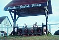
On March 21, 1970, a fun new attraction opened: the Flaxton Model Village. Mr. and Mrs. Malcolm Bradley built and ran it. This village had tiny, one-twelfth scale models of old English buildings. You could see a castle, a water mill, a church, and a market square, all in miniature! There were also life-sized buildings that were used as a theatre, a cafe, and a shop.
Who Lives in Flaxton?
In 2016, Flaxton had 931 people living there. By 2021, the population had grown slightly to 992 people.
Learning in Flaxton
There are no schools directly in Flaxton. Kids living here usually go to primary school in nearby towns. The closest government primary schools are Mapleton State School in Mapleton (to the north) and Montville State School in Montville (to the south). For high school, students typically attend Burnside State High School in Burnside, which is to the north-east.
Places to Visit: Parks in Flaxton
Flaxton has several parks where you can enjoy nature and relax:
- Carramar Court Park
- Cynthia Hunt Drive Bushland Conservation Reserve
- Flaxton Drive Park
- Flaxton Drive Natural Amenity Reserve
- Nimbus Drive Park
Images for kids
-
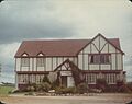
Flaxton Inn, 1976
-
Life-sized stocks at the Flaxton Model Village, 1978


