
Forest Heritage Scenic Byway facts for kids
Quick facts for kids
[[File:|x70px|alt= marker]] |
|
|---|---|
| Lua error in Module:Infobox_road/map at line 15: attempt to index field 'wikibase' (a nil value). | |
| Route information | |
| Maintained by NCDOT | |
| Length | 76.7 mi (123.4 km)
NSB: 17.6 miles (28.3 km)
NCSB: 64.4 miles (103.6 km) |
| Existed | 1989–present |
| Component highways |
|
| Major junctions | |
| Location | |
| Counties: | Transylvania, Jackson, Haywood |
| Highway system | |
| North Carolina Highway System | |
The Forest Heritage Scenic Byway is a special road in Western North Carolina. It stretches about 76.7-mile (123.4 km) through the beautiful Pisgah National Forest. This byway is known for its amazing views, cool waterfalls, and fun trails. It's also home to the Cradle of Forestry in America, where American forestry began!
Contents
Explore the Forest Heritage Byway
This scenic road starts near Rosman. It's about 2,201 ft (671 m) high there. As you travel north, you'll follow the North Fork French Broad River.
Waterfalls and High Peaks
Near the community of Balsam Grove, you can find Courthouse Falls. You can get there by taking Forest Road 140. The byway then climbs to Pinhook Gap, which is 4,170 ft (1,270 m) high. It briefly enters Jackson County before returning to Transylvania County.
The highest point on the byway is Beech Gap, at 5,335 ft (1,626 m). Here, the road enters Haywood County. It also connects with the famous Blue Ridge Parkway. As the road goes down from the Pisgah Ridge, it follows the West Fork Pigeon River. This leads to Lake Logan, which is 2,910 ft (890 m) high. This lake covers an old logging town called Sunburst.
From Woodrow to Brevard
In Woodrow, named after President Woodrow Wilson, the byway changes roads. It switches from NC 215 to US 276. Now, the byway follows the East Fork Pigeon River. It slowly climbs between Cold Mountain and Mount Pisgah.
At Shining Creek Gap, 3,671 ft (1,119 m) high, you'll find the Shining Rock Trail Head. This is where the National Scenic Byway section begins. The road then climbs quickly up the Pisgah Ridge again. It crosses back into Transylvania County at Wagon Road Gap, 4,528 ft (1,380 m) high. Here, it connects with the Blue Ridge Parkway once more. Then, it makes a sharp turn to go down into an area called the Pink Beds.
The Pink Beds and Fun Spots
The Pink Beds is a unique wetland area. It's filled with beautiful pink rhododendrons and laurels. Close by is the Cradle of Forestry in America. This is where the very first school for forestry in America, the Biltmore Forest School, started in 1898. It was founded by Carl A. Schenck.
Just three miles south of the Cradle of Forestry is Sliding Rock. This is a super popular spot in summer! Visitors can slide down smooth rocks into a cool pool of water. Nearby, you'll find Looking Glass Falls. This waterfall is named because its water looks like a mirror shining off the granite rock.
The Pisgah Forest National Fish Hatchery is also in this area. It's located along the Davidson River. Here, trout fish are raised and then released into the local rivers.
End of the Byway Loop
Near Brevard, you can visit the Pisgah Visitor Center. This area, called Sycamore Flats, was once a community. You can still see the historic English Chapel there. You might also spot two stone pillars. These were built to honor local soldiers who served in World War I. They also mark the edge of the Pisgah National Forest.
The North Carolina Scenic Byway and National Scenic Byway parts end near Brevard. However, the National Forest Scenic Byway continues. It goes through Brevard on US 64 to complete a full loop back to NC 215. Even though it's part of the loop, you won't see special byway signs on this last section of US 64.
Old Railroads and Road Grades
Much of this scenic byway was built on old railroad tracks. These tracks were used for logging in the late 1800s and early 1900s. The roads, NC 215 and US 276, have steep sections. Some parts have a 9% slope and sharp curves. This means drivers, especially those in large trucks, might need to slow down to about 15 miles per hour (24 km/h). Because of these steep grades and curves, the byway is not always recommended for large recreational vehicles or buses.
Different Byway Types
The Forest Heritage Scenic Byway is actually made up of three different scenic byways:
- The National Forest Scenic Byway is the longest. It forms a loop using NC 215, US 276, and US 64.
- The National Scenic Byway is the shortest. It's about 17.6 miles (28.3 km) long and follows US 276.
- The North Carolina Scenic Byway is about 64.4 miles (103.6 km) long. It uses both NC 215 and US 276.
History of the Byway
The Forest Heritage Scenic Byway was first created in 1989. It was recognized by the United States Forest Service (USFS). A year later, in 1990, it also became a North Carolina Scenic Byway. Later, in 2009, a part of the US 276 section of the byway received another special title. It was named a National Scenic Byway by the United States Department of Transportation (USDOT).
Images for kids
-
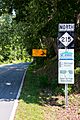
The first sign for the Forest Heritage Scenic Byway along NC 215.

