
Fort Hays facts for kids
Quick facts for kids Fort Hays |
|
|---|---|
| 1472 U.S. Highway 183 Alt, Hays, Kansas in United States | |

The stone blockhouse at Fort Hays
|
|

Fort Hays
Location in Kansas
|
|
| Coordinates | 38°51′42″N 99°20′32″W / 38.86167°N 99.34222°W |
| Type | Military base |
| Site information | |
| Owner | Kansas Historical Society |
| Open to the public |
Yes |
| Condition | Partially dismantled; remnants preserved as a historical site |
| Site history | |
| Built | 1865 (1st site) 1866 (2nd site) 1867 (final site) |
| Built by | U.S. Army |
| In use | 1865-1889 |
| Garrison information | |
| Past commanders |
Nelson Miles Philip Sheridan |
| Garrison | 5th Infantry Regiment 7th Cavalry Regiment 10th Cavalry Regiment 38th Infantry Regiment |
|
Fort Hays State Historic Site
|
|
| Location | Frontier Historical Park, Hays, Kansas |
| Area | 177 acres (72 ha) |
| Built | 1867 |
| NRHP reference No. | 71000314 |
| Added to NRHP | January 25, 1971 |
Fort Hays, first called Fort Fletcher, was an important United States Army base near Hays, Kansas. It was active from 1865 to 1889. This fort played a big role on the American Frontier during the American Indian Wars in the late 1800s. Today, it is a historical park run by the Kansas Historical Society and is known as the Fort Hays State Historic Site. It reopened as a park in 1929.
Contents
The Story of Fort Hays
Why Fort Hays Was Built
The U.S. Army built Fort Fletcher on October 11, 1865. Its main job was to protect travelers on the Smoky Hill Trail. This trail was used by Butterfield Overland Despatch stagecoaches and wagons carrying goods. They needed protection from attacks by the Cheyenne and Arapaho tribes.
The fort was named after Thomas C. Fletcher, who was the governor of Missouri at the time. It was located near a creek in western Kansas. Soldiers from the 1st U.S. Volunteer Infantry and the 13th Missouri Cavalry were stationed there. Even with the soldiers, attacks on the stage line continued. The company eventually went out of business, and the trail was no longer used. Fort Fletcher closed on May 5, 1866.
A New Purpose and Name

The Army reopened Fort Fletcher on October 11, 1866. This time, it was built a short distance north of the first site. Its new purpose was to protect workers building the Kansas Pacific Railway (a railroad) heading west.
A month later, in November, the fort's name changed to Fort Hays. It was named after Alexander Hays, a brave general who died during the American Civil War. On June 7, 1867, a big flood almost destroyed the fort. Nine soldiers and civilians lost their lives.
Moving to a Final Location
The Army wanted Fort Hays to be a main supply center for other forts. This meant it needed to be close to the railroad. However, the railroad was planned to be five miles north of the fort. Because of this and the flood damage, the Army decided to move the fort again.
On June 23, 1867, Fort Hays moved to its final spot, about 15 miles northwest. This new location was where the railroad would cross Big Creek. Soon, people started to settle nearby, attracted by the fort and the railroad. They created towns like Rome and Hays City, with Hays City named after the fort.
Life at the Fort
Fort Hays covered a large area, about 7,500 acres. Unlike many forts you might imagine, it didn't have tall walls around it. It looked more like a small town on the frontier. The only real defensive building was a blockhouse.
The fort's main job was to be a base for supplies and soldiers. From here, troops could quickly go out to protect people and places when conflicts with Plains Indians happened. Over time, the fort grew to have about 45 buildings.
The Blue Light Lady
In the summer of 1867, a sickness called cholera spread through the area. Elizabeth Polly, a woman who helped care for the sick at the fort, became one of the victims. She was buried near a hill. People later claimed to see her ghost in the area, calling her the "Blue Light Lady." This made her a part of local legends.
Important Role in History
Fort Hays became a very important Army base during the Indian Wars. It was a place where soldiers started their missions and where supplies were kept for other forts.
Philip Sheridan, a major general, used Fort Hays as his main base in 1868-1869. He led a campaign against the Cheyenne and Kiowa tribes, with help from George Armstrong Custer and the 7th Cavalry. Famous scouts like Buffalo Bill Cody and Wild Bill Hickok also worked at Fort Hays during this time.
Later, Nelson A. Miles took command in 1869. His 5th Infantry protected the railroad as it continued to be built west into Colorado Territory. Soldiers known as "Buffalo Soldiers" from the 10th Cavalry and the 38th Infantry Regiment were also stationed at the fort. In 1869, a disagreement between soldiers and civilians in Hays led to a fight.
The Fort Closes
The U.S. Army used Fort Hays until June 1, 1889, and officially closed it on November 8, 1889. The Kansas Legislature wanted the land for a home for old soldiers. Later, they asked for it to be used for education and fun.
In 1900, the U.S. Congress agreed to give the Fort Hays land to the state of Kansas. It was to be used for an agricultural experiment station and a branch of a normal school (a school for training teachers). The school opened in 1902 and eventually became Fort Hays State University. The experiment station is still used today for agricultural research by Kansas State University.
Most of the fort's buildings were sold off in 1902. What was left of the land became Frontier Historical Park in 1929. A museum opened there in 1955. In 1967, it became a state historic site and is now managed by the Kansas Historical Society.
Fort Hays State Historic Site Today
_3_20160619.jpg)
The Kansas Historical Society takes care of the Fort Hays State Historic Site. You can visit it today! The site has a visitor center, the old parade ground, and four of the original buildings. These include the blockhouse, the guardhouse, and two officers' quarters.
The blockhouse (built in 1867) and the guardhouse (built in 1872) have exhibits. They show what life was like for soldiers and how the fort was built. The two officers' quarters are restored with furniture from the 1860s to 1880s. The visitor center, built in 1967, has exhibits about the conflicts between the U.S. and the Plains Indians. It also displays artifacts from that time. There are also exhibits about the civilians who lived and worked at the fort. A sculpture called Monarch of the Plains was placed there in 1967 to celebrate the fort's 100th anniversary.
Where to Find the Site
The Fort Hays State Historic Site is located southwest of Hays, Kansas. It covers 177 acres. The main campus of Fort Hays State University is just north of the site.
The very first Fort Fletcher (1865-1866) was a bit southeast of the current site. The second Fort Fletcher (1866-1867), which was renamed Fort Hays, was also in that area. The historic site you can visit today is at the final location where Fort Hays moved in June 1867.
Famous People Connected to Fort Hays
Many interesting people lived, worked, or visited Fort Hays:
- Buffalo Bill Cody (1846-1917), a famous scout and showman.
- George Armstrong Custer (1839-1876), a U.S. Army general.
- Wild Bill Hickok (1837-1876), another well-known scout and lawman.
- Nelson A. Miles (1839-1925), a U.S. Army general.
- Elizabeth Polly (?-1867), the hospital matron who became a local legend.
- Philip Sheridan (1831-1888), a top U.S. Army general.
- George Miller Sternberg (1838-1915), an Army doctor and early scientist.
- Alexander Gardner (1821-1882), a famous photographer who visited in 1867.
- Henry Morton Stanley (1841-1904), a journalist and explorer.
Images for kids
-
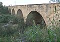
Fort Fletcher Bridge
-
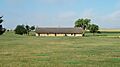
Fort Hays guardhouse, built in 1867
-
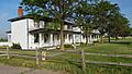
Fort Hays officers' quarters, built 1867-1870
-
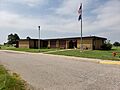
Fort Hays Visitor Center


See also
 In Spanish: Fuerte Hays para niños
