Fort Jones, California facts for kids
Quick facts for kids
Fort Jones, California
|
|
|---|---|
| City of Fort Jones | |

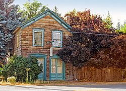
Fort Jones House
|
|

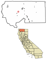
Location of Fort Jones in Siskiyou County, California
|
|
| Country | United States |
| State | California |
| County | Siskiyou |
| Incorporated | March 16, 1872 |
| Area | |
| • Total | 0.60 sq mi (1.56 km2) |
| • Land | 0.60 sq mi (1.56 km2) |
| • Water | 0.00 sq mi (0.00 km2) 0% |
| Elevation | 2,759 ft (841 m) |
| Population
(2020)
|
|
| • Total | 695 |
| • Density | 1,158/sq mi (445.5/km2) |
| Time zone | UTC-8 (Pacific (PST)) |
| • Summer (DST) | UTC-7 (PDT) |
| ZIP code |
96032
|
| Area code(s) | 530 |
| FIPS code | 06-25128 |
| GNIS feature ID | 277519, 2410527 |
| Reference #: | 317 |
Fort Jones is a small town in the Scott Valley area of Siskiyou County, California, United States. It is located near Mount Shasta, in the southern part of the Cascadia bioregion. In 2020, the town had a population of 695 people. This was a decrease from its population of 839 in 2010.
Contents
History
How Fort Jones Got Its Name
Fort Jones is recognized as a California Historical Landmark. The town gets its name from a military outpost that was once located nearby. The town's name has changed several times over the years.
Around 1850, the town was first called Scottsburg. Soon after, its name changed to Scottsville. In 1852, it was renamed Wheelock to honor Mr. O. C. Wheelock. He and his partners started the first businesses in the area.
In 1854, a post office was opened, and the town was renamed again. It became known as Ottitiewa. This was an Indian name for a branch of the Shasta tribe that lived along the Scott River. The name stayed this way until 1860. At that time, local people asked the postal department to change the name to Fort Jones, which it has been ever since.
Early Settlement and Gold Rush
The very first permanent building in the town was built in 1851. It was built by two men named Brown and Kelly. Soon after, O. C. Wheelock, Captain John B. Pierce, and two other partners bought it. They opened a trading post and a bar there. These businesses mainly served the soldiers stationed at the fort.
By the late 1850s, nearby mining camps like Hooperville and Deadwood started to close down. This happened because there was less gold to find. Also, illnesses and fires caused problems.
The gold mines around Scott Valley attracted many people from all over the United States and the world. They came because of the California Gold Rush in the 1850s. Many Irish and Portuguese immigrants stayed in the area. They became ranchers after earning enough money from gold to buy land in the valley.
In the early 1900s, many Portuguese families settled along the northern parts of the Scott River. These areas included Moffitt and McAddams creeks. A plant called Dyers Woad spread throughout Scott Valley. It came from British hay seeds that an Irish family, the Marlahans, received. This plant is now known locally as Marlahan Mustard. It has bright yellow flowers in spring. However, animals will not eat hay that has this plant in it. This has been a problem for ranchers in Scott Valley ever since.
The Military Fort
The actual military post, Fort Jones, was set up on October 18, 1852. Its first leader was Captain Edward H. Fitzgerald. The fort was named after Colonel Roger Jones, who was an important army general.
Military posts were usually built near major travel routes. This would have meant placing the fort near Yreka, about sixteen miles northeast. However, the area around Yreka did not have enough resources, like food for the animals. So, Captain Fitzgerald moved his troops about sixteen miles southwest. This area was known as Beaver Valley.
Fort Jones served the military needs of Siskiyou County for about six years. The order to leave the fort was given on June 23, 1858.
Many officers who were stationed at Fort Jones later became famous. These included Phil Sheridan and George Crook, who fought for the Union Army. Also, William Wing Loring and John B. Hood fought for the Confederate side. George Pickett was another Confederate officer. Ulysses S. Grant, who later became a famous Union commander, was supposed to go to Fort Jones. However, he was not there when he was supposed to be.
Geography
Fort Jones is located at 41°36′26″N 122°50′31″W / 41.60722°N 122.84194°W.
The city covers a total area of about 0.6 square miles (1.56 square kilometers). All of this area is land.
Climate
Fort Jones has a climate with warm, dry summers. The average monthly temperatures do not go above 71.6°F (22°C). This type of weather is called a warm-summer Mediterranean climate. It is known for its mild, wet winters and hot, dry summers.
Population
The population of Fort Jones has changed over the years. Here is a look at how many people have lived there during different census years:
| Historical population | |||
|---|---|---|---|
| Census | Pop. | %± | |
| 1890 | 266 | — | |
| 1900 | 356 | 33.8% | |
| 1910 | 316 | −11.2% | |
| 1920 | 331 | 4.7% | |
| 1930 | 302 | −8.8% | |
| 1940 | 360 | 19.2% | |
| 1950 | 525 | 45.8% | |
| 1960 | 483 | −8.0% | |
| 1970 | 515 | 6.6% | |
| 1980 | 544 | 5.6% | |
| 1990 | 639 | 17.5% | |
| 2000 | 660 | 3.3% | |
| 2010 | 839 | 27.1% | |
| 2020 | 695 | −17.2% | |
| U.S. Decennial Census | |||
In 2020, Fort Jones had a population of 695 people. Most residents were White. There were also people of African American, American Indian, Asian, and other backgrounds. About 13.2% of the population identified as Hispanic or Latino.
In 2010, the population was 839 people. The town had about 1,393 people per square mile. Most people lived in homes, while some were in institutions.
Notable People
- Lauran Paine (1916 – 2001) was a very productive author. He wrote over 1,000 books, many of them Western stories. He used many different pen names, like Mark Carrel and Clay Allen. He lived in Fort Jones for a long time. One of his stories was even made into a movie called Open Range.
- John King Luttrell (1831 – 1893) was a U.S. Representative for California. He moved to Siskiyou County in 1858. He bought a ranch near Fort Jones and worked in farming and mining. He also practiced law. Later, he became a U.S. Commissioner of Fisheries. He died in Alaska and was buried in the Fort Jones Cemetery.
See also
 In Spanish: Fort Jones para niños


