Cascadia (bioregion) facts for kids
The idea of Cascadian bioregionalism is about understanding and living in harmony with a specific natural area. It combines ideas from science, environmental care, art, and community efforts. A bioregion is a special place defined by its unique natural features. These include its climate, seasons, landforms, rivers (watersheds), soil, and native plants and animals. People are also a key part of a bioregion. This includes how early people lived in balance with nature and how people today try to live sustainably.
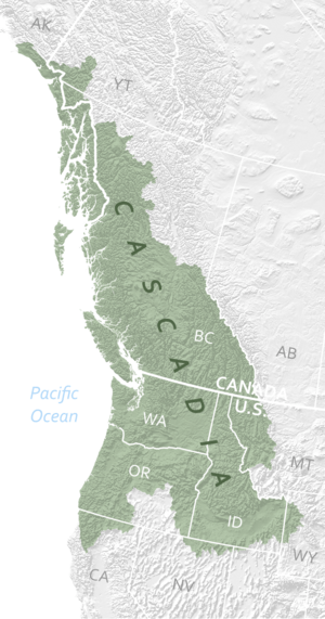
The Cascadia bioregion is huge! It has 75 different ecoregions. It stretches over 2,500 miles from the Copper River in Southern Alaska down to Cape Mendocino in California. To the east, it reaches the Yellowstone Caldera and the continental divide. Cascadian bioregionalism focuses on the shared natural, environmental, economic, and cultural connections across the U.S. Pacific Northwest. It suggests that people in Washington and Oregon have more in common with those in British Columbia, Canada, than with people in Washington D.C..
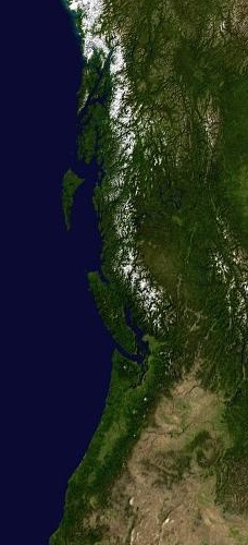
The Cascadia Bioregion is also called the Pacific Northwest Bioregion. It covers all of Washington state and parts of Oregon, Idaho, California, Nevada, Wyoming, Montana, Alaska, Yukon, and British Columbia. Bioregions are areas defined by their land, soil, water systems, climate, plants, and animals. The Cascadia Bioregion includes the entire Columbia River watershed and the Cascade Mountain Range. It also includes the ocean and its ecosystems out to the continental slope. The main goal of defining a bioregion is to protect the environment. The idea is that political borders should match natural and cultural areas.
The area from Vancouver, B.C. to Portland, Oregon is known as a megaregion. This is especially true along the 'Cascadian Corridor'. Megaregions are places where city boundaries start to blend together. They share economic systems, natural resources, ecosystems, and transportation. This corridor holds only 17% of Cascadia's land but over 80% of its people.
What is Cascadia?
The name "Cascades" was first used for the Cascades Rapids long ago. The term for the mountain range appeared in 1825. Geologists started using the term for the whole region in the early 1900s. The town of Cascadia, Oregon, settled in 1890, was the first to use the name.
The name "Cascadia" was first used for the entire geological region by Bates McKee in his 1972 book, Cascadia; the geologic evolution of the Pacific Northwest. Later, David McCloskey, a professor, used the name to describe it as a bioregion. McCloskey calls Cascadia "a land of falling waters." He highlights how its natural beauty and shared culture define it.
McCloskey suggested the boundaries for Cascadia. These include the full watershed of the Columbia River. This covers parts of Idaho, western Montana, and smaller areas of Wyoming, Utah, and northern Nevada. According to McCloskey, this "initial" Cascadia included parts of seven areas: Northern California, Oregon, Washington, Idaho, Western Montana, British Columbia, and Southeast Alaska. It stretched from Southeast Alaska in the north to Cape Mendocino, California in the south. It covered all the land and "falling waters" from the Rocky Mountains to the Pacific Ocean. McCloskey believes that being Cascadian is more about shared culture and ideas than just political borders.
Understanding Bioregionalism
Bioregionalism is a cultural idea. So, describing a bioregion uses information from many sources, not just science. It's about a geographic area and a way of thinking. Studies of people, history, social changes, customs, traditions, and art all play a part. Bioregionalism has three main goals:
- To bring back and protect local natural systems.
- To find sustainable ways to meet basic human needs like food, water, and shelter.
- To support people who want to live in harmony with their local environment.
This last goal involves projects, jobs, education, and even protests against harm to nature.
Bioregional goals look different in different places. For example, in the Midwest, people might work to restore native prairie grasses. In northern California, bringing back salmon runs is a top priority. In the rainy Cascadia Bioregion, using geothermal and wind energy makes sense. In the sunny Sonoran Desert, solar energy is a better choice. Education about local nature also changes from place to place.
Many fields that care about environmental sustainability like bioregional thinking. In the early 1970s, the modern idea of bioregionalism began. Scientists, activists, artists, writers, and community leaders worked together. They wanted to do "more than just save what's left" of nature. The Planet Drum Foundation in San Francisco helped spread these ideas. By the late 1970s, groups like the Frisco Bay Mussel Group in California and the Ozark Area Community Congress formed. They worked on local economic, social, and cultural issues. The Mussel Group helped stop a plan to divert fresh water from San Francisco Bay. Today, hundreds of similar groups exist worldwide.
Many people who work on ecological sustainability like bioregional ideas. People who restore ecosystems understand how important local culture is for bringing back native plants and animals. City planners use bioregions to fit redesigned cities into a larger natural setting. Organic farmers use methods that suit their local areas. They focus on healthy soil, water, and native species. Artists use bioregional themes in their work. Teachers introduce these ideas to students. Even large environmental groups now use "ecoregions" to help their members.
Bioregionalists care most about their local areas. There are many ways they help local sustainability. This includes planting trees in rural areas and creating community gardens in cities. Their influence is strongest at the county and city levels, where their work is most visible. Groups focused on watersheds (areas drained by a river or creek) are growing. They suggest things like restoring creeks, saving water, and even redrawing political borders to match watershed lines.
Ecoregions of Cascadia
Ecoregions are like the different rooms in the house of a bioregion. An Ecoregion is a regional ecosystem. It's an area with similar geography, ecology, and culture. Ecoregions are distinct places that show the variety within a large region like Cascadia.
Mapping ecoregions has two main purposes. First, it provides a common way to manage natural resources. Second, it helps people connect more deeply with the land and each other. This leads to better community organization. An ecoregion is known by its unique character (like the Okanogan Highlands). It's also known by how it fits into the larger region (like Okanogan in relation to the Columbia Plateau).
An ecoregion can be studied in terms of its physical, biological, and cultural aspects. First, we map the landforms, geology, climate, and water systems. We see how these factors create a common environment for life. Second, we map the plants and animals, especially the typical plant communities. We link them to their habitats. Third, we look at native peoples, early settlements, and current land use. All these layers of information come together to show the regional system. No single factor, like climate, explains everything.
Ecoregion boundaries are natural. They are often soft transition areas, not sharp political lines. A boundary is where several important factors end and begin. These borders show the natural limits of a place. They also connect this local diversity to the larger world.
Since ecosystems are open and don't have exact boundaries, watersheds are often used to represent them. Ecoregions are often drawn as a series of connected watersheds with similar characteristics. However, if other factors are more important, like landforms or major cultural boundaries, then watershed lines might be crossed. The key is to be true to the land and its people. An ecoregion is larger than a watershed but smaller than a bioregion. In political terms, it's larger than a county but smaller than a state or province. There are over 75 ecoregions in Cascadia's more than 750,000 square miles. They average about 10,000 square miles each, but can range from 2,000 to over 30,000 square miles. The size depends on the unique nature of the place itself.
Cascadia in Politics
Cascadian bioregionalism also inspires several groups that want independence for the Pacific Northwest. These groups base their proposed borders on the Cascadia bioregion. For more information, you can look up Cascadia (independence movement).
 | Sharif Bey |
 | Hale Woodruff |
 | Richmond Barthé |
 | Purvis Young |


