
Fort Maurepas facts for kids

Fort Maurepas, also called Old Biloxi, was an important French fort built in April 1699. It was located along the Gulf of Mexico in what is now Ocean Springs, Mississippi. This fort was the first temporary capital of Louisiana (New France), a huge area claimed by France in North America.
The capital later moved to Mobile in 1710, and then to New Orleans in 1723. New Orleans was still being built at that time.
Contents
What's in a Name?
The name Biloxi comes from a local Native American tribe. The French spelled it Bilocci.
The fort was also called Fort Maurepas to honor a French official named Louis Phélypeaux, comte de Maurepas. He was from a city in France called Maurepas. On old English maps from the 1710s and 1720s, it was sometimes called "Fort Bilocci."
The French lands in North America were known as La Louisiane. Today, people call it La Louisiane française to avoid confusing it with the modern state of Louisiana.
Building and Living at the Fort
The construction of Fort Maurepas was finished on May 1, 1699. It was led by a French explorer named Pierre Le Moyne d'Iberville. He sailed back to France a few days later.
D'Iberville put his younger brother, Jean-Baptiste Le Moyne de Bienville, in charge as second-in-command. The main leader was a French commandant named Sauvolle de la Villantry.

D'Iberville had first wanted to build a French colony along the Mississippi River. But the river flooded often, and he couldn't find a good spot during his first trip in March 1699.
He returned from the river on April 1. He then spent a week looking for a suitable place near Ship Island, where his ships were anchored.
Choosing the Fort's Location
On April 7, 1699, d'Iberville and Surgeres found a "very suitable" elevated spot. This was on the northeast shore of Biloxi Bay. They saw that the bay was deep enough for ships.
They decided to build the fort there because they couldn't find a better place. Also, their supplies were running low. On April 8, they started cutting down trees to prepare for building. Everyone worked hard, and the fort was finished by the end of the month. They also carved a stone, known as the Iberville stone, to claim the land for France. This stone is now in a museum.
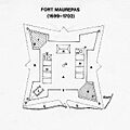
What the Fort Looked Like
The expedition's journal described the fort:
- Boats brought supplies like powder, guns, and food.
- They also brought animals like bulls, cows, hogs, and chickens.
- The fort had four strong corners called bastions.
- Two bastions were made of thick logs, stacked one on top of the other.
- These logs had openings for cannons.
- There was a ditch all around the fort for defense.
- The other two bastions were built with heavy timbers.
- Twelve cannons were set up around the fort.
Who Stayed at the Fort?
About 100 people were chosen to stay at Fort Maurepas when d'Iberville sailed back to France. These included:
- M. de Sauvolle de la Villantry, who was the governor and in charge.
- Bienville, who was second in command.
- Le Vasseur de Boussouelle, a Canadian, who was the major.
- De Bordenac, the chaplain, and M. Care, the surgeon.
- There were also soldiers, sailors, builders, and other workers.
Challenges for the Colonists
Most of the colonists were not used to farming. The climate and soil were very different from what they knew. Because of this, the colony struggled to grow its own food.
When d'Iberville returned in January 1700, he brought more Canadians and many supplies. He was told to:
- Try to raise buffalo at Biloxi.
- Look for pearls.
- Examine wild mulberry trees for silk production.
- Find timber for building ships.
- Search for mines.
The main goals were to find gold, jewels, and valuable furs. The colonists explored the Mississippi River and the surrounding areas.
Exploring and Facing Hardship
In 1700, a man named Le Sueur went up the Mississippi River with 20 men. He was sent to build a fort in the Sioux territory. The French government wanted to take over the copper mines there.
Meanwhile, French forts and settlements were also being built in the Illinois country. Many Canadians traveled down the Mississippi River to join the new colony at Old Biloxi.
Travelers from Canada, like Fathers Davion and Montigny, visited the fort. In May 1700, M. Sagan arrived with a request from the French minister. He asked Governor Sauvolle for 24 pirogues (canoes) and 100 Canadians. He wanted to explore the Missouri River, a major river that flows into the Mississippi.
While d'Iberville was away, his younger brother Bienville continued to explore. He tried to help the colony succeed. But the colonists suffered from tropical diseases. Many died from yellow fever, including Governor Sauvolle in the summer of 1701. Bienville then became the leader of the colony.
Native American Relations
On September 16, 1700, Choctaw warriors came to Biloxi. They asked for French help to fight their enemies, the Chickasaw. The Choctaw had many villages and thousands of warriors at that time. On October 25, 20 Mobile natives also arrived at Fort Maurepas. They were said to have about 400 fighting men.
Moving the Colony
On December 18, 1701, a small boat arrived from the Spanish settlement at Pensacola. It brought news that d'Iberville had arrived with two large French ships. This was good news for the people at the fort. They had been living on very little food for over three months. More than 60 men had died from disease, leaving only 150 people in the colony.
Bienville was ordered to leave Biloxi and move to a new settlement on the Mobile River. On January 5, 1702, Bienville left for the Mobile River. He left 20 men at Fort Maurepas to guard it.
At Dauphin Island, Bienville met his brothers. They had brought sailors and workers to build a storage building for supplies from France. On January 16, Bienville started building Fort Louis de la Mobile. This fort was about 12 leagues (around 36 miles) up the Mobile River from the present-day city of Mobile. It became the main center of the French colony for the next nine years.
Later Years and the Fort's End
In 1717, the water channel at Dauphin Island became blocked with sand. So, officials decided to use the harbor at Ship Island instead. They ordered a new fort to be built on the mainland, about a league west of Old Biloxi. This new fort was called New Biloxi (Nouveau-Biloxi) or Fort Louis.
In 1719, Fort Maurepas (at Old Biloxi) was destroyed by fire. It was never rebuilt by the French. Another fort and storage buildings were also built on Ship Island.
The capital of French Louisiana moved from Mobile to Old Biloxi in 1719. This happened during a war against Spain called the War of the Quadruple Alliance. But because of hurricanes and shifting sandbars, the harbor waters often became blocked. So, the capital moved again to Nouveau-Biloxi (present-day Biloxi).
Later, from June to August 1722, the capital moved one last time. Governor Bienville moved it from Biloxi to a new town with deeper waters on the Mississippi River. This new town was called La Nouvelle-Orléans (New Orleans). It had been built between 1718 and 1722 for this purpose.
Fort Maurepas Today
Today, a replica of Fort Maurepas was built in Ocean Springs, Mississippi. It was badly damaged by Hurricane Katrina in August 2005. The storm caused a huge storm surge of over 30 feet, flooding coastal areas of Mississippi.
Hurricane Katrina's Impact

The replica of Fort Maurepas was built on the front beach, about a mile from the original site. It was open to the public. When Hurricane Katrina hit on August 29, 2005, it caused massive damage. Coastal towns were flooded by more than 90%. Many people survived by swimming to treetops or the roofs of tall buildings.
Since the hurricane, a park has been built at the site of the fort. It has a playground, a splash pad, a stage, and a two-story viewing platform overlooking the beach. There are also public restrooms and an eco-friendly parking lot. The park includes improved pathways along the beach, a sailors memorial, crosswalks, and fire pits. It also provides access to parking near the Biloxi Bay Bridge.
Understanding Historical Records
Sometimes, old documents, reports, and translated journals about Fort Maurepas have different dates or details. These records show what people knew at the time, but their understanding of events might have been limited. Often, these writings simplify events.
In short, France claimed La Louisiane (in New France) starting at Fort Maurepas in 1699. The main center moved to Mobile in 1702, then back to Fort Maurepas (Old Biloxi) in 1719. The main group of soldiers then moved to the fort at New Biloxi, and finally to New Orleans between June and August 1722. Some documents say New Orleans became the capital in "1723," but that was its first full year as the capital.
The name Alabama (from a Native American tribe) was used by the French colonists. It was one of the nine military areas of the Province of Louisiana in 1752. These areas included: Biloxi, Natchez, Yazoo, Alabama, Mobile, New Orleans, Illinois, Arkansas and Natchitoches. Most were named after local Native American tribes.
Images for kids
-
Blueprint of Fort Maurepas

