
Forth and Clyde Canal Pathway facts for kids
Quick facts for kids Forth and Clyde Canal Pathway |
|
|---|---|

Along the canal pathway
|
|
| Length | 106 km (66 mi) |
| Location | Scotland |
| Designation | Scotland's Great Trails |
| Trailheads | Bowling, west of Glasgow55°55′48″N 4°28′48″W / 55.930°N 4.480°W Lochrin, Edinburgh55°56′35″N 3°12′29″W / 55.943°N 3.208°W |
| Use | Hiking, cycling |
| Elevation gain/loss | 158 m (518 ft) gain |
| Website | https://www.scottishcanals.co.uk/activities/walking-running/forth-clyde-and-union-canals/ |
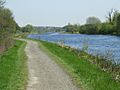
The Forth and Clyde Canal Pathway is a fantastic route for walking and cycling across Scotland. It stretches for 106-kilometre-long (66 mi) (about 66 miles) from Bowling, west of Glasgow, all the way to Lochrin Basin in Edinburgh. This path follows the old towpaths of the Forth & Clyde and Union Canals. A towpath is a path beside a canal, originally used by horses to pull boats.
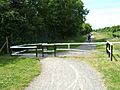
This pathway is completely off-road, making it a safe and enjoyable route. It's usually well-kept, but some parts, especially near Falkirk and Edinburgh, can get muddy when it rains. This might make it tricky for road bikes. The path is very popular with walkers and cyclists. It's even recognized as one of Scotland's Great Trails by NatureScot. It's also part of the National Cycle Network, known as Route 754.
Experts suggest starting your journey from the Clyde (west) and heading towards the Forth (east). This is because the wind usually blows from the southwest, giving you a helpful push. Some parts of the path are also good for experienced horseriders. However, some low bridges, narrow aqueducts, and gates might make it hard for horses to pass.
Contents
Exploring the Forth and Clyde Canal Pathway
.jpg)
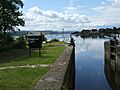
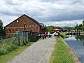
Let's take a journey along the path from west to east. It starts at Bowling Basin, where the Forth & Clyde Canal meets the Firth of Clyde. The canal then heads east through towns like Clydebank and Maryhill. Along the way, you'll see many locks, which are like water elevators that help boats move between different water levels.
Near Maryhill, you'll find Stockingfield Junction. From here, a special branch of the canal once connected to the Monkland Canal, leading towards the center of Glasgow.
The path continues northeast through places like Bishopbriggs and Kirkintilloch. It eventually reaches the amazing Falkirk Wheel. This giant rotating boat lift connects the Forth & Clyde Canal with the Union Canal. Another branch of the Forth & Clyde Canal goes from Falkirk to the River Carron near Grangemouth.
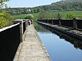
The journey continues along the Union Canal's towpath. This canal is different because it's a "contour canal." This means it mostly follows the natural shape of the land, so it doesn't need many locks. In fact, there's only one lock on the Union Canal, close to the Falkirk Wheel.
You'll pass through Linlithgow and see red shale "bings." These are huge piles of waste from Scotland's old oil shale industry. The path then goes through the outskirts of Edinburgh.
The pathway officially ends at Lochrin Basin, also known as Edinburgh Quay. This is right in the center of Edinburgh. If you want to explore more, you can extend your walk or ride for another 3 km (about 2 miles) through Edinburgh's center down to Leith and its docks.
You can easily reach the pathway by train. Bowling Station is near the start of the path. In Glasgow, both main train stations are close by. The railway line from Bowling to Glasgow passes through Glasgow Central Station. Another line runs close to the rest of the path, connecting Glasgow Queen Street Station to Edinburgh Haymarket Station. Stations in Croy, Falkirk, and Linlithgow are also just a short walk from the canal. Edinburgh's Waverley and Haymarket Stations are close to Lochrin Basin.
Many people like to complete the path in three roughly equal sections:
- Bowling Basin (near Bowling Station) to Auchinstarry Basin, Kilsyth (near Croy Station)
- Auchinstarry Basin to Linlithgow Canal Centre (near Linlithgow Station)
- Linlithgow Canal Centre to Lochrin Basin (near Haymarket and Waverley Stations)
Amazing Sights Along the Path

The Forth and Clyde Canal Pathway offers many interesting sights:
- The Slateford Aqueduct on the edge of Edinburgh carries the canal over the Water of Leith.
- The Avon Aqueduct, west of Linlithgow, is 250 m (810 ft) (about 247 meters) long and 26 m (86 ft) (about 26 meters) high. It's the second-largest aqueduct in Britain!
- Near Broxburn on the Union Canal, you'll see those red shale "bings" again. These are leftovers from Scotland's early oil industry. A chemist named James 'Paraffin' Young started extracting oil from shale here. This industry once employed 10,000 people!
- The Almond Aqueduct is west of Ratho. It lifts the canal 23 m (75 ft) (about 23 meters) above the River Almond.
- The Falkirk Wheel is a true engineering marvel. It helps boats move between the Forth & Clyde and Union canals. It replaced eleven old locks that used to lift boats 110 ft (34 m) (about 33.5 meters) between the two canals.
- The Falkirk Tunnel is Scotland's oldest and longest canal tunnel. It's 631 meters (about 2,070 feet) long, 5.5 meters (18 feet) wide, and 6 meters (20 feet) high.
- The town of Kilsyth is worth a visit, with its Colzium estate and park.
- You can also see parts of the Antonine Wall, an ancient Roman fortification. Look for it at Bar Hill Fort near Twechar.
- The Kelvin Aqueduct in Glasgow is 120 m (400 ft) (about 122 meters) long and 21 m (70 ft) (about 21 meters) high.
Other Ways to Cross Scotland
Besides the Forth and Clyde Canal Pathway, there are other routes to cross central Scotland.
- Sustrans has created Route 75. This route starts at Gourock on the Firth of Clyde and goes to Bell's Bridge in Glasgow, passing through Paisley. It then continues to Edinburgh via Airdrie, the Bathgate Railway Path, the Water of Leith Walkway, and part of the Union Canal towpath. This route is longer, at 171 mi (275 km) (about 275 km), and only about 98 mi (158 km) (158 km) of it is off-road.
- Another option is the John Muir Way. This path runs from Dunbar to Helensburgh, covering a distance of 215 km (215,000 m) (about 134 miles). It includes a section along the Forth and Clyde Canal and is also one of Scotland's Great Trails.
Images for kids
-
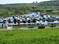
Auchinstarry Basin
-
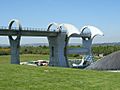
Falkirk Wheel
-
Avon Aqueduct
-
Union Canal
-
Bowling Basin
-
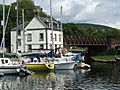
Bowling Basin
-
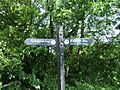
Forth & Clyde signpost
-
Union Canal
-
Forth & Clyde Lock 27
-
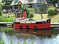
Forth & Clyde
-
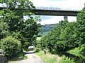
Under the Erskine Bridge


