Fortress Mountain (Washington) facts for kids
Quick facts for kids Fortress Mountain |
|
|---|---|

Fortress Mountain
|
|
| Highest point | |
| Elevation | 8,671 ft (2,643 m) |
| Prominence | 1,680 ft (510 m) |
| Isolation | 5.49 mi (8.84 km) |
| Parent peak | Seven Fingered Jack |
| Geography | |
| Location | Washington, United States |
| Parent range | Cascade Range |
| Topo map | USGS Suiattle Pass |
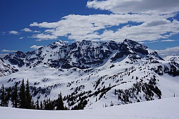
Fortress Mountain is a tall mountain peak in the Cascade Range in Washington, United States. It stands about 8,671-foot (2,643 m) high. The mountain is located about 15 miles (24 km) west of Lake Chelan. It sits on the border between Chelan and Snohomish Counties.
Fortress Mountain is part of the Mount Baker-Snoqualmie National Forest and the Wenatchee National Forest. It is also found within the Glacier Peak Wilderness area. This mountain is the highest point on Chiwawa Ridge. Other important peaks on this ridge include Napeequa Peak, Buck Mountain, and Chiwawa Mountain.
Contents
How Mountains Formed
The Glacier Peak Wilderness area, where Fortress Mountain is located, has very rugged land. You can see sharp peaks, long ridges, and deep valleys carved by glaciers. These different shapes and heights were created by geological events over millions of years. These events also led to the many climate differences in the Cascade Range.
Earth's Moving Plates
The Cascade Mountains began to form millions of years ago. This happened during a time called the late Eocene Epoch. The North American Plate (a huge piece of Earth's outer layer) slowly moved over the Pacific Plate. This movement caused many periods of volcanic activity.
Small pieces of Earth's crust, called terranes, also played a part. These pieces came together to form the North Cascades about 50 million years ago.
Glaciers and Uplift
About two million years ago, during the Pleistocene period, glaciers repeatedly moved across the land. As they advanced and then melted back, they scraped and shaped the landscape. They left behind piles of rock debris.
The "U"-shaped valleys you see today were formed by these glaciers. The process of land rising (called uplift) and cracks in the Earth's crust (called faulting) worked with the glaciers. Together, they created the tall peaks and deep valleys of the North Cascades area.
Mountain Weather
Most weather fronts, which bring changes in weather, start over the Pacific Ocean. They then travel east towards the Cascade Range. As these weather fronts get closer to the mountains, the peaks force the air upward. This process is called Orographic lift.
When the air rises, it cools down and drops its moisture. This moisture falls as rain or snow onto the Cascades. Because of this, the Cascade Mountains get a lot of rain and snow, especially in winter.
Summer vs. Winter
During the winter, the weather is usually cloudy. However, in the summer, high-pressure systems often form over the Pacific Ocean. These systems make the weather clearer. This means there is often little or no cloud cover during the summer months. The best time to visit or climb Fortress Mountain is usually from July through September.
 | Calvin Brent |
 | Walter T. Bailey |
 | Martha Cassell Thompson |
 | Alberta Jeannette Cassell |


