Napeequa Peak facts for kids
Quick facts for kids Napeequa Peak |
|
|---|---|

Napeequa Peak
|
|
| Highest point | |
| Elevation | 8,073 ft (2,461 m) |
| Prominence | 1,273 ft (388 m) |
| Parent peak | Buck Mountain 8528 ft |
| Geography | |
| Parent range | North Cascades Cascade Range |
| Topo map | USGS Clark Mountain |
| Geology | |
| Age of rock | Cretaceous |
| Type of rock | Granodiorite |
| Climbing | |
| Easiest route | Scrambling |
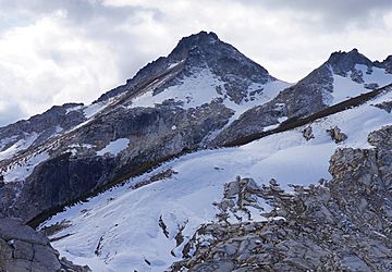
Napeequa Peak is a tall, pyramid-shaped mountain in Washington state. It stands 8,073-foot (2,461-metre) high. This peak is located in the Glacier Peak Wilderness area. It is part of the North Cascades mountain range.
This mountain is part of the Cascade Range. It sits right on the border between Snohomish and Chelan counties. It's also found where two big forests meet: the Mount Baker-Snoqualmie National Forest and the Wenatchee National Forest. Its closest mountain neighbor is Cirque Mountain, just a short distance north. The nearest taller mountain is Buck Mountain, a few miles to the east.
Rain and melting snow from the peak flow into two rivers. Some water goes east to the Napeequa River. Other water flows west into the Suiattle River. The mountain's name comes from the Napeequa River. A pioneer surveyor named Albert Hale Sylvester gave the river its name. He explored and mapped parts of the Cascades.
How the Mountains Were Formed
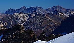
The North Cascades mountains have very rugged shapes. You can see sharp peaks, long ridges, and deep valleys carved by glaciers. These amazing shapes were created by geological events over millions of years. These events caused big changes in elevation across the Cascade Range. This also led to different climates in various areas.

The Cascade Mountains started forming millions of years ago. This was during a time called the late Eocene Epoch. The North American Plate (a huge piece of Earth's crust) slowly moved over the Pacific Plate. This movement caused volcanoes to erupt many times. Also, small pieces of Earth's crust, called terranes, joined together. This helped create the North Cascades about 50 million years ago.
During the Pleistocene period, which was over two million years ago, glaciers grew and shrank many times. These huge ice sheets carved and shaped the land. Glaciers were biggest about 18,000 years ago. Most valleys were free of ice by 12,000 years ago. The land pushing up (uplift) and cracks in the Earth (faulting) worked with the glaciers. Together, they made the tall peaks and deep valleys we see today.
Volcanic activity in this area began about 90 million years ago. More widespread volcanic eruptions started about 35 million years ago. Glacier Peak, a large volcano, began forming in the mid-Pleistocene. It is about 6.59 mi (10.61 km) west of Napeequa Peak. Because Glacier Peak is so close, you can often find volcanic ash in the area.
Mountain Weather and Climate
Napeequa Peak is in a marine west coast climate zone. This means it gets a lot of moisture from the ocean. Most weather systems start in the Pacific Ocean. They then travel northeast towards the Cascade Range.
As these weather systems reach the North Cascades, the tall peaks force the air upward. This process is called Orographic lift. When the air rises, it cools down and drops its moisture. This causes a lot of rain or snow to fall on the Cascades. The western side of the North Cascades gets a lot of precipitation. This is especially true during the winter months, when heavy snowfall is common.
During winter, the weather is usually cloudy. But in summer, high-pressure systems over the Pacific Ocean get stronger. This often leads to clear skies with little or no cloud cover. Because of the ocean's influence, the snow here tends to be wet and heavy. This type of snow can increase the danger of avalanches.
 | Delilah Pierce |
 | Gordon Parks |
 | Augusta Savage |
 | Charles Ethan Porter |


