
Chiwawa Mountain facts for kids
Quick facts for kids Chiwawa Mountain |
|
|---|---|

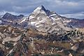
Chiwawa Mountain from north
|
|
| Highest point | |
| Elevation | 8,459 ft (2,578 m) |
| Prominence | 1,219 ft (372 m) |
| Parent peak | Fortress Mountain 8760 ft |
| Geography | |

Chiwawa Mountain
Location in Washington (state)

Chiwawa Mountain
Location in the United States
|
|
| Parent range | North Cascades Cascade Range |
| Topo map | USGS Suiattle Pass |
| Geology | |
| Age of rock | Cretaceous |
| Type of rock | Biotite gneiss |
| Climbing | |
| First ascent | 1921 party of The Mountaineers led by Lorenz A. Nelson |
| Easiest route | Scrambling |
Chiwawa Mountain is a tall mountain in Washington state, standing at 8,459 feet (about 2,578 meters) high. It's found in a wild, beautiful area called the Glacier Peak Wilderness, which is part of the North Cascades mountain range.
This mountain sits right on the top ridge of the Cascade Range. It marks the border between two counties, Snohomish and Chelan. It also divides two big forests: the Mount Baker-Snoqualmie National Forest and the Wenatchee National Forest. Its closest taller neighbor is Fortress Mountain, which is about 1.12 miles (1.8 kilometers) to the west.
Chiwawa Mountain is special because it's a "triple divide peak." This means that rain and melting snow from its slopes flow in three different directions! Some water goes northeast towards Lake Chelan, some flows northwest into the Suiattle River, and some goes south into the Chiwawa River. The mountain's name comes from the Chiwawa River. A pioneer surveyor named Albert Hale Sylvester gave it this name. "Chiwawa" comes from the Columbia-Moses language and means a type of creek.
Contents
Mountain Formation
Chiwawa Mountain is part of a large underground rock formation called the Cloudy Pass batholith. This formation was created about 20 million years ago when hot, melted rock pushed its way up into the Earth's crust and then cooled.
Ice Age Impact
During the Pleistocene period, which started over two million years ago, huge sheets of ice called glaciers moved across the land many times. These glaciers carved and shaped the mountains and valleys we see today. You can still see parts of the Lyman Glacier on the northeast side of Chiwawa Mountain.
The glaciers were biggest about 18,000 years ago. Most valleys were free of ice by 12,000 years ago. The combination of the land pushing upwards (called uplift) and cracks in the Earth's crust (called faulting) along with the glaciers, created the tall peaks and deep valleys of the North Cascades.
Volcanic Activity
About 90 million years ago, during the late Cretaceous period, the Earth's plates started moving and colliding in this area. This led to a lot of volcanic activity starting about 35 million years ago. Glacier Peak, a large volcano, began forming in the middle of the Pleistocene period. It's only about 10 miles (16 kilometers) southwest of Chiwawa Mountain. Because Glacier Peak is so close, you can often find volcanic ash in the area around Chiwawa Mountain.
Weather and Climate
Chiwawa Mountain is in a "marine west coast" climate zone. This means it's influenced by the nearby Pacific Ocean. Most weather systems start over the Pacific Ocean and move northeast towards the Cascade Range.
Rain and Snow
When these weather systems hit the tall peaks of the Cascades, they are forced to rise. As the air rises, it cools and drops its moisture as rain or snow. This process is called Orographic lift. Because of this, the western side of the North Cascades gets a lot of precipitation, especially heavy snowfall in the winter.
Temperatures and Seasons
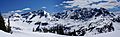
Thanks to the ocean's influence, the areas west of the Cascade mountain range rarely get extremely cold (below 0°F or -18°C) or extremely hot (above 80°F or 27°C). In winter, it's often cloudy. However, during the summer, high-pressure systems over the Pacific Ocean usually bring clear skies. The snow here tends to be wet and heavy, which can increase the danger of avalanches.
Images for kids
-
Chiwawa Mountain
-
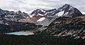
Chiwawa Mountain and Lyman Lake
-
Chiwawa Mountain (left) with its parent, Fortress Mountain (right)


See also
 In Spanish: Montaña Chiwawa para niños
