
Frisco Mountain facts for kids
Quick facts for kids Frisco Mountain |
|
|---|---|

Frisco Mountain seen from the North Cascades Highway
|
|
| Highest point | |
| Elevation | 7,760 ft (2,365 m) |
| Prominence | 485 ft (150 m) |
| Isolation | 0.54 mi (0.87 km) |
| Geography | |

Frisco Mountain
Location in Washington (state)

Frisco Mountain
Location in the United States
|
|
| Location | Chelan, Washington, United States |
| Parent range | North Cascades |
| Topo map | USGS McGregor Mountain |
| Climbing | |
| First ascent | 1926, Lage Wernstedt |
| Easiest route | Scrambling |
Frisco Mountain is a mountain peak in the Cascade Range in Washington, USA. It stands about 7,760 feet (2,365 meters) tall. This mountain is found near Rainy Pass, which is a mountain pass.
Frisco Mountain is located on the edge of the Stephen Mather Wilderness and North Cascades National Park. Its name comes from a mining claim that was active in the 1920s. The closest taller peak is Rainy Peak, which is about 0.54 miles (0.87 km) away.
Water from Frisco Mountain flows into Rainy Lake and other streams. There's a glacier called the Lyall Glacier on the mountain's northeast side. As this glacier melts, it creates waterfalls that drop about 1,000 feet into Rainy Lake.
Mountain Weather and Climate
Frisco Mountain is in a marine west coast climate zone. This means it gets a lot of moisture from the Pacific Ocean. Most weather systems start over the Pacific and move towards the Cascade Range.
When these weather systems reach the North Cascades, the mountains force the air to rise. This process is called Orographic lift. As the air rises, it cools and drops its moisture as rain or snow. This is why the west side of the North Cascades gets a lot of rain and snow, especially in winter.
Winters are usually cloudy, with heavy, wet snow. This type of snow can lead to a high risk of avalanches. In summer, high-pressure systems over the Pacific often bring clear skies.
How Frisco Mountain Formed
The North Cascades area has very rugged land. You can see sharp peaks, long ridges, and deep valleys carved by glaciers. These features were created by geological events that happened millions of years ago.
The Cascade Range began forming millions of years ago, during the late Eocene Epoch. This was when the North American Plate started moving over the Pacific Plate. This movement caused a lot of volcanic activity.
Also, small pieces of the Earth's crust, called terranes, collided and joined together. This process helped create the North Cascades about 50 million years ago.
During the Pleistocene period, which was over two million years ago, glaciers repeatedly moved across the land. These glaciers carved out the landscape and left behind rock debris. The "U"-shaped valleys you see today were formed by these glaciers.
The main forces that created the tall peaks and deep valleys of the North Cascades are uplift (when land is pushed up) and faulting (when rocks break and move), combined with the action of glaciers.
Images for kids
-
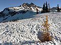
Frisco Mountain from the Maple Pass area

