
Rainy Peak facts for kids
Quick facts for kids Rainy Peak |
|
|---|---|

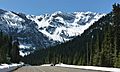
Rainy Peak seen from the North Cascades Highway near Rainy Pass
|
|
| Highest point | |
| Elevation | 7,768 ft (2,368 m) |
| Prominence | 1,288 ft (390 m) |
| Isolation | 2.33 mi (3.75 km) |
| Geography | |

Rainy Peak
Location in Washington (state)

Rainy Peak
Location in the United States
|
|
| Location | Chelan, Washington, United States |
| Parent range | North Cascades |
| Topo map | USGS McAlister Mountain |
| Climbing | |
| Easiest route | Scrambling |
Rainy Peak is a tall mountain peak in the Cascade Range in the state of Washington, USA. It stands 7,768 ft (2,368 m) high!
This peak is found about 3 kilometers (1.9 miles) south of Rainy Pass. It's also about one kilometer (0.62 miles) southeast of Frisco Mountain. Rainy Peak sits right on the edge of the Stephen Mather Wilderness and North Cascades National Park. The closest higher mountain is Corteo Peak, which is 2.33 mi (3.75 km) to the northwest.
Water from Rainy Peak flows into Rainy Lake and other small streams that feed into Bridge Creek. There's a glacier on the north side of the peak called the Lyall Glacier. This glacier is slowly shrinking, and its melting ice creates amazing waterfalls that drop 1,000 ft (300 m) into Rainy Lake!
Weather at Rainy Peak
Rainy Peak is in a special climate zone called the marine west coast climate. This means it gets a lot of moisture from the Pacific Ocean. Most weather fronts, which are like big air masses, start over the Pacific. They then travel east towards the Cascade Mountains.
When these weather fronts hit the North Cascades, the tall mountains force the air to rise. As the air goes up, it cools down and drops its moisture. This moisture falls as rain or snowfall onto the Cascades. Because of this, the western side of the North Cascades gets a lot of rain and snow, especially in winter.
During the winter, it's often cloudy. But in the summer, high pressure systems over the Pacific Ocean usually bring clear skies. The snow here tends to be wet and heavy because of the ocean's influence. This can sometimes lead to a high risk of avalanches.
How Rainy Peak Was Formed
The North Cascades mountains, where Rainy Peak is located, have very rugged shapes. You can see jagged peaks, sharp ridges, and deep valleys carved by glaciers. The way these mountains look today is because of amazing geological events that happened millions of years ago. These events created the different landscapes and huge changes in height across the Cascade Range. This also led to the different climates we see.
The story of the Cascade Mountains began millions of years ago, during the late Eocene Epoch. At that time, the North American Plate (a huge piece of Earth's crust) was slowly moving over the Pacific Plate. This movement caused many volcanic eruptions.
Also, small pieces of Earth's crust, called terranes, crashed into North America. These collisions helped build the North Cascades about 50 million years ago.
Later, during the Pleistocene period (which started over two million years ago), huge sheets of ice called glaciers moved across the land. These glaciers advanced and then melted back many times. As they moved, they scraped away the land, leaving behind piles of rock. The river valleys in the area are shaped like a "U" because of these glaciers.
The main forces that created the tall peaks and deep valleys of the North Cascades were:
- Uplift: When the land was pushed upwards.
- Faulting: When cracks formed in the Earth's crust, causing blocks of land to move.
- Glaciation: The powerful action of ice.

Images for kids
-
Rainy Peak from Rainy Pass

