
Corteo Peak facts for kids
Quick facts for kids Corteo Peak |
|
|---|---|

Corteo Peak seen from North Cascades Highway
|
|
| Highest point | |
| Elevation | 8,080 ft (2,460 m) |
| Prominence | 600 ft (180 m) |
| Isolation | 1.81 mi (2.91 km) |
| Parent peak | Black Peak (8,970 ft) |
| Geography | |

Corteo Peak
Location in Washington (state)

Corteo Peak
Location in the United States
|
|
| Location | Chelan County, Washington, U.S. |
| Parent range | North Cascades |
| Topo map | USGS Mount Arriva |
| Climbing | |
| First ascent | July 1935, John Lehmann and Hermann Ulrichs |
| Easiest route | Climb, class 4 |
Corteo Peak is a tall mountain, about 8,080 feet (2,463 meters) high. It sits right on the edge of the North Cascades National Park in Washington state. You can find it west of Rainy Pass, within the beautiful North Cascades mountain range.
Some parts of the Lewis Glacier are still there on its northern side, slowly melting away. The closest mountain that's even taller is Black Peak, which is about 1.67 miles (2.69 km) to the northwest. Corteo Peak and a nearby mountain, Mount Benzarino, got their names from a person named Lage Wernstedt. He was a surveyor for the Forest Service and named them after Basque sheepherders he met in the area.
Contents
Weather Around Corteo Peak
Corteo Peak is in a special climate zone called the marine west coast climate. This means it gets a lot of moisture from the Pacific Ocean. Most weather systems start over the Pacific and move northeast towards the Cascade Mountains.
How Mountains Affect Weather
When these weather systems hit the North Cascades, the mountains force the air to rise. As the air goes higher, it cools down and drops its moisture. This causes a lot of rain or snowfall on the western side of the Cascades. This process is called Orographic lift.
Seasons and Snow
Because of this, the western side of the North Cascades gets a lot of precipitation, especially snow in winter. Winters are usually cloudy. However, during summer, high-pressure systems over the Pacific Ocean often bring clear skies. The snow here tends to be wet and heavy due to the ocean's influence. This can sometimes lead to a high risk of avalanches.
How the Mountains Formed
The North Cascades are known for their rugged look. They have sharp peaks, long ridges, and deep valleys carved by glaciers. The story of how the Cascade Mountains formed goes back millions of years.
Plates and Volcanoes
Around 50 million years ago, the North American Plate was slowly moving over the Pacific Plate. This movement caused a lot of volcanic activity. Also, small pieces of the Earth's crust, called terranes, came together to create the North Cascades.
Ice and Erosion
During the Pleistocene period, which was over two million years ago, huge glaciers repeatedly moved across the land. These glaciers scraped and shaped the landscape, leaving behind piles of rock. The "U"-shaped valleys you see today were formed by these glaciers. The combination of the land pushing up (called uplift) and cracks in the Earth's crust (called faulting), along with the glaciers, created the tall peaks and deep valleys of the North Cascades.
Images for kids
-
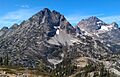
Corteo Peak and Black Peak (right) seen from Maple Pass loop trail
-
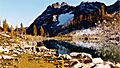
Corteo Peak seen from Wing Lake


