
Mount Benzarino facts for kids
Quick facts for kids Mount Benzarino |
|
|---|---|

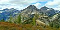
Benzarino's east aspect seen from Maple Pass Trail
|
|
| Highest point | |
| Elevation | 7,760 ft (2,370 m) |
| Prominence | 720 ft (220 m) |
| Isolation | 1.66 mi (2.67 km) |
| Parent peak | Corteo Peak (8,080 ft) |
| Geography | |

Mount Benzarino
Location in Washington (state)

Mount Benzarino
Location in the United States
|
|
| Location | North Cascades National Park Chelan County, Washington, U.S. |
| Parent range | North Cascades |
| Topo map | USGS McGregor Mountain |
| Climbing | |
| First ascent | 1926, Lage Wernstedt |
| Easiest route | class 3 scrambling |
Mount Benzarino is a 7,760+ ft (2,370+ m) mountain in North Cascades National Park. It is located in Chelan County, Washington state. This mountain is part of the North Cascades mountain range.
The closest taller mountain is Corteo Peak, which is about 1.67 miles (2.69 km) away to the northeast. Black Peak is also nearby, about 2.34 miles (3.77 km) to the north. A person named Lage Wernstedt, who worked as a surveyor for the Forest Service, gave Mount Benzarino and Corteo Peak their names. He named them after Basque shepherds he met near these mountains. Lage Wernstedt was also the first person to climb Mount Benzarino in 1926.
You can still see parts of a small glacier on the north side of the mountain. Water from the mountain flows into small streams that feed into Bridge Creek. Bridge Creek then flows into the Stehekin River.
Contents
Understanding the Climate Around Mount Benzarino
Mount Benzarino is located in a marine west coast climate zone. This means it gets a lot of moisture from the ocean. Most of the weather systems start over the Pacific Ocean. They then travel northeast towards the Cascade Mountains.
How Weather Affects the North Cascades
When these weather systems reach the North Cascades, the tall mountains force the air to rise. As the air goes higher, it cools down and drops its moisture. This process is called Orographic lift. It causes a lot of rain or snow to fall on the Cascades.
The North Cascades get a lot of precipitation, especially during winter. In winter, it's often cloudy. But in summer, high-pressure systems over the Pacific Ocean usually bring clear skies. Because of the ocean's influence, the snow here is often wet and heavy. This can lead to a high risk of avalanches.
Exploring the Geology of the North Cascades
The North Cascades area has very rugged land. It features sharp peaks, long ridges, and deep valleys carved by glaciers. The Cascade Range started forming millions of years ago, during the late Eocene Epoch.
How Mountains and Valleys Formed
The North American Plate is slowly moving over the Pacific Plate. This movement caused many volcanic eruptions over time. Also, small pieces of the Earth's crust, called terranes, joined together to create the North Cascades about 50 million years ago.
During the Pleistocene period, which was over two million years ago, glaciers moved across the land many times. As they moved, they scraped away rock and left behind debris. The river valleys in this area have a "U" shape. This shape was created by these recent glaciers. The combination of land being pushed up (uplift) and cracks in the Earth's crust (faulting) along with glaciation has shaped the tall peaks and deep valleys of the North Cascades.
Images for kids
-
View from Maple Pass Trail with Benzarino (left), Corteo Peak (center), and Black Peak (right)
-
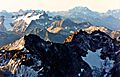
Mt. Benzarino in lower half of frame, seen from Black Peak. Note small glacier below summit. (McGregor Mountain in upper left)


