
McGregor Mountain (Washington) facts for kids
Quick facts for kids McGregor Mountain |
|
|---|---|

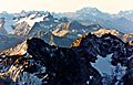
Southeast aspect, from Stehekin
|
|
| Highest point | |
| Elevation | 8,122 ft (2,476 m) |
| Prominence | 2,122 ft (647 m) |
| Isolation | 7 mi (11 km) |
| Geography | |

McGregor Mountain
Location in Washington (state)

McGregor Mountain
Location in the United States
|
|
| Location | Chelan County, Washington, US |
| Parent range | Cascade Range North Cascades Methow Mountains |
| Topo map | USGS McGregor Mountain |
| Type of rock | Skagit gneiss |
| Climbing | |
| Easiest route | Scrambling southwest ridge |
McGregor Mountain is a tall mountain, standing 8,122 feet (2,476 meters) high. It is located in the Stehekin Valley within the North Cascades mountain range in Chelan County, Washington state.
This mountain sits northwest of Lake Chelan in the northern Methow Mountains. It is right on the edge of North Cascades National Park and the Lake Chelan National Recreation Area. The closest town is Stehekin. The nearest taller mountain is Goode Mountain, about 7.3 miles (11.7 km) away to the northwest.
Water from McGregor Mountain flows into small streams that feed the Stehekin River. The southern side of the mountain rises steeply, climbing 6,600 feet (2,012 meters) from the river in just about two miles. This shows how dramatic the landscape is!
The famous Pacific Crest Trail passes along the western base of McGregor Mountain. There's also a challenging 7.7-mile (12.4 km) trail called the McGregor Mountain Trail. It gains 6,400 feet (1,920 meters) in height and takes hikers very close to the top.
Reaching the very summit means doing some exposed scrambling (climbing over rocks using hands and feet) for the last 1,100 feet (330 meters). If there's still snow, you might need an ice axe to help you climb safely.
From 1923 to 1955, there was a fire lookout cabin on the summit. Today, a radio repeater for the National Park Service stands there instead. The views from the top are amazing! You can see many other peaks like Glacier Peak, Black Peak, Corteo Peak, Frisco Mountain, Tupshin Peak, Dome Peak, and Glory Mountain.
The mountain was named after Billy McGregor. He lived in the Stehekin Valley in the 1890s and had a cabin and homestead at the base of this mountain. Sadly, in May 1901, Billy disappeared from a boat on Lake Chelan and was never seen again.
Weather and Climate at McGregor Mountain
McGregor Mountain has an alpine climate, which means it's cold and snowy, similar to what you'd find high up in the Alps. This climate helps support the Sandalee Glacier on the mountain's northern slopes.
Most of the weather systems that affect this area start in the Pacific Ocean. They travel northeast towards the Cascade Range. As these weather fronts get closer to the North Cascades, the tall mountains force the air to rise. When the air rises, it cools down and drops its moisture as rain or snow onto the Cascades. This process is called Orographic lift.
Because of this, the North Cascades gets a lot of rain and especially a lot of snow, particularly during the winter months. In winter, the weather is often cloudy. However, during the summer, high-pressure systems over the Pacific Ocean become stronger. This often leads to clear skies and little to no cloud cover.
How McGregor Mountain Was Formed

The North Cascades area has some of the most rugged and dramatic landscapes in the Cascade Range. You'll find jagged peaks, sharp ridges, deep valleys carved by glaciers, and tall, pointed rock formations made of granite.
The amazing landscape and big changes in elevation you see today were created by geological events that happened millions of years ago. These events also led to different climates in various parts of the Cascade Range, which in turn created different types of plant life and ecoregions.
The story of how the Cascade Mountains formed goes back millions of years, to a time called the late Eocene Epoch. During this time, the North American Plate (a huge piece of Earth's crust) was slowly moving over the Pacific Plate. This movement caused many episodes of volcanic activity, where molten rock erupted from the Earth.
Also, small pieces of Earth's crust, called terranes, crashed into and joined the North American continent. These collisions helped build up the North Cascades about 50 million years ago.
Over the past two million years, during the Pleistocene period, huge sheets of ice called glaciers repeatedly moved across the land. As they advanced and retreated, they scraped and shaped the landscape, leaving behind piles of rock debris. The U-shaped valleys you see today were carved out by these glaciers.
The main forces that created the tall peaks and deep valleys of the North Cascades are uplift (when land is pushed upwards) and faulting (when cracks in the Earth's crust cause blocks of land to move), combined with the powerful action of glaciers.
Images for kids
-
The Sandalee Glacier and McGregor Mountain in the upper left (Mount Benzarino is in the lower part of the picture)
-
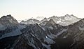
McGregor Mountain in the upper right

.jpg)
