
Glory Mountain facts for kids
Quick facts for kids Glory Mountain |
|
|---|---|

Glory Mountain left, Halleluja Peak right
|
|
| Highest point | |
| Elevation | 7,228 ft (2,203 m) |
| Prominence | 1,348 ft (411 m) |
| Geography | |

Glory Mountain
Location in Washington (state)

Glory Mountain
Location in the United States
|
|
| Parent range | North Cascades |
| Topo map | USGS Goode Mountain |
| Type of rock | Gneiss |
| Climbing | |
| Easiest route | Scrambling |
Glory Mountain is a tall mountain in the North Cascades Range in Chelan County, Washington state. It stands about 7,228 feet (2,203 meters) high.
This mountain is located southeast of Trapper Lake. It sits right on the edge of North Cascades National Park and Glacier Peak Wilderness. The closest mountain that is taller than Glory Mountain is Trapper Mountain, which is about 1.72 miles (2.77 km) to the west.
Water from Glory Mountain flows into Cottonwood Creek and Flat Creek. Both of these creeks eventually join the Stehekin River. There is also a smaller peak nearby, unofficially called Halleluja Peak. It is about 7,120 feet (2,170 meters) tall and lies about 0.32 miles (0.51 km) west of Glory Mountain's main summit.
Climate and Weather
Glory Mountain is in a special weather area called the marine west coast climate zone. This means it gets a lot of moisture from the Pacific Ocean. Most of the weather systems, like big clouds and storms, start over the Pacific Ocean. They then travel northeast towards the Cascade Mountains.
When these weather systems reach the North Cascades, the tall mountains force the air to rise. As the air goes higher, it cools down and drops its moisture. This moisture falls as rain or snow onto the mountains. This process is called Orographic lift. Because of this, the western side of the North Cascades gets a lot of rain and snow, especially in winter.
During the winter, it's often cloudy. But in the summer, big areas of high pressure over the Pacific Ocean usually bring clear skies. This means you can often see the mountain clearly during the warmer months.
How the Mountains Formed
The North Cascades are known for their very rugged and dramatic landscape. They have sharp, rocky peaks, long ridges, and deep valleys carved by glaciers. There are also tall, pointed rock formations made of granite.
The amazing shapes of these mountains and the big changes in elevation happened over millions of years. These geological events also led to different climates in various parts of the range. These climate differences then created many different types of plant and animal ecoregions in the area.
The story of how the Cascade Mountains formed goes back millions of years. Around 50 million years ago, during the late Eocene Epoch, the North American Plate was slowly moving over the Pacific Plate. This movement caused many volcanic eruptions and other fiery rock activity.
Also, small pieces of the Earth's outer layer, called terranes, crashed into the North American continent. These pieces were made of both oceanic and continental rock. These collisions helped build up the North Cascades about 50 million years ago.
Later, during the Pleistocene period, which started over two million years ago, huge sheets of ice called glaciers covered the land. These glaciers moved forward and then melted back many times. As they moved, they scraped away the land, leaving behind piles of rock. The U-shaped valleys you see in the mountains today were carved out by these powerful glaciers.
The combination of the land being pushed up (called uplift) and cracks forming in the Earth's crust (called faulting), along with the work of glaciers, created the tall peaks and deep valleys of the North Cascades.
- Glory Mountain weather forecast
Images for kids
-
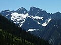
Glory Mountain (left) and Halleluja Peak (right)
-
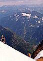
Glory Mountain seen from Sahale Peak
-
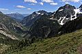
Glory Mountain (center) from Cascade Pass-Sahale Arm


