
Frontier Strip facts for kids

The Frontier Strip is a name for six states in the United States. These states form a long line from north to south. They stretch all the way from North Dakota down to Texas.
Contents
What is the Frontier Strip?
The idea of the Frontier Strip comes from the 1880 census. A census is a count of people and information about them. At that time, these six states, or parts of them, were seen as the "Frontier Line." This line was often thought to be near the 100th meridian west. This is an imaginary line on maps.
The U.S. Census Bureau used this line to show where the settled parts of the Eastern United States ended. It also showed where the wilder, historic American Wild West began. By the 1890 census, the idea of a clear "frontier line" was gone. This was because settlements had spread out too much.
States in the Frontier Strip
The Frontier Strip covers a large area of land. It is about 16.75% of all U.S. land. In the year 2000, about 30 million people lived there. This was about 10.7% of the U.S. population. The population is much higher in the southern parts. Texas alone has most of the people in this region.
The modern states that make up the Frontier Strip are:
Politics in the Frontier Strip
The Frontier Strip has often voted for the Republican Party. This has been true for a long time. Even during the Great Depression, when many people voted for Democrats, these states often voted Republican.
However, Texas and Oklahoma were different for much of the 20th century. They were part of the "Solid South." This meant they usually voted for the Democratic Party. The last Democratic presidential candidate to win one of these six states was Jimmy Carter. He won Texas in the United States presidential election, 1976.
How the Region is Seen
Even though these states are next to each other, they are not always seen as one cultural region. They share a history from the frontier days. They also have many "western" traits. But Texas and Oklahoma are often grouped with the South or Southwest. The states to the north are usually seen as part of the Midwest. None of them are considered part of the West by the U.S. Census Bureau today.
Climate and Weather
The weather in the Frontier Strip changes a lot. It is different from north to south and from east to west. In the northern states, summers are warm and winters are cold. This is called a humid-continental climate. In the southern states, summers are hot and winters are mild. This is a humid-subtropical climate.
The far western parts of all these states are semi-arid. This means they get very little rain. However, temperatures can still vary a lot from north to south.
One of the most famous things about the weather here is the violent storms. Many of these states are part of what is called Tornado Alley. This area is known for having the most tornadoes in the world. Warm, wet air from the southeast mixes with cold air from Canada or the western U.S. This, along with a "dry line" (a boundary between dry and moist air), creates perfect conditions for tornadoes. Kansas, Oklahoma, and Texas alone have about one-third of all tornadoes recorded in the United States. They are often called the "heart of Tornado Alley."
Images for kids
-
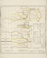
Map of Indian territory in 1836, showing lands set aside for Native American tribes.
-
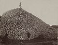
A pile of American bison skulls from the 1870s. These were often ground into fertilizer.
-
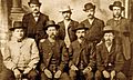
Wyatt Earp, Bat Masterson, and others on the Dodge City Peace Commission. They helped keep peace in the Old West.
-
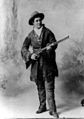
Calamity Jane at age 33. She was a famous frontierswoman.
-
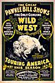
A poster for The Great Pawnee Bill shows from around 1903. These shows featured Wild West acts.
-
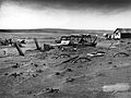
A farm in South Dakota during the Dust Bowl in 1936. This was a time of severe dust storms.


