
Güttingen facts for kids
Quick facts for kids
Güttingen
|
||
|---|---|---|
 |
||
|
||

Güttingen
Location in Switzerland

Güttingen
Location in Canton of Thurgau
|
||
| Country | Switzerland | |
| Canton | Thurgau | |
| District | Kreuzlingen | |
| Area | ||
| • Total | 9.54 km2 (3.68 sq mi) | |
| Elevation | 396 m (1,299 ft) | |
| Population
(Dec 2020 )
|
||
| • Total | 1,668 | |
| • Density | 174.84/km2 (452.8/sq mi) | |
| Postal code |
8594
|
|
| Surrounded by | Altnau, Hagnau am Bodensee (DE-BW), Immenstaad am Bodensee (DE-BW), Kesswil, Langrickenbach, Sommeri, Stetten (DE-BW) | |

Güttingen is a small town, also called a municipality, located in the Kreuzlingen area of Thurgau, a canton (like a state) in Switzerland. It's a cool place with a long history and beautiful nature.
Contents
A Look Back in Time: Güttingen's History
Güttingen has been home to people for a very long time! The first signs of people living here are from the Stone Age, about 6,000 years ago. Later, during the Early Middle Ages, there was even an old burial ground from the Alamanni people.
How Güttingen Got Its Name
The town of Güttingen was first written about in the year 799. Back then, it was called Cutaningin. Later, in 1155, it was known as Guthingen.
Who Ruled Güttingen?
For many years, powerful groups owned most of the land in Güttingen. The Bishop of Constance and the Abbey of St. Gall were two of the main landowners. From 1159 to 1357, a noble family called the Freiherr of Güttingen also owned land and had control over the area.
Later, in 1359, the Lords of Breitenlandenberg took over. But in 1452, the Bishop of Constance got back his rights and property. The Bishop then appointed a special leader, called a chief bailiff, who lived in the castle and made decisions for the village until 1798.
By 1275, Güttingen already had a church. During the Protestant Reformation, many people in the village decided to follow the new Protestant faith. However, the Kreuzlingen Abbey kept the right to choose the church's priest until 1848.
Because of this, the village church became a shared church. This means that both Catholics and Protestants have used the same church building for their services ever since!
Güttingen's Economy Through the Years
For a long time, the people of Güttingen mostly worked in farming, shipping, and fishing. In the 1800s, farmers started focusing more on raising cattle and dairy farming. A dairy cooperative, where farmers work together, opened in 1861.
In the early 1900s, vineyards (where grapes are grown for wine) were replaced with fruit orchards. An agricultural cooperative was also started in 1920 to help farmers.
Even though a new road (the Seestrasse) was built in 1840 and a railway (the Seetalbahn) opened in 1870, they didn't bring much new business to Güttingen at first. However, some factories did open up. In 1835, a dye-works (a place that makes dyes for fabric) started operating. By 1900, an embroidery factory also moved into the town.
Today, Güttingen still has a lot of farming and a fruit trading company. But many people also work in other medium-sized businesses and industries.
Güttingen's Geography and Nature
Güttingen covers an area of about 9.49 square kilometers (about 3.66 square miles). A big part of this land, about 61.9%, is used for farming. Forests cover about 29.2% of the area, making it a very green place!
The rest of the land, about 9.0%, is where buildings and roads are. Only a tiny bit, 0.1%, is land that can't be used for anything.
What the Land is Used For
- Buildings and Roads: Most of the built-up area is for industrial buildings (4.5%), houses (0.6%), and roads (0.4%). There are also parks and sports fields (3.3%).
- Forests: About 27.3% of the land is covered by thick forests, and 1.9% has orchards or small groups of trees.
- Farming: Nearly half of the farming land (49.6%) is used for growing crops. The rest (12.2%) is for orchards or vineyards.
Güttingen is located in the Kreuzlingen district, only about 1 kilometer (0.6 miles) from Lake Constance. The main part of Güttingen is a haufendorf village. This means it's an old-fashioned village with an unplanned, close-packed layout, often built around a central square.
People of Güttingen: Demographics
Güttingen has a population of about 1,423 people (as of 2008). Over the last 10 years, the population has grown by about 4.7%.
Languages Spoken
Most people in Güttingen speak German, about 94.2% of the population. The next most common language is Albanian (2.6%), followed by Serbo-Croatian (0.8%).
Age Groups in Güttingen
Here's a look at the different age groups in Güttingen (as of 2009):
- Children (0-9 years): 10.8% of the population.
- Teenagers (10-19 years): 13.7% of the population.
- Young Adults (20-29 years): 10.8% of the population.
- Adults (30-59 years): This is the largest group, making up about 43.7% of the population.
- Seniors (60+ years): About 20.9% of the population.
Homes and Households
In 2000, there were 500 private homes in Güttingen, with about 2.6 people living in each home on average. Most of the buildings were single-family homes (84.7%).
Voting and Politics
In the 2007 federal election, the most popular political party in Güttingen was the SVP, which received almost half of the votes (48.47%). Other popular parties included the Green Party, the CVP, and the FDP. About 50.9% of eligible voters participated in this election.
Population Growth Over Time
Here's how Güttingen's population has changed over the years:
| year | population |
|---|---|
| 1850 | 780 |
| 1900 | 917 |
| 1950 | 970 |
| 1980 | 1,024 |
| 1990 | 1,102 |
| 2000 | 1,308 |
Güttingen's Economy Today
As of 2007, Güttingen had a low unemployment rate of 1.04%. This means most people who want to work can find jobs.
Types of Jobs
- Primary Sector: This includes jobs like farming and fishing. In 2005, about 135 people worked in this sector, with 39 businesses.
- Secondary Sector: This involves manufacturing and industry. About 185 people worked in this sector, with 31 businesses.
- Tertiary Sector: This includes service jobs, like shops, offices, and healthcare. About 208 people worked in this sector, with 44 businesses.
Many people who live in Güttingen also work outside the municipality. In 2000, about 46.4% of residents commuted to jobs in other towns. At the same time, 225 people traveled into Güttingen for work. Most people (43.8%) used a private car to get to work, while 11% used public transportation.
Religion in Güttingen
According to the 2000 census, the population of Güttingen has different religious beliefs:
- About 32.5% are Roman Catholic.
- About 46.2% belong to the Swiss Reformed Church (a Protestant church).
- Smaller groups include the Orthodox Church (0.46%) and other Christian churches (2.29%).
- About 6.04% of the population are Islamic.
- About 10.09% of people said they didn't belong to any church, or were agnostic or atheist.
Getting Around: Transport
Güttingen is located on the Lake Line, a railway line that connects Schaffhausen and Rorschach. The town has its own train station, Güttingen railway station, which is part of the St. Gallen S-Bahn network. This makes it easy for people to travel to and from Güttingen by train.
Learning and Education
Switzerland is known for its good education system, and Güttingen is no exception. About 75.7% of the adults in Güttingen (between ages 25 and 64) have completed either non-mandatory high school education or even higher education, like university or a specialized college (called a Fachhochschule). This shows that education is highly valued in the community.
Weather and Climate
Güttingen experiences a moderate climate. Between 1991 and 2020, the town had an average of 122.1 days with rain or snow each year. On average, it received about 950 millimeters (37.4 inches) of rain or snow annually.
The wettest month is usually June, with about 110 millimeters (4.3 inches) of rain or snow. February is typically the driest month, with about 53 millimeters (2.1 inches) of precipitation.
| Climate data for Güttingen (1991–2020) | |||||||||||||
|---|---|---|---|---|---|---|---|---|---|---|---|---|---|
| Month | Jan | Feb | Mar | Apr | May | Jun | Jul | Aug | Sep | Oct | Nov | Dec | Year |
| Mean daily maximum °C (°F) | 3.4 (38.1) |
5.0 (41.0) |
10.1 (50.2) |
14.7 (58.5) |
19.1 (66.4) |
22.6 (72.7) |
24.5 (76.1) |
24.1 (75.4) |
19.2 (66.6) |
13.7 (56.7) |
7.6 (45.7) |
4.0 (39.2) |
14.0 (57.2) |
| Daily mean °C (°F) | 1.0 (33.8) |
1.6 (34.9) |
5.5 (41.9) |
9.4 (48.9) |
13.7 (56.7) |
17.4 (63.3) |
19.1 (66.4) |
18.6 (65.5) |
14.4 (57.9) |
9.9 (49.8) |
5.0 (41.0) |
1.8 (35.2) |
9.8 (49.6) |
| Mean daily minimum °C (°F) | −1.6 (29.1) |
−1.5 (29.3) |
1.3 (34.3) |
4.2 (39.6) |
8.6 (47.5) |
12.2 (54.0) |
13.9 (57.0) |
13.8 (56.8) |
10.3 (50.5) |
6.6 (43.9) |
2.3 (36.1) |
−0.7 (30.7) |
5.8 (42.4) |
| Average precipitation mm (inches) | 55 (2.2) |
53 (2.1) |
60 (2.4) |
65 (2.6) |
100 (3.9) |
110 (4.3) |
108 (4.3) |
108 (4.3) |
79 (3.1) |
71 (2.8) |
67 (2.6) |
75 (3.0) |
950 (37.4) |
| Average snowfall cm (inches) | 10.6 (4.2) |
12.8 (5.0) |
4.1 (1.6) |
0.0 (0.0) |
0.0 (0.0) |
0.0 (0.0) |
0.0 (0.0) |
0.0 (0.0) |
0.0 (0.0) |
0.1 (0.0) |
3.6 (1.4) |
8.0 (3.1) |
39.2 (15.4) |
| Average precipitation days (≥ 1.0 mm) | 9.5 | 8.7 | 9.8 | 9.6 | 11.1 | 11.6 | 11.3 | 11.1 | 9.6 | 9.7 | 9.4 | 10.7 | 122.1 |
| Average snowy days (≥ 1.0 cm) | 3.6 | 3.4 | 1.7 | 0.0 | 0.0 | 0.0 | 0.0 | 0.0 | 0.0 | 0.0 | 1.2 | 2.8 | 12.7 |
| Average relative humidity (%) | 85 | 81 | 76 | 72 | 74 | 74 | 75 | 78 | 83 | 87 | 88 | 87 | 80 |
| Mean monthly sunshine hours | 44 | 75 | 141 | 182 | 201 | 218 | 238 | 217 | 157 | 92 | 48 | 37 | 1,650 |
| Percent possible sunshine | 18 | 28 | 41 | 47 | 45 | 48 | 52 | 52 | 45 | 30 | 19 | 16 | 40 |
| Source: MeteoSwiss (snow 1981–2010) | |||||||||||||
Images for kids
-
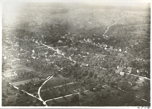
An aerial view of Güttingen and the area around it.

See also
 In Spanish: Güttingen para niños
