
Garraun (Galway) facts for kids
Quick facts for kids Garraun |
|
|---|---|
| Maolchnoc | |

The east faces of Garraun (left), and Benchoona (right), from across Lough Fee
|
|
| Highest point | |
| Elevation | 598 m (1,962 ft) |
| Prominence | 553 m (1,814 ft) |
| Listing | Marilyn, Arderin |
| Naming | |
| English translation | bald peak |
| Language of name | Irish |
| Geography | |

Garraun
Location in island of Ireland
|
|
| Location | Galway, Republic of Ireland |
| Parent range | Twelve Bens SAC |
| OSI/OSNI grid | L7670861036 |
| Topo map | OSi Discovery 37 |
| Geology | |
| Type of rock | Schists, grits, metavolcanics, mylonitic Bedrock |
Garraun (Irish: Maolchnoc, meaning bald hill) is a mountain in County Galway, Ireland. It stands at 598 metres (1,962 feet) tall. This makes it one of the higher peaks in Ireland.
Even though Garraun is just under 600 metres, it's still an important mountain. It's known as a "Marilyn" because it stands out a lot from the land around it. Garraun is located on its own group of mountains, called a massif. This area is near the entrance of Killary Harbour. It's part of the Twelve Bens/Garraun Complex Special Area of Conservation. This special area is found within the Connemara National Park in Galway. The southern side of Garraun offers beautiful views of Kylemore Abbey and Kylemore Lough.
What's in a Name?
Garraun has a few interesting names! An expert on Irish names, Paul Tempan, says that "Garraun" comes from an old Irish word. It could be from garrán, meaning "grove" (a small group of trees). Or, it might come from géarán, meaning "fang". Even though the top of the mountain is flat, its eastern ridge is quite sharp. This sharp ridge might be why it was called "fang".
Another expert, Tim Robinson, notes that Maolchnoc is a more common name for the mountain in the local area. Maolchnoc means "bald hill". This name fits the flat, bare top of Garraun very well. He thinks that An Géarán (the "fang" name) probably refers to the sharp eastern ridge that goes down to Lough Fee.
There's also a townland (a small land division) on the southern slopes of Garraun South Top. It's called "Lemnaheltia", which means "the doe's leap" in Irish. This name even appeared on an old map of Ireland from 1595!
A famous Irish legend is connected to this area. It tells the story of Fionn Mac Cumhail and his dog, Bran. Bran was chasing a doe here. The legend says the doe leapt from the top of the mountain. Sadly, Bran fell from the cliff into the lake below. Many places in Ireland have similar stories about Fionn and Bran.
Where is Garraun?
Garraun has a flat top and is part of its own mountain group. It sits near the entrance to Killary Harbour, which is Ireland's largest fjord (a long, narrow sea inlet with steep sides). The Garraun mountains are considered part of the famous Twelve Bens mountain range.
To the west of Garraun, you'll find other peaks:
- Garraun South Top is 556 metres (1,824 feet) high. It overlooks Kylemore Lough.
- Further west is Garraun South-West Top, which is 549 metres (1,801 feet) tall. Some maps call it "Altnagaighera", meaning "ravine of the sheep". This peak is known for its interesting rock formations called "Tors". These Tors are made of a type of rock called conglomerate.
Even further southwest, you'll see Doughruagh, which is 526 metres (1,726 feet) high. Its name, Dúchruach, means "black stack". This mountain is often seen in photos of Kylemore Abbey because it's right behind it. On the very steep southern side of Doughruagh, there's a statue of the Sacred Heart. It was put there in 1932 by the Benedictine nuns of Kylemore Abbey. They put it there to thank for their safe journey from Ypres in Belgium during World War One.
To the east of Garraun, there's a long, sharp ridge that goes down to Lough Fee. To the north of Garraun is Benchoona, which is 585 metres (1,919 feet) tall. Its name, Binn Chuanna, means "peak of Cuanna". Benchoona also has a smaller peak nearby called Benchoona East Top, at 581 metres (1,906 feet). The writer Robert Macfarlane once described Benchoona's top as a "rough broken tableland of flat rocks". He said it looked like it had been smoothed by ancient ice.
Garraun also has two other peaks nearby:
- To the east, across Lough Fee, is Letterettrin, 333 metres (1,093 feet) high. It's also called Binn Mhór, meaning "big peak".
- To the west is Currywongaun, 273 metres (896 feet) high. Its name, Corr Uí Mhongáin, means "Uí Mhongáin's round or pointed hill".
Hiking Garraun
Climbing Garraun can be a fun adventure! Here are some popular ways to hike it:
- The easiest way to climb Garraun is by following its sharp eastern ridge from Lough Fee. This hike is about 5 kilometres (3 miles) long and takes about 2.5 hours to go up and down. You can park your car at the unique Creeragh Church car park, which is just off the N59 road.
- Another great trail is the 9-kilometre (5.6 miles) Lettergesh Loop, also known as the Benchoona Horseshoe. This hike takes about 4 hours. It starts from Lettergesh Beach at the Carrickglass car park. The path goes to Cloonagh (Cluain Ard) and then loops around Benchoona, Garraun, and Garraun South-West Top (Altnagaighera) before returning to Cloonagh.
- There are also other routes, usually 8-10 kilometres (5-6 miles) long, which take 4-5 hours. These routes often include the top of Doughruagh and the shores of Kylemore Lough and Pollacappul Lough. They form a loop with Garraun and Altnagaighera.
Gallery
-
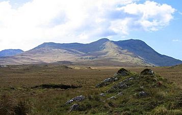
Garraun (left and centre) and Benchoona (right) as viewed from the N59 road in the east
-
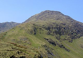
Summit of Benchoona viewed from the east
-
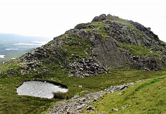
Garraun South-West Top (also called Altnagaighera)
-
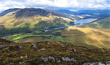
Doughruagh, Kylemore Abbey, and the Garraun massif behind, viewed from Diamond Hill


.jpg)

