
Gavar facts for kids
Gavar (Armenian: Գավառ [ɡɑˈvɑr]) is a town in Armenia. It is the main city of the Gavar Municipality and the Gegharkunik Province. Gavar is located among the tall Gegham mountains, west of Lake Sevan. It sits about 1,982 meters (6,503 feet) above sea level.
The town is about 98 kilometers (61 miles) east of Yerevan, the capital city. In 2011, Gavar had a population of 20,765 people. By 2016, the population was estimated to be around 19,500. Gavar is also the center for the Diocese of Gegharkounik of the Armenian Apostolic Church.
Quick facts for kids
Gavar
Գավառ
Kyavar • Քյավառ
|
||
|---|---|---|

|
||
|
||

Gavar
Location in Armenia

Gavar
Location in Gegharkunik
|
||
| Country | ||
| Province | Gegharkunik | |
| Municipality | Gavar | |
| Founded City status |
1830 1850 |
|
| Area | ||
| • Total | 16 km2 (6 sq mi) | |
| Elevation | 1,982 m (6,503 ft) | |
| Population
(2011)
|
||
| • Total | 20,765 | |
| • Density | 1,300/km2 (3,360/sq mi) | |
| Time zone | UTC+4 (AMT) | |
| Postal code |
1201-1205
|
|
| Area code(s) | (+374) 264 | |
| Vehicle registration | 02 | |
| Website | Official website: http://www.gavariqaghaqapetaran.am/ | |
| Gavar at GEOnet Names Server | ||

Contents
- What's in a Name? The History of Gavar's Names
- A Look Back: The History of Gavar
- Gavar's Location and Weather
- People and Faith in Gavar
- Culture and Traditions in Gavar
- Getting Around: Transportation in Gavar
- Gavar's Economy and Businesses
- Learning and Education in Gavar
- Sports in Gavar
- Gavar's International Connections
- Famous People from Gavar
- Images for kids
- See also
What's in a Name? The History of Gavar's Names
The town of Gavar has had a few different names over the years.
From Nor Bayazet to Kamo
- Until 1959, it was called Nor Bayazet (meaning New Bayazit). This name came from an older town called Bayazet in Western Armenia.
- Between 1959 and 1995, the town was known as Kamo. This name honored a revolutionary named Simon Ter-Petrosian.
Back to Gavar
- On December 4, 1995, the town was given its ancient name back: Gavar. In the Armenian language, Gavar means "county" or "region."
- Even today, many locals still call the town Kyavar (Քյավառ). This nickname has been used since the 1800s.
A Look Back: The History of Gavar


The modern town of Gavar was started in 1830. It was first called Novo-Bayazet (New Bayazit). This happened when 8,557 Armenians moved here from the town of Bayazit. They moved because of the Russo-Turkish war of 1828-1829. The new settlement became a town in 1850.
Ancient Roots of Gavar
- People have lived in the Gavar area since the Bronze Age, thousands of years ago.
- Many old tombstones from the 2nd millennium BC have been found here.
- On a hill in the town center, you can find the remains of a huge stone fort. This fort dates back to the early Iron Age.
- Experts believe this fort was the royal capital of a region called Uelikuhi, part of the ancient Urartu kingdom.
- The Urartian king Sarduri II conquered this region. Later, his son Rusa II renamed the fort after Ḫaldi, an important god. Gavar was then known as the "City of Khaldi."
- In 1927, ancient writings called cuneiform were found. They were made by Rusa II in 732 BC to celebrate his victory. These writings are now in Gavar's history museum.
- Another Iron Age fort, from the 2nd millennium BC, is in the Artsvakar area of Gavar.

Gavar in the Armenian Kingdom
- When the ancient Kingdom of Armenia was formed, Gavar was part of the Gegharkunik region. This region was in the northern part of the historic Syunik province of Armenia.
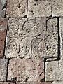
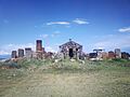
Monuments and Destruction
- Many old buildings and monuments are found in Gavar. These include monasteries, Khachkars (cross-stones), and old gravestones.
- The Hatsarat area, which used to be a separate village, has the Hatsarat Monastery. It has two churches, one from the 7th century and another from the 19th century.
.jpg)
- Over the centuries, Gavar was destroyed many times. One major destruction happened in the 17th century by Shah Abbas I of Persia.
- During the time of Iranian Armenia, Gavar was the center of the Gökcha mahal (a type of district) within the Erivan Khanate.
Under Russian and Soviet Rule
- In 1828, after the Russo-Persian War, the Gegharkunik region became part of the Russian Empire. This was due to the Treaty of Turkmenchay.
- In 1830, Armenian migrants from Bayazit founded the village of Novo-Bayazet.
- When the Erivan Governorate was created in 1850, Novo-Bayazet became the main town of the new Nor Bayazet uezd (a type of administrative district).

- Novo-Bayazet became part of the USSR in December 1920.
- In 1950, it became an urban-type settlement and grew. In 1959, it was renamed Kamo. By the early 1980s, it had 36,400 people.
Gavar After Armenian Independence
- After Armenia became independent in 1991, the town was renamed Gavar in 1995. It became the main city of the new Gegharkunik Province.
- However, many factories and old buildings from the Soviet era stopped working. This caused the population to drop. In 2001, it was 23,302, and in 2011, it was 20,765.
Gavar's Location and Weather
_34.jpg)
Gavar is about 1,982 meters (6,503 feet) above sea level. It is located on the banks of the Gavaraget river. The Gegham mountains are to its west, and Lake Sevan is to its east. Mount Azhdahak, which is 3,597 meters (11,801 feet) tall, is about 15 km (9 miles) southwest of Gavar.
Neighboring Villages
- Gavar is surrounded by several villages. These include Noratus to the east, and Karmirgyugh and Gandzak to the south.
Climate in Gavar
Gavar has a humid continental climate. This means it has cold winters and warm summers. The town gets about 450 mm (17.7 inches) of rain or snow each year.
| Climate data for Gavar 1961 m asl (1991–2020 normals, extremes 1981-2020) | |||||||||||||
|---|---|---|---|---|---|---|---|---|---|---|---|---|---|
| Month | Jan | Feb | Mar | Apr | May | Jun | Jul | Aug | Sep | Oct | Nov | Dec | Year |
| Record high °C (°F) | 10.6 (51.1) |
11.9 (53.4) |
18.6 (65.5) |
25.1 (77.2) |
27.6 (81.7) |
30.5 (86.9) |
32.7 (90.9) |
34.1 (93.4) |
31.1 (88.0) |
24.5 (76.1) |
20.6 (69.1) |
14.0 (57.2) |
34.1 (93.4) |
| Mean daily maximum °C (°F) | −0.6 (30.9) |
−0.3 (31.5) |
3.4 (38.1) |
10.7 (51.3) |
15.4 (59.7) |
19.7 (67.5) |
22.8 (73.0) |
23.1 (73.6) |
20.3 (68.5) |
14.0 (57.2) |
7.0 (44.6) |
1.3 (34.3) |
11.4 (52.5) |
| Daily mean °C (°F) | −6.3 (20.7) |
−6.1 (21.0) |
−1.8 (28.8) |
5.3 (41.5) |
9.5 (49.1) |
13.2 (55.8) |
16.3 (61.3) |
16.4 (61.5) |
12.7 (54.9) |
7.5 (45.5) |
1.5 (34.7) |
−4.0 (24.8) |
5.4 (41.6) |
| Mean daily minimum °C (°F) | −11.9 (10.6) |
−11.9 (10.6) |
−7.0 (19.4) |
−0.2 (31.6) |
3.5 (38.3) |
6.6 (43.9) |
9.7 (49.5) |
9.7 (49.5) |
5.1 (41.2) |
1.0 (33.8) |
−4.1 (24.6) |
−9.4 (15.1) |
−0.7 (30.7) |
| Record low °C (°F) | −33 (−27) |
−32.7 (−26.9) |
−30.9 (−23.6) |
−22.2 (−8.0) |
−15.2 (4.6) |
−4.8 (23.4) |
−3.1 (26.4) |
−2.2 (28.0) |
−5.8 (21.6) |
−21.2 (−6.2) |
−27.2 (−17.0) |
−27.6 (−17.7) |
−33 (−27) |
| Average precipitation mm (inches) | 22.7 (0.89) |
26.0 (1.02) |
38.9 (1.53) |
54.5 (2.15) |
66.4 (2.61) |
74.8 (2.94) |
67.0 (2.64) |
43.5 (1.71) |
30.5 (1.20) |
35.1 (1.38) |
25.4 (1.00) |
20.6 (0.81) |
505.4 (19.88) |
| Average precipitation days (≥ 1.0 mm) | 5 | 5.7 | 8.2 | 10.8 | 13.3 | 11.4 | 9.1 | 7.4 | 5.9 | 7.6 | 5.5 | 5.5 | 95.4 |
| Average relative humidity (%) | 73.6 | 72.2 | 69.9 | 68 | 68.1 | 68.1 | 68.5 | 66.5 | 67 | 68.4 | 70.7 | 73.5 | 69.5 |
| Source 1: NCEI | |||||||||||||
| Source 2: Météo Climat stats(Temperature averages for 1981-2010) | |||||||||||||
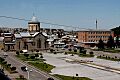
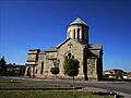
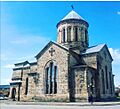
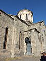
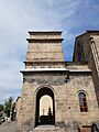
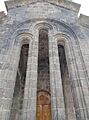
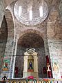
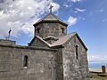
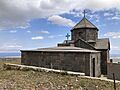
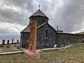
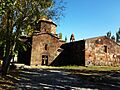
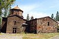
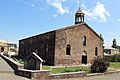
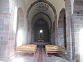
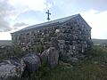
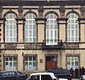
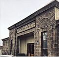
People and Faith in Gavar
.jpg)
.png)
Most people in Gavar are Christians. They belong to the Armenian Apostolic Church. The town has many old chapels and churches.
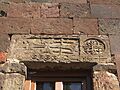
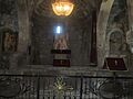
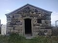
Important Churches in Gavar

.jpg)
- The Surp Karapet Church was built in 1848 and is still well-preserved.
- The Cathedral of the Holy Mother of God is the main church for the Diocese of Gegharkunik. It was built in 1905 with help from Bishop Khoren Muradbegian and local people.
- The Hatsarat Monastery has two churches: the Holy Mother of God (7th century) and Saint Gregory the Illuminator (19th century).
- The Hayravank Monastery from the 9th century is about 7 kilometers (4.3 miles) north of Gavar, by Lake Sevan.
- The Surp Khach (Holy Cross) chapel was built in the 17th century and fixed up in 1969.
- The Surp Karapet Church, built by Barsegh Artsruni in 1848, was fully renovated in 2012.
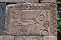
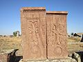
Noratus Cemetery
- The Noratus cemetery is an ancient site located just 4 kilometers (2.5 miles) east of Gavar. It has many impressive medieval khachkars (cross-stones), which are carved stone memorials.
| Historical population | ||
|---|---|---|
| Year | Pop. | ±% p.a. |
| 1831 | 1,346 | — |
| 1897 | 8,486 | +2.83% |
| 1916 | 14,748 | +2.95% |
| 1926 | 8,447 | −5.42% |
| 1939 | 8,277 | −0.16% |
| 1959 | 8,751 | +0.28% |
| 1974 | 21,382 | +6.14% |
| 1989 | 31,234 | +2.56% |
| 2001 | 26,621 | −1.32% |
Culture and Traditions in Gavar

Gavar has a history museum, a cultural palace, a drama theater, and public libraries. There is also a monument dedicated to those who died in World War II.
Arts and Education Centers
- The town has an educational teaching center (opened 1923).
- There's a music school (1945), a palace of culture (1970), and an art school (1982).
- A public library opened in 2002.
- A special school for the duduk (an Armenian musical instrument) named after Gevorg Dabaghyan opened in 2010.
- The town also has a youth creativity center.
Kyavar Online Portal
- Gavar has an online portal called Kyavar. Many people from Gavar who live abroad use it to stay connected. The name comes from how locals often say "Kyavar" instead of "Gavar."
Delicious Gavar Cuisine
The food in Gavar is similar to other Middle Eastern cuisines. It uses many spices, vegetables, fish, and fruits.
- Kyavari Kyufta: This is the town's most popular dish. It's made from minced meat mixed with onions. The meat is rolled into balls and boiled. It's served in slices with butter.
- Traditional Breads: People in Gavar love to eat bread with almost every meal. The two main types are lavash and matnakash.
- Kyavar Baklava: This is a sweet pastry with many thin layers of phyllo dough. It's filled with nuts and sugar, then soaked in hot honey.
Getting Around: Transportation in Gavar
Gavar is located on the M-10 Motorway, which connects it to northeastern Armenia. The H-39 Road links Gavar to nearby towns and villages. Gavar also has an airstrip, which has been there since the Soviet era. It is located north of the town.
Gavar's Economy and Businesses

In 1950, Gavar became an important industrial center in the Armenian SSR. It had a large electrical cable factory called Kamokabel and a machine manufacturing plant.
Modern Economy
- After Armenia became independent in 1991, many of the old Soviet-era factories closed down.
- However, the local economy is slowly getting better. Many business people who are from Gavar are returning from Russia to invest in the town.
- Today, Gavar is home to:
- The "Gavar Furniture Factory" (since 1948).
- The "Sevan Mineral Water Plant" (founded 1953, reopened 2015).
- "Aquatic LLC" (for processed crayfish, founded 2002).
- The "Kirakosyan" furniture factory (founded 2006).
- The "Shushan Production Cooperative" (for soft drinks).
Local Services
Gavar has a medical center and a central hotel called Khaldi. There is also a local TV station called Kyavar TV and several branches of Armenian banks.
Learning and Education in Gavar

Education is very important in Gavar. By 1960, almost everyone in the town could read and write.
Schools and University
- Today, Gavar has nine public schools and six nursery schools.
- There are four specialized technical colleges and one sports school.
- The town also has two music and art schools.
- The Gavar State University opened in 1993 after Armenia became independent. It is a major learning center for the entire Gegharkunik province.
- The university has five departments, offering degrees in subjects like languages, science, humanities, economics, and education. More than 2,400 students attend the university.
- The Gavar Special School is the only school in the region for children with special educational needs. It is working to improve and become a leading school in Armenia.
Sports in Gavar
Football (soccer) and chess are very popular in Gavar.
- The sports school in Gavar opened in 1971. It offers training in many team and individual sports. These include martial arts, basketball, futsal, boxing, and weightlifting.
- Hovhannes Goharyan, a football player from Gavar, played for the Armenia national football team in 2009-2010.
- In 2011, famous Armenian football player Henrikh Mkhitaryan visited Gavar with the president of the FFA for charity.
Gavar's International Connections
Twin Towns
Gavar is a twin town with:
 Novorossiysk, Russia, since 2009.
Famous People from Gavar
Here are some notable people who were born or grew up in Gavar:
- Ivan Gevorkian (1907-1989), a Soviet-Armenian surgeon and scientist.
- Samvel Kocharyants (1909-1993), a Soviet Armenian engineer who helped develop the first Soviet nuclear warheads.
- Frunze Dovlatyan (1927–1997), a film director, actor, and screenwriter.
- Hranush Hakobyan (1954-), a politician and former minister.
- Hovhannes Goharyan, a former professional football player.
Images for kids
-
A square in Gavar.
-
The Holy Mother of God Church in Gavar.
-
The Cathedral of Gavar.
-
Another view of the Holy Mother of God Church.
-
The Holy Mother of God Church, Gavar.
-
The Holy Mother of God Church, Gavar.
-
The Holy Mother of God Church, Gavar.
-
Surp Khach Church in Gavar.
-
Surp Khach Church in Gavar.
-
Surp Khach Church in Gavar.
-
Arnegh Monastery.
-
Arnegh Monastery complex.
-
Arnegh Monastery.
-
Arnegh Monastery.
-
Arnegh Monastery complex.
-
Arnegh Monastery.
-
Surp Karapet Church in Gavar.
-
Saint Karapet Church in Gavar.
-
Artsvatrich chapel.
-
Artsvatrich chapel.
-
Artsvatrich chapel.
-
Art school in Gavar.
-
Former cinema in Gavar.
-
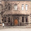
Old building in Gavar.
-
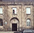
Government building in Gavar.
-
Russian colonial building.
-
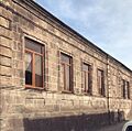
Stalinist building in Gavar.
-
Saint Stepanos chapel in Gavar.
-
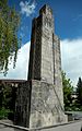
Monument to WWII victims in Gavar.

.jpg)


.jpg)
.jpg)
.jpg)
_2.jpg)
_4.jpg)
_5.jpg)
.jpg)

.jpg)
.jpg)

.jpg)

.jpg)
.jpg)
.jpg)
.jpg)


.jpg)

See also
 In Spanish: Gavar para niños
