Germantown, Kentucky facts for kids
Quick facts for kids
Germantown, Kentucky
|
|
|---|---|

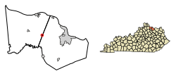
Location in Bracken County, Kentucky.
|
|
| Country | United States |
| State | Kentucky |
| Counties | Bracken, Mason |
| Named for | German immigrants |
| Area | |
| • Total | 0.12 sq mi (0.32 km2) |
| • Land | 0.12 sq mi (0.32 km2) |
| • Water | 0.00 sq mi (0.00 km2) |
| Elevation | 948 ft (289 m) |
| Population
(2020)
|
|
| • Total | 146 |
| • Density | 1,196.72/sq mi (460.41/km2) |
| Time zone | UTC-5 (Eastern (EST)) |
| • Summer (DST) | UTC-4 (EDT) |
| ZIP code |
41044
|
| Area code(s) | 606 |
| FIPS code | 21-30718 |
| GNIS feature ID | 2403692 |
Germantown is a small city in Kentucky, located in both Bracken and Mason counties. It is known as a "home rule-class city," which means it has the power to manage many of its own local affairs. In 2020, about 146 people lived there.
Part of Germantown in Bracken County is near the larger Cincinnati/Northern Kentucky metropolitan area. This means it's close to a big city and its surrounding towns. The part in Mason County is near the Maysville micropolitan area, which is a smaller city and its nearby towns.
Contents
History of Germantown
Germantown was first planned out in 1794. It was named after the German immigrants who settled in the area. Just one year later, in 1795, the city was officially recognized by the Virginia state legislature.
A post office opened in Germantown in 1817. It has been serving the community ever since.
Geography of Germantown
Germantown is mostly in eastern Bracken County, but a small part extends into western Mason County. Kentucky Route 10 is a main road that goes right through the middle of town. This road connects Germantown to other places.
If you go east on Kentucky Route 10 (using Kentucky Route 9), you can reach Maysville in about 13 miles. Maysville is located on the Ohio River. If you go west for about 6 miles, you'll get to Brooksville, which is the main town in Bracken County.
The city covers a total area of about 0.12 square miles, and all of it is land. Germantown sits on a raised area, like a small hill. Water from this area flows into several creeks. These include Bracken Creek, Pommel Creek, Two Lick Creek, and Camp Creek.
Bracken Creek flows directly into the Ohio River. The other three creeks eventually join the North Fork of the Licking River. The Licking River then flows northwest to meet the Ohio River in cities like Covington and Newport.
Population Changes in Germantown
| Historical population | |||
|---|---|---|---|
| Census | Pop. | %± | |
| 1800 | 81 | — | |
| 1810 | 36 | −55.6% | |
| 1830 | 118 | — | |
| 1850 | 125 | — | |
| 1860 | 170 | 36.0% | |
| 1870 | 191 | 12.4% | |
| 1890 | 229 | — | |
| 1900 | 407 | 77.7% | |
| 1910 | 287 | −29.5% | |
| 1920 | 237 | −17.4% | |
| 1930 | 283 | 19.4% | |
| 1940 | 304 | 7.4% | |
| 1950 | 260 | −14.5% | |
| 1960 | 251 | −3.5% | |
| 1970 | 332 | 32.3% | |
| 1980 | 347 | 4.5% | |
| 1990 | 213 | −38.6% | |
| 2000 | 190 | −10.8% | |
| 2010 | 154 | −18.9% | |
| 2020 | 146 | −5.2% | |
| U.S. Decennial Census | |||
According to the census from 2000, there were 190 people living in Germantown. These people lived in 81 different homes, and 55 of those were families. The population density was about 703 people per square mile.
Most of the people in Germantown in 2000 were White, making up about 98.42% of the population. About 1.58% were African American.
In terms of age, the population was spread out. About 22.6% of the people were under 18 years old. About 19.5% were 65 years old or older. The average age of people in the city was 39 years.
Famous People from Germantown
- Carl Bouldin, a professional baseball player.
- Elle Smith, a journalist and Miss USA 2021.
See also
 In Spanish: Germantown (Kentucky) para niños
 | Georgia Louise Harris Brown |
 | Julian Abele |
 | Norma Merrick Sklarek |
 | William Sidney Pittman |

