Gilmer County, Georgia facts for kids
Quick facts for kids
Gilmer County
|
||
|---|---|---|

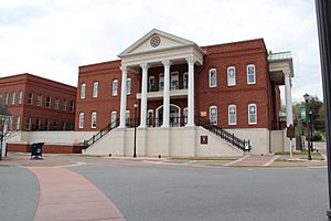
Gilmer County courthouse in Ellijay
|
||
|
||

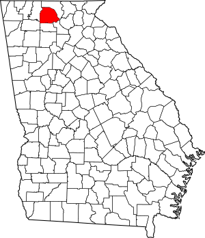
Location within the U.S. state of Georgia
|
||
 Georgia's location within the U.S. |
||
| Country | ||
| State | ||
| Founded | 1832 | |
| Named for | George Rockingham Gilmer | |
| Seat | Ellijay | |
| Largest city | Ellijay | |
| Area | ||
| • Total | 431 sq mi (1,120 km2) | |
| • Land | 427 sq mi (1,110 km2) | |
| • Water | 4.7 sq mi (12 km2) 1.1%% | |
| Population
(2020)
|
||
| • Total | 31,353 | |
| • Density | 73/sq mi (28/km2) | |
| Time zone | UTC−5 (Eastern) | |
| • Summer (DST) | UTC−4 (EDT) | |
| Congressional district | 9th | |
Gilmer County is a county in the U.S. state of Georgia. It is located in the northwest part of the state. In 2020, about 31,353 people lived there.
The main town, called the county seat, is Ellijay. This town was named after an old Cherokee village. Gilmer County was created on December 3, 1832. It is named after George Rockingham Gilmer, who was the governor of Georgia two times.
Gilmer County is famous for its yearly Apple Festival. This fun event happens in the middle of October. Most of the land in the county is used for farms and forests. Raising chickens and processing them is a big part of the local farming economy.
Contents
History of Gilmer County
Long ago, indigenous peoples lived in this area. It was part of the homeland of the Cherokee people. They had a village called Elatseyi. This name might mean "new ground" or "green place."
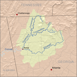
The village was located where the Ellijay and Cartecay Rivers meet. These two rivers then form the Coosawattee River. Later, the European-American town of Ellijay grew in this same spot.
In 1832, Gilmer County was officially formed. This happened as Georgia began to expand into Cherokee lands. Ellijay was chosen as the county seat in 1834. On January 12, 1854, parts of Gilmer County were used to create a new county called Fannin County.
Gilmer County is still mostly a rural area. Farming and forests are important for its economy. The county also has a growing number of tourists. Many visitors enjoy whitewater kayaking and canoeing on the local rivers.
Gilmer County's Economy
Farming is still a key part of Gilmer County's economy. By 2002, about 24,700 acres of land were used for agriculture. Most farms are medium-sized, between 10 and 179 acres.
Raising and processing chickens is the biggest part of the farming economy. Agriculture and related businesses bring in a lot of money for the county. Manufacturing, which means making things in factories, also adds a good amount to the economy.
Geography and Rivers
Gilmer County covers about 431 square miles. A small part of this area, about 4.7 square miles, is covered by water. The county is located in the beautiful Blue Ridge Mountains.
Most of Gilmer County is in the Coosawattee River area. This river is part of a larger river system called the ACT River Basin. Some smaller parts of the county are also near other rivers like the Conasauga River and the Ocoee River.
Neighboring Counties
Gilmer County shares its borders with several other counties:
- Fannin County (to the north)
- Dawson County (to the southeast)
- Pickens County (to the south)
- Gordon County (to the southwest)
- Murray County (to the west)
Protected Natural Areas
A part of the Chattahoochee National Forest is located within Gilmer County. This forest is a protected area.
Transportation Routes
Main Highways
Other Important Roads
- Old S.R. 5
- Yukon Road
- Burnt Mountain Road
- Boardtown Road
- Big Creek Road
- Doublehead Gap Road
- Whitestone Road
- Conasauga Road
Population and People
| Historical population | |||
|---|---|---|---|
| Census | Pop. | %± | |
| 1840 | 2,536 | — | |
| 1850 | 8,440 | 232.8% | |
| 1860 | 6,724 | −20.3% | |
| 1870 | 6,644 | −1.2% | |
| 1880 | 8,386 | 26.2% | |
| 1890 | 9,074 | 8.2% | |
| 1900 | 10,198 | 12.4% | |
| 1910 | 9,237 | −9.4% | |
| 1920 | 8,406 | −9.0% | |
| 1930 | 7,344 | −12.6% | |
| 1940 | 9,001 | 22.6% | |
| 1950 | 9,963 | 10.7% | |
| 1960 | 8,922 | −10.4% | |
| 1970 | 8,956 | 0.4% | |
| 1980 | 11,110 | 24.1% | |
| 1990 | 13,368 | 20.3% | |
| 2000 | 23,456 | 75.5% | |
| 2010 | 28,292 | 20.6% | |
| 2020 | 31,353 | 10.8% | |
| 2023 (est.) | 32,860 | 16.1% | |
| U.S. Decennial Census 1790-1880 1890-1910 1920-1930 1930-1940 1940-1950 1960-1980 1980-2000 2010 |
|||
In 2020, the census showed that 31,353 people lived in Gilmer County. There were 12,021 households and 8,028 families.
Population Details (2020)
| Race | Number | Percent |
|---|---|---|
| White | 26,365 | 84.09% |
| Black or African American | 127 | 0.41% |
| Native American | 62 | 0.2% |
| Asian | 131 | 0.42% |
| Other/mixed | 1,069 | 3.41% |
| Hispanic or Latino | 3,599 | 11.48% |
Population Details (2010)
In 2010, about 28,292 people lived in the county. Most people were White (92.3%). About 9.5% of the population was of Hispanic or Latino origin.
The average age of people in Gilmer County was 43.4 years. The average income for a household was $36,741. About 18.1% of all people in the county lived below the poverty line. This included 24.1% of those under 18 years old.
Attractions and Nature
Gilmer County is home to a very large yellow poplar tree. People often call it "the big poplar." This amazing tree is 100 feet tall. Its base is about 20 feet around. You can visit this tree by walking along the Bear Creek Trail. This trail is located in the Chattahoochee National Forest.
Communities in Gilmer County
Cities
Census-designated place
Unincorporated communities
These are smaller communities that are not officially cities:
- Ai
- Tails Creek
- Whitepath
- Yukon
Images for kids
See also
 In Spanish: Condado de Gilmer (Georgia) para niños
 | Selma Burke |
 | Pauline Powell Burns |
 | Frederick J. Brown |
 | Robert Blackburn |


