
Gobernador Piñero, San Juan, Puerto Rico facts for kids
Quick facts for kids
Gobernador Piñero
|
|
|---|---|

San Patricio Forest in Gobernador Piñero
|
|

Location of Gobernador Piñero shown in yellow.
|
|
| Commonwealth | |
| Municipality | |
| Area | |
| • Total | 4.83 sq mi (12.5 km2) |
| • Land | 4.56 sq mi (11.8 km2) |
| • Water | 0.27 sq mi (0.7 km2) |
| Elevation | 95 ft (29 m) |
| Population
(2010)
|
|
| • Total | 44,006 |
| • Density | 9,650.4/sq mi (3,726.0/km2) |
| 2010 census | |
| Time zone | UTC−4 (AST) |
Gobernador Piñero is a special area, or "barrio," in the city of San Juan, Puerto Rico. It is one of the 18 barrios that make up the municipality of San Juan. In 2010, about 44,000 people lived there. This makes it the second most populated barrio in San Juan. It is also the fourth largest in terms of land area.
This area is named after Jesús T. Piñero. He was an important person in Puerto Rico's history. In 1946, he became the first and only Puerto Rican to be a governor of the territory under American rule.
Contents
About Gobernador Piñero
How Many People Live Here?
Gobernador Piñero is a busy place! It is San Juan’s second most populated barrio. Only Santurce has more people. About 10,770 people live in each square mile of Gobernador Piñero.
| Historical population | |||
|---|---|---|---|
| Census | Pop. | %± | |
| 1950 | 23,079 | — | |
| 1970 | 59,896 | — | |
| 1980 | 51,091 | −14.7% | |
| 1990 | 49,427 | −3.3% | |
| 2000 | 47,779 | −3.3% | |
| 2010 | 44,006 | −7.9% | |
| U.S. Decennial Census 1900 (N/A) 1910-1930 1930-1950 1980-2000 2010 |
|||
Where is Gobernador Piñero?
Gobernador Piñero is located in a key part of San Juan. To the north, it touches the San Juan Bay and Port. It also borders the Hato Rey Norte barrio.
To the east, you will find the barrios of Hato Rey Sur and El Cinco. To the south, it borders Monacillo Urbano. To the west, it is next to the municipality of Guaynabo.
Areas Inside Gobernador Piñero
This barrio includes several well-known areas. These are Puerto Nuevo (which includes Puerto Nuevo Norte), Villa Borinquen, and Caparra Terrace. It also has the Bosque Urbano de San Patricio and Centro Médico.
What Can You See and Do?
Gobernador Piñero has many interesting places to visit.
- Luis Muñoz Marín Park: This is one of the main city parks in San Juan. It is a great place to relax and play.
- Port of San Juan: A part of San Juan's important port is located here. This is where many ships come and go.
- San Juan Medical Center: Also known as Centro Médico de Rio Piedras, this is a major hospital and medical facility.
- San Patricio State Forest: This forest is also called the San Patricio Urban Forest. It is one of the 20 state forests in Puerto Rico. It is a green space in the city.
- University of Puerto Rico, Medical Sciences Campus: This is a campus of the University of Puerto Rico. It focuses on medical studies.
Getting Around
It is easy to travel around Gobernador Piñero. The area is served by several metro stations. These stations are part of the Tren Urbano system.
The metro stations include:
- Martínez Nadal (which is on the border with Guaynabo)
- Las Lomas
- San Francisco
- Centro Médico
Gallery
-
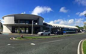
Martínez Nadal metro system station.
-
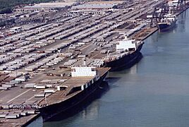
The Port of San Juan is partially located in this barrio.
-
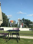
Luis Muñoz Marín Park
.jpg)

.jpg)
See also
 In Spanish: Gobernador Piñero para niños
