Golf, Florida facts for kids
Quick facts for kids
Golf, Florida
|
||
|---|---|---|
| Village of Golf | ||
|
||

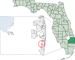
Location of Village of Golf, Florida
|
||
| Country | ||
| State | ||
| County | ||
| Founded | 1956 | |
| Incorporated | May 30, 1957 | |
| Named for | Golf, Illinois | |
| Government | ||
| • Type | Council-Manager | |
| Area | ||
| • Total | 0.83 sq mi (2.15 km2) | |
| • Land | 0.82 sq mi (2.12 km2) | |
| • Water | 0.01 sq mi (0.03 km2) | |
| Elevation | 13 ft (4 m) | |
| Population
(2020)
|
||
| • Total | 255 | |
| • Density | 310.98/sq mi (120.02/km2) | |
| Time zone | UTC-5 (Eastern (EST)) | |
| • Summer (DST) | UTC-4 (EDT) | |
| ZIP code |
33436
|
|
| Area code(s) | 561, 728 | |
| FIPS code | 12-26550 | |
| GNIS feature ID | 0283160 | |
The Village of Golf is a small community located in Palm Beach County, Florida, in the United States. It is also part of the larger Miami metropolitan area in South Florida. In 2020, the U.S. Census Bureau counted 255 people living there.
Contents
History of Golf, Florida
Golf was started in 1956. It was designed as a special community built around a golf course. Some of the first people who settled here came from a place called Golf, Illinois. They liked the name so much that they chose it for their new village. The Village of Golf officially became a town in 1957.
Geography of Golf, Florida
The Village of Golf is located at specific coordinates: 26.504264 degrees North and 80.104759 degrees West. This helps pinpoint its exact spot on a map.
According to the United States Census Bureau, the village covers a total area of about 0.8 square miles (2.1 square kilometers). Almost all of this area is land, with only a tiny part, about 1.19%, being water.
The village is completely surrounded by land. It is bordered by parts of the city of Boynton Beach to its east and south. To its west and north, it touches other areas that are not officially part of a city. These areas include golf courses, parks, and wetlands. Even though these areas are outside the village, they often share Boynton Beach mailing addresses.
Climate in Golf, Florida
The Village of Golf has a tropical climate. This means it is warm all year round, much like the weather you would find in many parts of the Caribbean. It is one of the few places in the main 48 states with this type of climate.
More specifically, it usually has a tropical savanna climate. This climate often has a dry season and a wet season. It is also very close to a tropical monsoon climate, which means it can get a lot of rain during certain times of the year.
Population and People of Golf, Florida
| Historical population | |||
|---|---|---|---|
| Census | Pop. | %± | |
| 1960 | 35 | — | |
| 1970 | 50 | 42.9% | |
| 1980 | 110 | 120.0% | |
| 1990 | 234 | 112.7% | |
| 2000 | 230 | −1.7% | |
| 2010 | 252 | 9.6% | |
| 2020 | 255 | 1.2% | |
| U.S. Decennial Census | |||
The population of Golf, Florida, has grown over the years. In 1960, only 35 people lived there. By 2020, the population had reached 255 people.
Who Lives in Golf?
In 2020, the 2020 United States census counted 255 people living in the village. There were 124 households and 101 families.
In 2010, the 2010 United States census showed 252 people. There were 141 households and 111 families living in Golf.
See also
 In Spanish: Golf (Florida) para niños


