Grant County, Kansas facts for kids
Quick facts for kids
Grant County
|
|
|---|---|
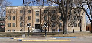
Grant County Courthouse in Ulysses (2015)
|
|
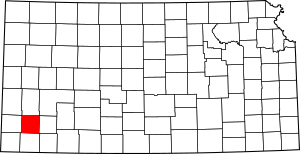
Location within the U.S. state of Kansas
|
|
 Kansas's location within the U.S. |
|
| Country | |
| State | |
| Founded | March 20, 1873 |
| Named for | Ulysses S. Grant |
| Seat | Ulysses |
| Largest city | Ulysses |
| Area | |
| • Total | 575 sq mi (1,490 km2) |
| • Land | 575 sq mi (1,490 km2) |
| • Water | 0.3 sq mi (0.8 km2) 0.06%% |
| Population
(2020)
|
|
| • Total | 7,352 |
| • Estimate
(2023)
|
7,147 |
| • Density | 12.8/sq mi (4.9/km2) |
| Time zone | UTC−6 (Central) |
| • Summer (DST) | UTC−5 (CDT) |
| Congressional district | 1st |
Grant County is a county in the state of Kansas. It is named after Ulysses S. Grant, who was the 18th President of the United States.
The main city and county seat (the place where the county government is) is Ulysses. This city is also named after President Grant. In 2020, about 7,352 people lived in Grant County.
Contents
History of Grant County
Grant County has an interesting history, with its borders changing several times.
How Grant County Started
In 1873, a large part of western Kansas was divided into 25 new counties. Grant County was one of these. It was named after Ulysses S. Grant, who was the president at that time. The first survey to mark the county's boundaries happened in the summer of 1874.
Changes to the County Borders
In 1883, some counties in Kansas, including Grant County, disappeared. Grant County was split up. Its western part became part of Hamilton County. The eastern part joined the newly created Finney County.
But Grant County didn't stay gone for long! On June 9, 1888, it was officially re-established. It got its original borders back. The first leaders of the "new" Grant County started their jobs on June 18, 1888.
Choosing the County Seat
In October 1888, the people of Grant County voted to choose their county seat. The town of Ulysses won by a lot of votes.
| Town Name | Vote count |
|---|---|
| Ulysses | 578 |
| Appomattox | 268 |
| Shockeyville | 41 |
| Golswn | 31 |
| Spurgeon | 2 |
The Dust Bowl Years
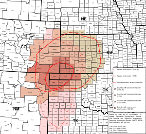
In the 1930s, Grant County was hit hard by the Dust Bowl. This was a time when severe dust storms damaged farms across the Great Plains. This natural disaster made the Great Depression even worse for the people living there.
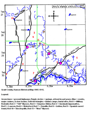
Early Settlements in Grant County
Before Ulysses became the main city, there were other small communities. Some of these early settlements included:
- "Old" Ulysses (which later moved to "New" Ulysses in 1909)
- Surprise-Tilden
- Cincinnati-Appomattox
- Shockey (also called Shockeyville)
- Golden
- Zionville
- Lawson
- Waterford
- Gognac
- Spurgeon
Geography of Grant County
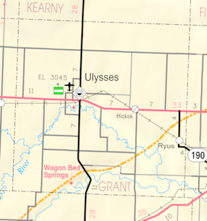
Grant County is mostly land. It covers about 575 square miles (1,490 square kilometers). Only a tiny bit, about 0.3 square miles (0.78 square kilometers), is water.
Main Roads
Two important highways run through Grant County:
 U.S. Highway 160
 Kansas Highway 25
Neighboring Counties
Grant County shares its borders with several other counties:
- To the north: Kearny County
- To the northeast: Finney County
- To the east: Haskell County
- To the south: Stevens County
- To the west: Stanton County
- To the northwest: Hamilton County
Population and People
The population of Grant County has changed over the years. Here's how many people lived there at different times:
| Historical population | |||
|---|---|---|---|
| Census | Pop. | %± | |
| 1890 | 1,308 | — | |
| 1900 | 422 | −67.7% | |
| 1910 | 1,087 | 157.6% | |
| 1920 | 1,087 | 0.0% | |
| 1930 | 3,092 | 184.5% | |
| 1940 | 1,946 | −37.1% | |
| 1950 | 4,638 | 138.3% | |
| 1960 | 5,269 | 13.6% | |
| 1970 | 5,961 | 13.1% | |
| 1980 | 6,977 | 17.0% | |
| 1990 | 7,159 | 2.6% | |
| 2000 | 7,909 | 10.5% | |
| 2010 | 7,829 | −1.0% | |
| 2020 | 7,352 | −6.1% | |
| 2023 (est.) | 7,147 | −8.7% | |
| U.S. Decennial Census | |||
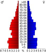
In 2000, there were about 7,909 people living in Grant County. Many families lived there, and about 43.6% of households had children under 18. The average household had about 2.86 people.
The median age in the county in 2000 was 31 years old. This means half the people were younger than 31, and half were older. About 32.8% of the population was under 18.
Education
Grant County has one main school district:
- Ulysses USD 214
Communities in Grant County
Grant County has one main city and a few smaller communities. It is also divided into three areas called townships.
City
- Ulysses (This is the county seat and the only incorporated city.)
Unincorporated Communities
These are smaller places that are not officially cities:
Townships
Grant County is divided into three townships. The population numbers for these townships include the people living in any cities or communities within them.
| Township | Population center |
Population | Land area km2 (sq mi) |
Water area km2 (sq mi) |
|---|---|---|---|---|
| Lincoln | Ulysses | 7,058 | 372 (144) | 0 (0) |
| Sherman | 498 | 559 (216) | 0 (0) | |
| Sullivan | 353 | 558 (215) | 0 (0) |
See also
 In Spanish: Condado de Grant (Kansas) para niños


