
Greater Armenia (political concept) facts for kids
Greater Armenia or United Armenia is a political idea where many Armenians want to unite all lands they believe are "historically or ethnically Armenian" with the modern Republic of Armenia. This idea is about bringing together places where Armenians have lived for a long time, even if they are now part of other countries.
Contents
What is United Armenia?
The idea of United Armenia is a dream for many Armenians. It means bringing together different areas that are seen as part of a larger Armenian homeland. These areas include the current Republic of Armenia, a region called Nagorno-Karabakh (also known as Artsakh), and other historical Armenian lands. Some of these historical lands are now in Turkey (often called Western Armenia), Azerbaijan (like Nakhchivan), and Georgia (like Javakheti).
Why do Armenians want this?
Armenians have a very long history in the region. For thousands of years, they have lived in the Armenian Highland. They built kingdoms, churches, and developed a unique culture and language there. Over time, parts of these lands came under the rule of different empires and countries.
Many Armenians feel a strong connection to these historical lands. They believe that these areas should be part of a single Armenian state. This feeling is often linked to their history, including difficult times like the Armenian Genocide, which led to many Armenians being forced to leave their homes in what is now Turkey.
Historical Claims and Maps
The idea of United Armenia has been around for a long time. After World War I, when the Ottoman Empire fell, there was a chance for Armenians to create a larger state.
The Treaty of Sèvres
In 1920, a treaty called the Treaty of Sèvres was signed. This treaty planned to create a much larger Armenia. It included parts of the former Ottoman Empire that were historically Armenian. The borders for this new Armenia were even drawn by Woodrow Wilson, who was the President of the United States at the time.
However, this plan never fully happened. The political situation changed, and the Turkish War of Independence led to new borders. The Republic of Armenia that exists today is much smaller than what was envisioned in the Treaty of Sèvres.
Modern Ideas of Unity
Today, different groups and political parties in Armenia and among Armenians around the world have their own ideas about what United Armenia should look like.
- Republic of Armenia and Artsakh: The most common idea includes the current Republic of Armenia and the region of Artsakh (Nagorno-Karabakh). Artsakh has a very large Armenian population and has been a central part of this idea.
- Western Armenia: This refers to the historical Armenian lands in eastern Turkey, including Mount Ararat. Mount Ararat is a very important symbol for Armenians, even though it is now in Turkey.
- Nakhchivan: This is an area in Azerbaijan that once had a significant Armenian population.
- Javakheti: This is a region in southern Georgia with a large Armenian community.
These ideas are often shown on maps that outline the desired territories. These maps are powerful symbols for many Armenians, representing their historical connection to the land and their hopes for the future.
Related pages
Images for kids
-
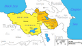
The modern concept of United Armenia as claimed by the Armenian Revolutionary Federation. Orange: areas overwhelmingly populated by Armenians (Republic of Armenia: 98%; Nagorno-Karabakh: 99%; Javakheti: 95%). Yellow: Historically Armenian areas with presently no or insignificant Armenian population (Western Armenia and Nakhchivan). Note: Artsakh (Nagorno-Karabakh) is shown in pre-2020 de facto borders.
-
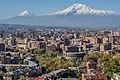
Mount Ararat, today located in Turkey, as seen from Armenia's capital Yerevan. The mountain is a symbol of Western Armenia for many Armenians.
-
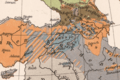
An ethnographic map of the Armenian Highland (and the wider Asia Minor and the Caucasus), made by Richard Andree in 1905. Armenians are labeled in blue.
-
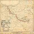
A map presented by the Armenian National Delegation (representing Ottoman Armenians) to the 1919 Paris Peace Conference.
-
Armenia's Prime Minister Alexander Khatisian declared the formal unification of the Armenian lands in 1919.
-
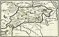
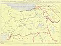
The Armenian-Turkish border by the Treaty of Sèvres
-
Armenian and Georgian claims to Turkish Territory, British Foreign Office, May 1946
-
The logo of ASALA, depicted here on a memorial at the Yerablur cemetery, was the outline map of United Armenia.
-
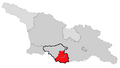
Javakhk (Javakheti) shown in red on the map of Georgia with Samtskhe-Javakheti provincial borders outlined. Abkhazia and South Ossetia, both areas are not under the control of the central government of Georgia, shown in light grey.
-
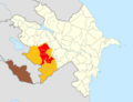
Nakhichevan shown in brown. The area de facto held by the Nagorno-Karabakh Republic until 2020 Nagorno-Karabakh war shown in yellow.
-

Lebanese Armenians holding a poster during Turkish Prime Minister Erdoğan's visit to Beirut in November 2010. The text reads "[Mount] Ararat is and remains Armenian".
-
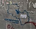
A graffiti in Yerevan of the map outline of Armenia and Nagorno-Karabakh. The text reads "Liberated, not occupied."
-
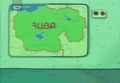
The map of Armenia as seen in 2005 animated film Road home.


See also
 In Spanish: Gran Armenia para niños
