Greenwich (CDP), Connecticut facts for kids
Quick facts for kids
Greenwich, Connecticut
|
|
|---|---|

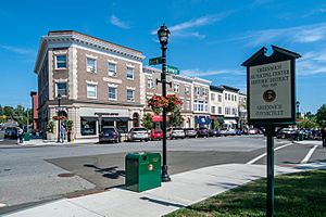
Greenwich Municipal Center Historic District
|
|

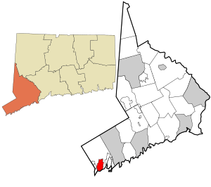
Location in Fairfield County and the state of Connecticut.
|
|
| State | Connecticut |
| County | Fairfield |
| Town | Greenwich |
| Area | |
| • Total | 4.43 sq mi (11.48 km2) |
| • Land | 4.11 sq mi (10.65 km2) |
| • Water | 0.32 sq mi (0.83 km2) |
| Elevation | 118 ft (36 m) |
| Population
(2010)
|
|
| • Total | 12,942 |
| • Density | 3,148/sq mi (1,215.3/km2) |
| ZIP Codes |
06830, 06831
|
| FIPS code | 09-33690 |
| GNIS feature ID | 2631566 |
Greenwich is a special area in Fairfield County, Connecticut, United States. It's called a census-designated place (CDP). Think of it as a specific part of the larger town of Greenwich. This CDP includes the old town center and the homes and shops around it. In 2010, about 12,942 people lived in the Greenwich CDP. The entire town of Greenwich had a population of 61,171 people.
Contents
Exploring Greenwich's Location
This part of Greenwich is in the south-central area of the town. To the south, it touches the Long Island Sound. This is a large body of water that connects to the Atlantic Ocean. The CDP includes Greenwich Harbor, which is a bay. It also has important historic areas like the Greenwich Avenue Historic District.
Nearby Areas and Roads
Greenwich CDP is next to other neighborhoods. To the west, you'll find Pemberwick and Byram. Just a short distance to the east is Cos Cob.
A main road, U.S. Route 1 (also called Putnam Avenue), goes right through the middle of Greenwich. If you go northeast on this road, you'll reach Stamford in about 5 miles. Going southwest for about 2.5 miles will take you to Port Chester, New York.
Another big road, Interstate 95, runs south of U.S. Route 1. You can get onto I-95 from Exit 3 (Arch Street). There's also a train station, the Greenwich Metro-North station, right in the center of town, close to I-95.
Size of Greenwich CDP
The U.S. Census Bureau says that the Greenwich CDP covers about 11.5 square kilometers (or 4.4 square miles). Most of this area is land, about 10.6 square kilometers (4.1 square miles). The rest, about 0.8 square kilometers (0.3 square miles), is water.
People of Greenwich
In 2010, there were 12,942 people living in the Greenwich CDP. These people lived in 5,779 households. A household is a group of people living in one home. Out of these, 3,247 were families.
Who Lives Here?
- About 26.9% of households had kids under 18 living with them.
- Many households (41.9%) were married couples living together.
- About 11.6% were led by a woman without a husband.
- About 38.0% of all households were just one person living alone.
- About 15.6% of households had someone living alone who was 65 or older.
The average household had 2.22 people. The average family had 2.98 people.
Age Groups
The people in Greenwich CDP come from different age groups:
- 21.7% were under 18 years old.
- 5.2% were between 18 and 24.
- 26.3% were between 25 and 44.
- 29.1% were between 45 and 64.
- 17.8% were 65 years old or older.
The average age of people in Greenwich CDP was 42.9 years.
Learning in Greenwich
The schools in Greenwich CDP are part of the Greenwich Public Schools district. This district has a main high school called Greenwich High School. It's where many students in the area go for their high school education.
There was also a campus of the Japanese School of New York in Greenwich CDP.
See also
 In Spanish: Greenwich (condado de Fairfield) para niños
 | Sharif Bey |
 | Hale Woodruff |
 | Richmond Barthé |
 | Purvis Young |

