
Harrow Way facts for kids

The Harrow Way is an old road in the south of England. It is also called the "Old Way". This ancient path has been used for a very long time, possibly since the Stone Age. Archaeologists have found items along the path that date back to 600–450 BC.
The Old Way stretched from Seaton in Devon all the way to Dover in Kent. Later, the eastern part of the Harrow Way became known as the Pilgrims Way. This happened after Thomas Beckett became a saint and a special shrine was built for him in Canterbury, Kent. The Pilgrims Way was a route for people on a pilgrimage (a religious journey). It went from Winchester, Hampshire, through Farnham, Surrey, to Canterbury.
People think the name "Harrow Way" might come from different old words. It could mean "military road," "ancient way," or even "road to a shrine," possibly referring to Stonehenge. Some people call it the 'oldest road in Britain'. It might have been used for trading tin from Dartmoor.
Contents
What is the Harrow Way?
The Harrow Way is a very old trackway that crosses southern England. It was used by people for thousands of years to travel and trade. It shows us how people moved around and connected different parts of the country long ago.
The Eastern Harrow Way

The eastern part of the Harrow Way starts in Farnham, Surrey. This section later became famous as the Pilgrims' Way. It runs close to or along the North Downs Way National trail. You can follow the Harrow Way from places like Rochester and other ports on the Strait of Dover.
Another main path started in the valley of the Great Stour near Canterbury. It followed the North Downs hills, or their southern slopes, passing through Maidstone and Guildford before reaching Farnham. This route was often used because its soil drained well and was good for walking all year round.
The Pilgrims' Way
The Pilgrims' Way is a special part of the Harrow Way. It goes from Farnham to Winchester. This route helped Winchester grow into an important city. Winchester was already a religious center with the shrine of St Swithin. It was also a meeting point for travelers coming from the south coast.
Farnham was another important meeting spot for travelers coming from the south. The path going east from Farnham went through what is now Farnham Park. It continued along the chalk hills, crossed the Bagshot Road, and passed Badshot Lea, Surrey. An important ancient burial mound (called a tumulus) from the Stone Age was found here. The Harrow Way then continued to the top of the Hog's Back, where many other ancient burial mounds can be found.
The Western Harrow Way

The western part of the Old Way, also known as the Harrow Way, starts in Farnham, Surrey. It goes west through Basingstoke and Andover to Salisbury Plain and Stonehenge in Wiltshire. From there, it continues through Dorset and ends at Seaton on the Devon coast.
In Dorset, you can find parts of the Harrow Way in villages like Halstock and Corscombe. Here, it is known as Common Lane. Near Halstock, a short part of the old path was changed to make an entrance for a Roman villa. This Roman building was actually built on the site of an even older farm from the late Iron Age.
Images for kids
-
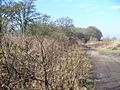
The Harrow Way - a surviving track northeast of Overton, Hampshire

