
Hell's Half Acre Lava Field facts for kids
Quick facts for kids Hell's Half Acre Lava Field |
|
|---|---|

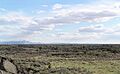
View of Hell's Half Acre Lava Field
|
|
| Highest point | |
| Elevation | 1,631 metres (5,351 ft) |
| Geography | |
| Location | Bonneville and Bingham counties, Idaho, U.S. |
| Geology | |
| Mountain type | Shield volcano, lava plain |
| Last eruption | 3250 BCE ± 150 years |
| Designated: | 1976 |
Hell's Half Acre Lava Field is a huge area of hardened basalt lava in Idaho, United States. It's like a giant, flat plain made of rock that came from a volcano. This special place is located about 25 miles (40 km) west of Idaho Falls, Idaho and 30 miles (48 km) north of Pocatello, Idaho.
In 1976, a part of Hell's Half Acre was named a National Natural Landmark. This means it's a very important natural area. Later, in 1986, another large section of about 68,760 acres (27,830 ha) was suggested to become a special wilderness study area.
Contents
Exploring Hell's Half Acre Lava Field
This amazing lava plain covers about 150 square miles (390 km2) of land in Idaho. Near the center of the lava field, you can find a large dip in the ground. This dip, about 875-yard (800 m) long, is where a lava lake used to be! Imagine a lake of molten rock.
There are also ten round pits and two big lava tubes near the center. Lava tubes are like underground tunnels formed when lava flows and cools on the outside, but keeps flowing inside. Scientists have also found a long crack, called an eruptive fissure, partly hidden by the lava. This crack might be as long as 11.8 miles (19.0 km)!
How to Visit the Lava Field
It's pretty easy to get to Hell's Half Acre. The main highway, Interstate 15, even crosses the corner of the lava field. The U.S. Bureau of Land Management has marked several trails for visitors.
There's a shorter trail, about 0.5-mile-long (0.80 km), marked with blue flags. It takes about 30 minutes to walk. If you're up for a bigger adventure, there's a longer trail, about 4.5-mile-long (7.2 km), marked with red flags. This one takes a whole day to hike and leads to the main volcanic vent.
You can also find shorter trails with signs that teach you about the area. One is 0.75 miles (1.21 km) long and starts from the north parking lot. Another is about 1 mile (1.6 km) long from the south parking lot. This longer trail has a gazebo and a great view point. There's even a 0.25-mile-long (0.40 km) paved loop that's easy for everyone to use. All the trails are closed during winter. Lots of people, over 100,000, visited these trails in 2007!
Plants and Animals of the Lava Field
Even though it's a lava field, Hell's Half Acre is full of life! Many different plants grow here. You might see bitterbrush, bluebunch wheatgrass, evening primrose, ferns, geraniums, and sagebrush. There are also interesting plants like foothills death camas, Indian paintbrush, needle-and-thread grass, penstemon, prickly pear cactus, Utah juniper, and wild onion.
Animals also call this place home. Keep an eye out for bobcats, coyotes, golden eagles, mule deer, elk, prairie falcons, pronghorn, red foxes, red-tailed hawks, and sage grouse.
History of Hell's Half Acre

Scientists believe Hell's Half Acre Lava Field was formed around 3250 BC. It was created by a long crack in the Earth called the Lava Ridge-Hell's Half Acre fissure vent. This crack formed when hot, melted rock, called magma, pushed its way up to the surface.
At one end of the lava field is a basaltic volcano that looks like a shield volcano. This type of volcano is wide and flat, like a warrior's shield. Along the crack, you can also see pit craters (holes formed when the ground collapses) and spatter cones (small, steep cones built from blobs of lava).
How the Lava Field Formed
Hell's Half Acre was created when a type of lava called pāhoehoe flowed out very quickly. Pāhoehoe lava is smooth and ropey when it cools. Geologists have found at least eight different flows of this lava. As the magma and gases drained away from under the lava field, the ground sank a bit. This left behind small hills of lava, which you can still see today. It looks like the lava lake filled up and drained many times, and lava often spilled over its edges.
The lava from the crack usually flowed downhill towards the southeast. It even flowed underneath or inside older lava flows, sometimes breaking out in new places.
Naming and Early Explorers
The name "Hell's Half Acre" was given by fur traders in the early 1800s. They used this phrase to describe any very rough or difficult land to travel through.
One of the first non-Native American explorers to write about Hell's Half Acre was Benjamin Bonneville. He was a French-born U.S. Army officer who explored the West in 1832. He saw the lava field in 1833. A famous writer named Washington Irving used Bonneville's notes to write a book. Irving described the area as having "numerous and dangerous chasms" that were very deep.
Logging and Recent Events
In the late 1800s and early 1900s, people used to cut down red cedar trees in the lava field. These trees can grow right on rocks! A village called Woodville was even founded nearby to harvest the wood. This practice slowed down when coal became a popular fuel, but cutting red cedar continued until 1942.
In 1999, a wildfire burned about 500 acres (200 ha) of the lava field. More recently, in 2006, a power company called Utah Power wanted to build an electrical substation near the eastern part of Hell's Half Acre.
Today, the Lava Trail System (which used to be called Hell's Half Acre) lets people explore this unique volcanic landscape on foot.
Images for kids
-
View of Hell's Half Acre Lava Field
-
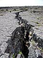
A rift, or crack, in the lava plain at Hell's Half Acre in Idaho.
