
Dardanelles facts for kids

The Dardanelles is a very important narrow waterway in northwestern Turkey. It connects the Aegean Sea to the Sea of Marmara. This strait acts like a natural border, separating the continent of Asia on its eastern side from Europe on its western side. Because of its location, it has always been a very significant passage for ships and countries in the region.
Long ago, in the times of Ancient Greece, this strait was known by another name: the Hellespont.
Contents
What is the Dardanelles?
The Dardanelles is a natural strait, which is a narrow passage of water connecting two larger bodies of water. It is about 61 kilometers (38 miles) long and only 1.2 to 6 kilometers (0.75 to 3.7 miles) wide. The average depth is around 55 meters (180 feet), but it can be as deep as 103 meters (338 feet) in some places.
Where is it located?
This important strait is entirely within Turkey. It forms a key part of the Turkish Straits, which also include the Bosphorus strait and the Sea of Marmara. These waterways are the only sea route between the Black Sea and the Mediterranean Sea.
Why is it important?
The Dardanelles is incredibly important for many reasons.
- Trade and Shipping: It is a vital shipping lane for countries around the Black Sea, like Russia and Ukraine. Their ships must pass through the Dardanelles to reach the Mediterranean Sea and the rest of the world's oceans.
- Military Strategy: Controlling this strait has been a goal for many empires and nations throughout history. It offers a strategic advantage for defense and trade.
- Geography: It marks a clear geographical boundary between two continents, Europe and Asia.
A Look Back in Time
The Dardanelles has a rich and dramatic history, playing a role in many famous events.
The Hellespont in Ancient Greece
In ancient times, the Dardanelles was known as the Hellespont. It is famous from Greek myths and history.
- Myth of Helle: The name "Hellespont" comes from the Greek myth of Helle, who supposedly drowned in its waters.
- Troy: The ancient city of Troy, famous from the story of the Trojan War, was located very close to the Asian side of the Dardanelles.
- Xerxes' Bridge: In 480 BC, the Persian King Xerxes I built a famous pontoon bridge across the Hellespont. This allowed his massive army to cross from Asia into Europe to invade Greece.
World War I and Gallipoli
One of the most well-known events involving the Dardanelles happened during World War I.
- The Dardanelles Campaign: In 1915, the Allied Powers (like Britain, France, Australia, and New Zealand) launched a major attack known as the Gallipoli Campaign. Their goal was to capture the Dardanelles. This would allow them to reach the Ottoman Empire's capital, Constantinople (modern-day Istanbul), and open a supply route to Russia.
- Fierce Fighting: The campaign involved very fierce fighting on the Gallipoli peninsula. It lasted for many months and resulted in heavy losses for both sides. The Allied forces were eventually forced to withdraw.
- Legacy: The Gallipoli Campaign is a very important part of the history of Australia and New Zealand. Anzac Day is celebrated every year to remember the bravery and sacrifice of their soldiers.
The Dardanelles Today
Today, the Dardanelles remains a crucial waterway.
- Shipping: Thousands of ships, including huge oil tankers and cargo vessels, pass through the strait every year.
- The Çanakkale 1915 Bridge: In 2022, the Çanakkale 1915 Bridge was opened across the Dardanelles. This amazing suspension bridge connects the European and Asian sides of Turkey. It is currently the longest suspension bridge in the world.
Images for kids
-
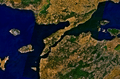
View of the Dardanelles taken from the Landsat 7 satellite in September 2006. The body of water on the left is the Aegean Sea, while the one on the upper right is the Sea of Marmara. The Dardanelles is the tapered waterway running diagonally between the two seas, from the northeast to the southwest. The long, narrow upper peninsula on the northern shores of the strait is Gallipoli (Turkish: Gelibolu), and constitutes the banks of the continent of Europe, while the lower peninsula is Troad (Turkish: Biga) and constitutes the banks of the continent of Asia. The city of Çanakkale is visible along the shores of the lower peninsula, centered at the only point where a sharp outcropping juts into the otherwise-linear Dardanelles.
-
An artist's illustration depicting Xerxes' alleged "punishment" of the Hellespont.
-
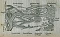
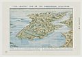
1554 map of the Dardanelles in Belon's Observations.
-
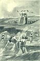
1915 Landing of French troops in Moudros (Lemnos island) during the Gallipoli Campaign.
-
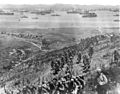
Landing at Gallipoli in April 1915.
-
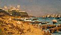
Anzac Cove.
-

The Sphinx overlooking Anzac Cove.
-
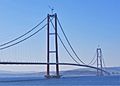
The Çanakkale 1915 Bridge on the Dardanelles strait, connecting Europe and Asia, is the longest suspension bridge in the world.
-
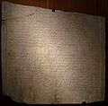
Marble plate with 6th century AD Byzantine law regulating payment of customs in the Dardanelles.
-
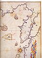
Historic map of the Dardanelles by Piri Reis.
-
Map of the Dardanelles drawn by G. F. Morrell, 1915, showing the Gallipoli peninsula and the west coast of Turkey, as well as the location of front line troops and landings during the Gallipoli Campaign.
-
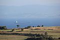
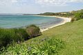
A view of the Dardanelles from Gallipoli peninsula.
-
A view of Çanakkale from the Dardanelles.
-
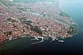
Aerial view of the city of Çanakkale.
-
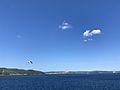
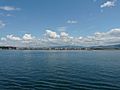
Dardanelles in 2021.


.jpg)
.jpg)


See also
 In Spanish: Dardanelos para niños
