Hemblington facts for kids
Quick facts for kids Hemblington |
|
|---|---|
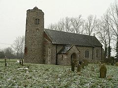
 All Saints' Church |
|
| Area | 1.17 sq mi (3.0 km2) |
| Population | 384 (2021 census) |
| • Density | 328/sq mi (127/km2) |
| OS grid reference | TG353115 |
| Civil parish |
|
| District |
|
| Shire county | |
| Region | |
| Country | England |
| Sovereign state | United Kingdom |
| Post town | NORWICH |
| Postcode district | NR13 |
| Dialling code | 01603 |
| Police | Norfolk |
| Fire | Norfolk |
| Ambulance | East of England |
| EU Parliament | East of England |
| UK Parliament |
|
Hemblington is a small village in the county of Norfolk, England. It is part of a civil parish, which is a type of local government area. The parish also includes the even smaller village of Pedham.
Hemblington is located about 2.8 miles (4.5 km) west of the town of Acle and 7.8 miles (12.6 km) east of the city of Norwich.
Contents
History of Hemblington
The name 'Hemblington' is very old and comes from the Anglo-Saxon period. It is from an Old English phrase that means "Hemele's settlement."
The Domesday Book
Way back in 1086, Hemblington was mentioned in the famous Domesday Book. This book was a huge survey of all the land in England, ordered by King William I. At that time, Hemblington was a small settlement with 39 households.
Hemblington Hall
The village is home to Hemblington Hall, a brick manor house built in the 1700s. It was originally the home of the Heath family.
A Strange Sighting
In 1997, a group of people using metal detectors reported seeing something strange in the sky. They described a UFO with flashing lights of different colors that suddenly vanished.
People and Place
According to the 2021 census, 384 people live in Hemblington. This is a small increase from 2011, when 332 people lived there.
All Saints' Church
Hemblington's parish church is called All Saints' Church. It is a very special building that dates back to the 1100s.
A Rare Round Tower
One of the most interesting things about the church is its round tower. It is one of only 124 round-tower churches left in Norfolk. Because it is so old and important, it has been a Grade I listed building since 1962. This means it is protected as a building of special historic interest.
The church is located just outside the main village. It holds a Sunday service once a month.
Art Inside the Church
Inside, you can see a beautiful font from the 1400s. In the 1930s, an art expert named Ernest William Tristram carefully repainted it to look like it did originally. He also restored a large wall painting of Saint Christopher, a Christian saint.
How the Village is Governed
For local elections, Hemblington is part of the Blofield with South Walsham ward in the Broadland district.
For national elections, the village is in the Broadland and Fakenham area. The Member of Parliament (MP) who represents this area is Jerome Mayhew of the Conservative Party. An MP's job is to represent the people of their area in the UK Parliament.
War Memorial
Inside All Saints' Church, two stone plaques serve as the village's war memorial. They honor the soldiers from Hemblington who died in the First and Second World Wars.
First World War (1914-1918)
| Rank | Name | Unit | Date of Death | Burial/Commemoration |
|---|---|---|---|---|
| Sjt. | William A. Evans | 8th Bn., Durham Light Infantry | 5 Nov. 1916 | Warlencourt British Cemetery |
| LCpl. | James Clare | 195th Coy., Machine Gun Corps | 7 Aug. 1917 | Menin Gate |
| Pte. | James Browne | 13th Bn., Royal Fusiliers | 14 Nov. 1916 | Thiepval Memorial |
Second World War (1939-1945)
| Rank | Name | Unit | Date of Death | Burial/Commemoration |
|---|---|---|---|---|
| SqLdr | George E. Weston DFC | No. 61 Squadron RAF | 1 Oct. 1942 | All Saints' Churchyard |
| FSgt. | Godfrey R. Weston | Royal New Zealand Air Force | 20 Apr. 1944 | All Saints' Churchyard |
| Gdsm. | Benjamin D. Barber | 1st Bn., Coldstream Guards | 30 May 1940 | Veurne Cemetery |
| Dvr. | Ronald Hylton | 15 Coy., R. Army Service Corps | 12 Jun. 1943 | Benghazi War Cemetery |
| Dvr. | Cyril W. Hylton | 838 Coy., R.A.S.C. | 4 May 1945 | Holten War Cemetery |
 | Isaac Myers |
 | D. Hamilton Jackson |
 | A. Philip Randolph |


