
Benghazi facts for kids
Quick facts for kids
Benghazi
بنغازي
|
|
|---|---|

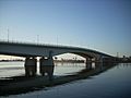
Benghazi seafront
|
|
| Nickname(s):
رَبّايِةْ الْذَايِحْ (Mother of Migrants) – الْمَدِينََه الْعَصِيّهْ (The Intractable City)
|
|

Benghazi
Location in Libya
|
|
| Country | |
| Region | Cyrenaica |
| District | Benghazi |
| Settled | as Euesperides (circa 525 BC) |
| Renamed | • Berenice (circa middle of the 3rd century BC) • Hesperides • Barneeq (circa middle of the 7th century AD) • Marsa ibn Ghazi (circa 16th century) • Bani Ghazi • Benghazi |
| Area | |
| • City | 314 km2 (121 sq mi) |
| Elevation | 2 m (7 ft) |
| Population
(2020)
|
|
| • City | 1,207,250 |
| • Density | 3,845/km2 (9,958/sq mi) |
| • Metro | 1,500,000 |
| Demonym(s) | Benghazian |
| Time zone | UTC+2 (EET) |
| Area code(s) | (+218) 61 |
| License Plate Code | 8 |
Benghazi is the second-largest city in Libya. It is also the biggest city in a region called Cyrenaica. In 2020, about 1.2 million people lived there. Benghazi is located on the Gulf of Sidra in the Mediterranean Sea, making it an important seaport.
A long time ago, around 525 BC, a Greek settlement called Euesperides was in this area. Later, in the 3rd century BC, it was rebuilt and renamed Berenice. This city grew and became important under the Romans. However, it became smaller during the Byzantine period before the Arabs took control.
After about 400 years of Ottoman rule, Italy took over Benghazi in 1911. Under Italian rule, Benghazi developed a lot, especially in the late 1930s. The city was heavily damaged during World War II as it changed hands many times. After the war, Benghazi was rebuilt and became a co-capital of the new Kingdom of Libya. But after a coup d'état in 1969 by Muammar Gaddafi, Benghazi lost its capital status. All government offices moved to Tripoli.
In 2011, an uprising against Muammar Gaddafi's government started in Benghazi. The city was taken by opponents of Gaddafi, who formed the National Transitional Council. In March 2011, Benghazi was a key point in the 2011 Libyan Civil War. The Libyan Army tried to attack the city, but local people and the French Air Force pushed them back. This allowed the rebellion to continue. By 2014, another civil war began in Libya. Benghazi saw heavy fighting until a ceasefire in 2020.
Today, Benghazi is still a major center for business, industry, transport, and culture in Libya. It has many important buildings, including the National Library of Libya.
Contents
History
Ancient Greek Settlement: Euesperides

Ancient Greeks settled in the Benghazi area in the late 7th century BC. They called their city Euesperides or Hesperis. It was likely founded by people from nearby Greek cities like Cyrene. The city was built near a lagoon that connected to the sea. Its name, Euesperides, came from the fertile land around it. This land was linked to the mythical Garden of the Hesperides. The old city was on a raised piece of land near what is now the Sidi-Abayd graveyard.
The city is first mentioned by the historian Herodotus around 515 BC. He wrote that the Persian army conquered the area up to Euesperides. The oldest coins from the city date back to 480 BC. These coins showed Delphi on one side and a silphium plant on the other. The silphium plant was a symbol of trade from Cyrenaica, used as a seasoning and medicine. These coins suggest the city had some independence from Cyrene.
Euesperides was in a difficult area, surrounded by unfriendly tribes. The Greek historian Thucydides wrote about a siege of the city in 414 BC. Libyan tribes attacked, but the Spartan general Gylippus and his fleet saved the city.
One king of Cyrene, Arcesilaus IV, tried to make Euesperides a safe place for himself. He brought new settlers after winning a chariot race in 462 BC. However, he was killed in Euesperides around 440 BC, ending his family's rule.
Around the mid-4th century BC, an inscription showed that the city had a government like Cyrene's. It had chief magistrates (leaders) and a council of elders. From 324 to 322 BC, the city supported a Spartan adventurer named Thibron. He tried to create his own kingdom but was defeated. The city then came under the control of Ptolemy I of Egypt.
In 246 BC, the region returned to Egyptian control when Berenice, daughter of the king of Cyrene, married Ptolemy III. Euesperides was moved to a new location, where modern Benghazi is now, and renamed Berenice. This move might have happened because the lagoons were filling with mud.
Roman Times
Modern Benghazi is located a bit southwest of the ancient Greek city of Berenice. This city was founded around 446 BC. It got the name Berenice in the 3rd century BC, named after Berenice, the daughter of the king of Cyrene. The new city was later called Hesperides after the mythical guardians of a western paradise. This name might also refer to green oases nearby.
Benghazi later became a Roman city and thrived for 600 years. After the 3rd century AD, it became the main center of Cyrenaica. By 642–643 AD, when the Arabs conquered it, it had become a small village.
During its successful period, Berenice became a Christian bishopric (a church district led by a bishop). Today, the Catholic Church lists Berenice as a titular see, which means it's a historical bishopric that no longer has a resident bishop.

Ottoman Rule
In the 13th century, Benghazi became important for trade between Genoese merchants and local tribes. In 16th-century maps, it was called Marsa ibn Ghazi (meaning "Port of the Son of Ghazi").
Benghazi's port was very important, so the Ottomans took control of it in 1578. It was ruled from Tripoli by the Karamanlis from 1711 to 1835. Then, it came under direct Ottoman rule until 1911. Greek and Italian sponge fishermen worked in its waters. In 1858 and 1874, Benghazi was hit hard by the bubonic plague.
Italian Colonial Rule


In 1911, the Italians invaded and conquered Benghazi. Many local people in Cyrenaica, led by Omar Mukhtar, fought against the Italian occupation.
In the early 1930s, the resistance ended. The Italians, under governor Italo Balbo, tried to make the local people feel more connected to Italy. They built new villages for Cyrenaicans with health services and schools.
By the late 1930s, more than 20,000 Italian colonists lived in Cyrenaica, mostly around Benghazi. In 1939, over 35% of Benghazi's population was Italian. This led to a big economic boom in Benghazi in the late 1930s. The city became modern with a new airport, railway station, seaplane station, and a bigger port. There were plans for a new railway to Tripoli, but World War II stopped these projects.
World War II
During World War II, Benghazi changed hands many times. British forces captured it from the Italians in February 1941. Then, the Axis powers, led by German General Erwin Rommel of the German Africa Corps, recaptured it in April.
The British took it again in December, but Rommel's Afrika Corps took it back in January 1942. After the important Second Battle of El Alamein in Egypt, the British, led by General Bernard Montgomery, defeated the Afrika Corps. The Axis forces retreated through Benghazi for the last time. On November 20, the British Eighth Army captured Benghazi and held it.
In August 1943, US planes took off from Benina airport near Benghazi. They attacked the Ploiești oil refineries in Romania with 178 B-24 bombers. This was called Operation Tidal Wave.
Modern Benghazi

Benghazi was heavily bombed in World War II. Later, with Libya's new oil wealth, it was rebuilt into a modern city. It became the capital of the Emirate of Cyrenaica (1949–1951) under Idris Senussi I. In 1951, Cyrenaica joined with other regions to form the independent Kingdom of Libya. Both Benghazi and Tripoli were capital cities.

Benghazi lost its capital status after a coup d'état in 1969. This was led by Muammar Gaddafi. All government offices moved to Tripoli. Even though King Idris was forced to leave, many people in Cyrenaica still supported his family. This was clear when the government demolished the football stadium of Alahly Benghazi S.C. in 2000 after protests.
On April 15, 1986, US Air Force and Navy planes bombed Benghazi and Tripoli. President Ronald Reagan said Libya was responsible for attacks against the United States.
The 2011 Revolution


In February 2011, peaceful protests started in Benghazi. They were met with force by Gaddafi's army. This violence made people fight back to overthrow Gaddafi in The Libyan Revolution. Hundreds of people were killed in these protests.

Many protesters used the old Libyan flag from the Kingdom of Libya. They also carried pictures of King Idris I. Benghazi and Cyrenaica have always been strongholds for the royal Senussi family.
By February 21, the opposition largely controlled the city. The mayor, Huda Ben Amer, had fled. Residents organized to manage traffic and collect trash. By February 24, a committee of lawyers and local leaders was formed to run the city. They also started local radio stations and a newspaper.
From February to August 2011, Benghazi was the temporary headquarters of the National Transitional Council. This group was led by former justice minister Mustafa Abdul Jalil.
On March 19, Gaddafi's forces almost defeated the rebellion by attacking Benghazi. But they were pushed back the next day when NATO forces intervened. This was allowed by United Nations Security Council Resolution 1973 to protect civilians.
On June 1, a car bomb exploded near the Tibesti Hotel. A rebel spokesman called it a "cowardly act." People started chanting against Gaddafi.
In May 2012, Benghazi residents voted in their first local elections since the 1960s. Many people voted.
2012 Attack on U.S. Diplomatic Mission
On September 11, 2012, the U.S. diplomatic mission in Benghazi was attacked by armed groups. During these attacks, U.S. Ambassador J. Christopher Stevens and three other Americans were killed. Several others were injured.
Second Libyan Civil War
After the second Libyan Civil War began in 2014, Benghazi saw heavy fighting. The Libyan National Army and the House of Representatives fought against other groups. Much of the city center was damaged during this time. The LNA declared the city cleared of militants in July 2017. The last militant-held area was captured in December 2017.
On October 23, 2020, a "permanent ceasefire agreement" was reached for all of Libya. This agreement required all foreign fighters to leave within three months. A joint police force would patrol disputed areas. The first commercial flight between Tripoli and Benghazi happened that same day. In March 2021, a temporary unity government was formed. This government was meant to stay until a new election, but the election has been delayed.
City Divisions


Benghazi District is one of Libya's 22 shabiyahs, which are like administrative areas.
In 2022, the Libyan government created 18 provinces. Benghazi is one of these provinces.

Benghazi is also divided into 32 smaller administrative areas called Basic People's Congresses. These areas have their own local responsibilities. Some of these areas include:
|
|
|
Population and People
Who Lives in Benghazi?

Benghazi has a mix of different people, like other cities in Libya. Most people in eastern Libya, including Benghazi, have traditionally been of Arab descent. More recently, many immigrants from other parts of Africa and Egypt have moved to Benghazi. There is also a small Greek community. Some families in Benghazi even have Cretan surnames, from the nearby Greek island of Crete. A few Italian families also remain from the time before World War II.
Historically, most Libyans in Benghazi were of Berber descent. Then, in the 11th century, Arab tribes called Sa'adi from the Banu Sulyam moved to Cyrenaica. The Barghathi tribe controlled Benghazi and its surrounding areas. In modern times, many Libyans from other parts of the country have moved to Benghazi. This includes people from Misrata. Benghazi is known as a welcoming city. Local Bedouins call it 'Benghazi rabayit al thayih', which means 'Benghazi raises the lost'. This is because many immigrants who arrived with little money were helped by the local people.
Religion in Benghazi

The main religion in Benghazi is Islam. Almost everyone in the city is a Sunni Muslim. During Islamic holidays like Ramadan, most people do not eat or drink during the day. Restaurants are usually empty then, except for some visitors. Alcohol is not allowed in Benghazi or anywhere in Libya. Family life is very important in Benghazi. Most young people live at home until they get married, though this is slowly changing. Many Muslims in Benghazi follow the traditional Maliki school of Islamic law. The Senussi order, which the royal family came from, has always had strong support in Benghazi and Cyrenaica.
There are many mosques in Benghazi for Muslims. The oldest and most famous ones, like the Atiq and Osman mosques, are in the old part of the city.
There is also a small Christian community. The Apostolic Vicariate of Benghazi serves about 4,000 Latin Catholics. There is also a Coptic Orthodox church for Egyptian Copts.
Jewish people used to live in Benghazi, like in other parts of Libya. They lived there from Roman times until 1967. Most of them left after some unrest following the 1948 Arab–Israeli War. Today, there are no Jewish people left in Libya.
Learning and Schools

Libya's oldest university is the University of Libya. It was started in 1955. It was first in the royal Al Manar Palace. Later, it got its own campus in 1968. It then split and became known as University of Benghazi. There are also some private universities, like Libyan International Medical University.
Education in Benghazi, like all of Libya, is required and paid for by the government. Children must go to school until ninth grade. There are many public primary and secondary schools in the city. There are also some private schools.
International schools in Benghazi include:
- International School Benghazi
- Benghazi European School
- British School in Benghazi
Geography

Benghazi is part of a region called Cyrenaica. This region also includes the Jebel Akhdar (Green Mountain) and a coastal plain. Cyrenaica is surrounded by desert on three sides. This meant that in ancient times, the easiest way to connect with other civilizations was across the Mediterranean Sea. Crete and Greece are only about 400 km away.
Benghazi is surrounded by dry, flat land called "barr" or steppe. The Jebel Akhdar, or "Green Mountain," is just north of Benghazi to the east. Here, the plants and weather are more like the Mediterranean, not the desert. A large part of the western Jebel Akhdar is a fertile plain called Marj. Further east, the Jebel Akhdar rises higher, often with thick woods and ravines. This area gets a lot of rain, especially around Cyrene. The soil in Benghazi is a rich red color and very clayey. Strong, dusty winds called Sirocco are common, so many streets and buildings can get dusty.
North of the city, below steep cliffs, is a narrow strip of Mediterranean farmland. Olives and other fruits and vegetables grow here. To the south, the forests and farms turn into juniper bushes and pre-desert scrubland.
Benghazi district is surrounded by the Hizam Al Akhdar district on land.
Parks and Green Spaces

Benghazi doesn't have a lot of green space for each person, but it does have some public parks. The most famous is the zoo and theme park in Al-Fuwayhat, also known as Benghazi Zoo. Locals call it al-Bosco, which is Italian for "wood." This park has a zoo with wild cats, monkeys, elephants, and birds. It also has a small theme park with rides. It's a very popular park, especially on holidays and for school trips.
On Gamal Abdel Nasser Street, there is 23 July Park. This is another large green area facing the Tibesti Hotel and the waterfront. Teenagers and families enjoy this park, especially on Thursday nights. Another big and popular park is al-Buduzira in North Benghazi. This park surrounds a natural lake and is more wild than city parks. Part of al-Buduzira is a water park with big slides. The southern part has picnic areas, which are popular in summer.
Climate
Benghazi has a warm semi-arid climate. This means it has hot, dry, and long summers. Winters are mild to cool with some rain. The yearly rainfall is low, about 270 mm (10.6 inches). The city gets extra water from underground water sources in southern Libya. This water is brought through the Great Manmade River.
| Climate data for Benghazi (Benina International Airport) (1991–2020) | |||||||||||||
|---|---|---|---|---|---|---|---|---|---|---|---|---|---|
| Month | Jan | Feb | Mar | Apr | May | Jun | Jul | Aug | Sep | Oct | Nov | Dec | Year |
| Record high °C (°F) | 26.3 (79.3) |
31.7 (89.1) |
38.0 (100.4) |
39.9 (103.8) |
44.8 (112.6) |
45.6 (114.1) |
43.0 (109.4) |
44.0 (111.2) |
42.1 (107.8) |
39.0 (102.2) |
37.2 (99.0) |
31.0 (87.8) |
45.6 (114.1) |
| Mean daily maximum °C (°F) | 16.6 (61.9) |
17.0 (62.6) |
20.5 (68.9) |
24.4 (75.9) |
28.3 (82.9) |
31.0 (87.8) |
31.4 (88.5) |
32.0 (89.6) |
31.1 (88.0) |
28.0 (82.4) |
22.9 (73.2) |
18.3 (64.9) |
25.1 (77.2) |
| Daily mean °C (°F) | 12.9 (55.2) |
13.0 (55.4) |
15.5 (59.9) |
18.9 (66.0) |
22.7 (72.9) |
25.5 (77.9) |
26.5 (79.7) |
27.1 (80.8) |
26.1 (79.0) |
23.1 (73.6) |
18.5 (65.3) |
14.6 (58.3) |
20.4 (68.7) |
| Mean daily minimum °C (°F) | 9.2 (48.6) |
9.0 (48.2) |
10.5 (50.9) |
13.5 (56.3) |
17.1 (62.8) |
20.1 (68.2) |
21.6 (70.9) |
22.3 (72.1) |
21.1 (70.0) |
18.3 (64.9) |
14.2 (57.6) |
10.9 (51.6) |
15.6 (60.1) |
| Record low °C (°F) | −2.7 (27.1) |
−2.7 (27.1) |
−2.7 (27.1) |
3.9 (39.0) |
6.1 (43.0) |
10.0 (50.0) |
14.8 (58.6) |
14.4 (57.9) |
10.0 (50.0) |
10.8 (51.4) |
5.6 (42.1) |
−3.0 (26.6) |
−3.0 (26.6) |
| Average precipitation mm (inches) | 62.4 (2.46) |
47.3 (1.86) |
25.9 (1.02) |
4.8 (0.19) |
2.9 (0.11) |
0.3 (0.01) |
0.0 (0.0) |
0.3 (0.01) |
4.1 (0.16) |
16.0 (0.63) |
31.3 (1.23) |
69.3 (2.73) |
264.6 (10.42) |
| Average precipitation days (≥ 1.0 mm) | 8.9 | 7.5 | 3.7 | 1.3 | 0.8 | 0.1 | 0.0 | 0.3 | 0.9 | 2.5 | 4.8 | 9.7 | 40.5 |
| Average relative humidity (%) | 73.7 | 71.7 | 64.4 | 56.2 | 53.8 | 56.4 | 64.5 | 65.6 | 62.1 | 63.4 | 66.1 | 71.7 | 64.1 |
| Average dew point °C (°F) | 7.8 (46.0) |
7.3 (45.1) |
7.6 (45.7) |
8.3 (46.9) |
10.9 (51.6) |
14.5 (58.1) |
18.4 (65.1) |
19.3 (66.7) |
17.0 (62.6) |
14.4 (57.9) |
11.0 (51.8) |
8.8 (47.8) |
12.1 (53.8) |
| Mean monthly sunshine hours | 201.5 | 220.4 | 244.9 | 264.0 | 325.5 | 336.0 | 390.6 | 365.8 | 291.0 | 248.0 | 222.0 | 170.5 | 3,280.2 |
| Mean daily sunshine hours | 6.5 | 7.8 | 7.9 | 8.8 | 10.5 | 11.2 | 12.6 | 11.8 | 9.7 | 8.0 | 7.4 | 5.5 | 9.0 |
| Source 1: NOAA | |||||||||||||
| Source 2: Deutscher Wetterdienst (extremes 1945–1977), Arab Meteorology Book (sun only) | |||||||||||||
Economy

Benghazi is a main economic center in eastern Libya. Its important port helps Libya import many foods and products. Benghazi is also a hub for industry and business. Major goods made here include processed food, textiles, and construction materials like cement. A large cement factory is in al-Hawari. Food processing uses local fish, imported goods, and produce from nearby farms. These farms grow grains, dates, olives, and raise animals for wool and meat.
Money and banking are also important. The Libyan Bank of Commerce and Development has offices in Benghazi. The Central Bank of Libya also has an office in the city center.
The oil industry is a big part of the city's business. Large national companies like Al-Brega Oil Marketing Company and the Arabian Gulf Oil Company employ many people. In recent years, more stores have opened, including international brands like United Colors of Benetton, H&M, and Nike.
Tourism in Libya is still new, but it's growing in Benghazi. Most tourists use Benghazi as a starting point to see the Greek ruins in Cyrene or to go on desert trips to Kufra. The main hotels are the Tibesti Hotel and Uzu Hotel. More hotels have opened recently due to higher demand. Local crafts are sold in the city's many markets, called souks.
Skanska built many speedways and overpasses after the 1969 Libyan revolution. This made it easier to move goods between Benghazi and other cities. Benghazi's air travel uses Benina International Airport. There are many daily flights to Tripoli and other cities in Africa, Asia, and Europe.
In April 2012, Libya's economy ministry planned to create a free trade area in Benghazi. After the civil war ceasefire, business in Libya has increased. In 2021, the Libyan Business Council organized the Benghazi International Trade Fair.
Getting Around: Transport

Benghazi is a key transport hub in Eastern Libya. It is an important city on the main coastal road that crosses the country. The city has a well-designed system of roads, bridges, and underpasses. However, traffic jams and poorly maintained streets can happen. A microbus system covers many areas of the city. National and international bus services also leave from the central bus station. In 2010, work began on a new railway network. This network will connect Benghazi to major cities in western Libya.
Benina International Airport handles flights within Libya and to other countries.
The Benghazi port is very important for the region. It allows goods and food products to be imported and exported.
The city's road network is generally well planned. It has highways, overpasses, ring roads, and underpasses for moving goods and vehicles. However, roads are not always well kept. They often have missing or unclear road markings, and potholes. In recent years, more people own cars, leading to traffic jams and a lack of parking. Road accidents have also increased. A study found that during the 2011 conflict, road accidents decreased, but injuries were more severe.
Benghazi does not have a formal public transport system. However, a popular microbus system has grown. These buses run on fixed routes, and passengers can get on or off anywhere. Most microbuses stop at Al-Funduq. National and international bus services also leave from Al-Funduq. They have regular trips to Tripoli and international services to Cairo, Amman, and Damascus.
Until the 1960s, there were two small railways built by the Italians. They connected Benghazi to Barce and Soluch. More recently, plans for a large railway network were supported by Gaddafi. Work started in September 2008 on a new network that would connect to cities like Sirte. Russian Railways is building this project. In the future, there might be rail links to Tunisia and Egypt, creating a North African coastal rail network.
City Layout
.JPG)
Benghazi is divided into many neighborhoods. Some were built during Italian colonial rule, and many have grown with modern city expansion. These neighborhoods differ in wealth, culture, history, and social feel. Generally, the city is divided into these areas:
- Central Benghazi (called al-Blaad by locals): This includes the old city and the medina. It has most of Benghazi's historical sites and popular tourist spots. The city's theaters, libraries, best clothing stores, markets, and old mosques are here. The Italian quarter is also in the center.
- Central Districts: These areas circle downtown. They include Al-Sabri, Sidi Abayd, Sidi Hsayn, Al-Berka, Al-Salmani, Al-Hadaa'ik, Al-Fuwayhat, and Al-Keesh. They are mostly residential and commercial areas.
- Central Suburbs: These are almost entirely residential and feel like small towns. Al-Quwarsha is a good example.
- Coastal Districts: These are where Benghazi's beaches are found, especially the southern districts. Some parts, like Qanfuda, have become popular for living. These areas are mainly for recreation. Many beach condominium resorts, called chalets, have been built here.
- Distant Suburbs: These include Gimeenis, Benina, and Sidi Khalifa.
Culture
Benghazi is one of Libya's cultural centers. It is a base for tourists, visitors, and students in the region. Throughout its history, Benghazi has developed somewhat independently from Tripoli, the capital. This has made Benghazi's culture more Arab in nature than Tripoli's. Many immigrants from Egypt, Iraq, Palestine, Sudan, and Syria have also influenced the city's culture.
The city center has local theaters and the Dar al-Kutub National Library. Here you can find works by local writers like Sadeq Naihoum. Different building styles show the various empires that have ruled the city. Sports are also important in Benghazi. Two of Libya's most successful football clubs are based here.
Building Styles
Benghazi has many different building styles. These styles show the many times the city has changed rulers. Arab, Ottoman, and Italian rule have all shaped the streets, buildings, and neighborhoods.
You can find ancient Greek and Roman ruins near the Italian lighthouse. There are parts of a 3rd-century BC wall built by the Greeks. You can also see four Roman houses and six wine vats. A Byzantine church with a mosaic is also on the site. These ruins were the northern part of the ancient city, which is now buried under the modern city.
The next oldest part of the city is the Medina quarter. This area started growing under Medieval Arab rule and is still here today. It stretches from the northern harbor shores. The heart of the medina is Maydan al-Hurriya (Freedom Square). To its northeast is the covered Souq al-Jareed market.

The largest Ottoman building in Benghazi is the late 19th-century Ottoman palace in El-Berka. It was built during the rule of Rashid Pasha II. The front was finished in 1895, and the sides were added later by the Italians. This white and green building has 360 rooms. It is located where Gamal Abdel Nasser Street meets al-Saqzali Street.
The house of Omar Pasha Mansour El Kikhia is a good example of Ottoman home architecture. It has balconies, stone arches, and an open courtyard with a fountain. This home was recently restored and turned into the Bait-al Medina al-Thaqafi museum.

Benghazi came under Italian rule in the early 1900s. Some buildings from this time still exist. They show Italian and modern colonial styles. In the 1920s, buildings in Benghazi mixed Western ideas with Eastern architecture. An example is the Municipal palace, built in 1924. It stands in Maydan al-Hurriya (Freedom Square). This building combines Moorish arches with Italian designs. Italians also made the first city plan for Benghazi in the 1930s, with a new railway station and promenade.
The largest colonial building from the Italian period is the Benghazi Cathedral. It is in Maydan El Catedraeya (Cathedral Square). It was built in the 1920s and has two large domes.
Benghazi was heavily bombed during World War II. So, most buildings in the city are modern. The main business area was built mostly in the 1960s and 1970s with Libya's new oil money. The tallest building in Benghazi is the Tibesti Hotel, built in 1989. Another important modern building is the Da'wah al-Islamiyah Building. It has unique cubes stacked like a pyramid.
Important colonial buildings designed during Italian rule include the Berenice Cinema. It was designed by Marcello Piacentini and Luigi Piccinato in 1928. It is currently being renovated.
Sports in Benghazi
Benghazi is Libya's second-largest city, so it has some of the best sports facilities. The city has various sports centers, including football stadiums and beach clubs for water sports. Benghazi has hosted many national and international sports events, like the African Cup of Nations.
Football is the most popular sport in Benghazi. Two of Libya's most successful football clubs, Al-Ahly Benghazi and Al-Nasr Benghazi, are based here. Together, they have won the Libyan Premier League five times. The most important football event in Benghazi was the 1982 African Cup of Nations. The city hosted six group games and a semifinal in the March 28 Stadium, Libya's second-largest stadium. Benghazi will likely host more games when Libya hosts the African Cup of Nations again.
The largest sports center in Benghazi is the Medina al-Riyadhia (Sports City). This complex is just south of the city center. It has the 28 March Stadium and the Slayman al Tharrat basketball stadium. Several matches of the 2009 FIBA Africa Championship were held there. The complex also has a sports hall for indoor sports, a tennis stadium, and several small tennis courts. The facility was built in the 1950s and is being updated. As of 2009, the 28 March Stadium was being torn down to build a new 45,000-seat stadium. A second smaller stadium was also planned. The whole site was to be redeveloped before its reopening in 2011 for the 2013 African Nations Cup.
The eastern suburb of Sidi Khalifa has a place for horse riding. The 'Martyrs of Benghazi's Riding Club' has female members who compete in sports.
Benghazi is a coastal city, so its beaches are important for sports. The coast at Jeliana has the Milaha Beach Club. Wind surfing and swimming are popular water sports. There are also several contact sport clubs in the city. Judo and taekwondo are popular men's sports. Recently, rugby sevens has become very popular with three clubs in the area. Gyms have also become more common as Libyans care more about healthy living.
Food and Drink
Food and drink are very important to the culture of Benghazi, like in the rest of Libya. Many dishes and ingredients are passed down through families. The main ingredients are olive oil, garlic, palm dates, grains, and milk. These foods are natural to the area and common in North Africa and the Mediterranean. Tea is also a big part of Libyan food culture. Tea from Benghazi has a unique, thick, bitter taste. Drinking tea is a social activity that friends and family share.
Benghazi has many special dishes that can be made at home. Bazin (bread) is one of the most famous. Bazin is a dish with a small loaf of heated dough and a meat or vegetable sauce. You can tear the dough into pieces and dip them into the sauce. This dish uses important ingredients like garlic and oil. A common dessert in Benghazi is deep-fried dates, often served with milk.
Notable People
Some famous people from Benghazi include:
- Khadījah Jahamī, a broadcaster
- Taha El Sherif Ben Amer, a Minister of Transport in Libya
- Amal Bayou, a microbiologist and politician
Images for kids
-
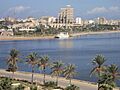
Benghazi seafront
-
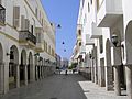
Omar Al Mukhtar Street in the Italian quarter.
-
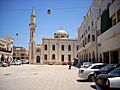
The Atiq Mosque in Maydan al-Baladiya.
-
The cubic tower block Al Da'waa al-Islamiya.
-
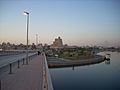
The Jeliana Bridge.
See also
 In Spanish: Bengasi para niños
