
Herat Province facts for kids
Quick facts for kids Herat (هرات) |
|
| Province | |
| Country | Afghanistan |
|---|---|
| Capital | Herat |
| - coordinates | 34°00′N 62°00′E / 34.0°N 62.0°E |
| Area | 54,778 km² (21,150 sq mi) |
| Population | 1,762,157 |
| Timezone | UTC+4:30 |
| Main language | Dari (Persian) Pashto |
Herat (in Persian and Pashto: هرات) is one of the 34 provinces in Afghanistan. It is located in the southwestern part of the country. The main city and capital of the province is also called Herat.
Contents
A Glimpse into Herat's History
Herat has a very long and interesting history. This area was once part of a larger region known as Greater Khorasan. Over many centuries, different powerful groups ruled Herat. These included the Tahirids, Saffarids, Samanids, Ghaznavids, Ghurids, Ilkhanates, Timurids, and Safavids.
In the early 1700s, Herat became part of the Afghan Hotaki dynasty. Later, it joined the Durrani Empire. This shows how important Herat has been throughout history for many different empires and kingdoms.
People of Herat Province
About 1,762,157 people live in Herat Province. The main languages spoken here are Dari (Persian) and Pashto.
Sports in Herat
Football (also known as soccer) is a very popular sport in Herat Province. Many people enjoy playing and watching it. Cricket is also becoming more popular among the people here.
 |
Mary Province, |
Badghis Province | |
|
| Razavi Khorasan Province, |
Ghor Province | |||
| South Khorasan Province, |
Farah Province |
Images for kids
-
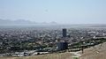
City of Herat, which is the capital of the province.
-
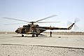
An Afghan Air Force Mi-17 helicopter sits on the ramp at Shindand Air Base in 2011.
-
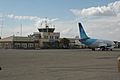
Herat International Airport
-
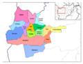
Districts of Herat


See also
 In Spanish: Provincia de Herāt para niños
