
Highland Creek (Toronto) facts for kids
Quick facts for kids Highland Creek |
|
|---|---|

Highland Creek and its associated valley
|
|

Location of the mouth of the creek in Toronto
|
|
| Country | Canada |
| Province | Ontario |
| Municipality | Toronto |
| Physical characteristics | |
| Main source | Hydro One right of way, near Brimley Road & McNicoll Avenue 186 m (610 ft) 43°48′54″N 79°16′51″W / 43.81500°N 79.28083°W |
| River mouth | Lake Ontario 75 m (246 ft) 43°46′0″N 79°08′41″W / 43.76667°N 79.14472°W |
| Length | 29.1 km (18.1 mi) |
| Basin features | |
| Tributaries |
|
Highland Creek is a river in the Scarborough area of Toronto, Ontario. It flows into Lake Ontario at the eastern edge of the Scarborough Bluffs. This creek is home to many kinds of fish. You can find trout, carp, bass, and salmon here.
Like most rivers in Toronto, Highland Creek winds through a deep valley. This valley was carved out by glaciers after the last Ice Age. The entire area that drains into Highland Creek, called its watershed, is mostly within Scarborough.
Contents
What's in a Name?
The original name for Highland Creek came from the Mississauga people. In 1796, a British surveyor wrote down their name for the river: Yat-qui-i-be-no-nick. This means "creek comes out under high."
We don't know for sure how it got the name "Highland Creek." Some people think it's because the area reminded early settlers of the Highlands of Scotland. Many of these settlers came from Scotland.
How Highland Creek Flows
Highland Creek is made up of four main parts, or branches. These branches flow from west to east across Scarborough. They all eventually join together before reaching Lake Ontario.
The North-West Branch
This branch starts from a pipe near Finch Avenue East. It flows south and then southeast. Much of this branch was straightened and lined with concrete in the 1970s. This was done to control mosquitoes. This part of the creek is about 3.4 km (2.1 mi) long.
The West Branch
The west branch begins near Brimley Road and McNicoll Road. This is the furthest north part of the entire Highland Creek system. It flows southeast under several roads. Like the north-west branch, much of its upper part was also straightened and lined with concrete.
However, a section of about 1.6 km (1.0 mi) has been restored to a more natural shape. It now has gentle curves and shallow pools. This branch is about 7.7 km (4.8 mi) long.
The Central Branch

The central branch starts northwest of Middlefield Road and Finch Avenue East. It flows southeast and then east. After passing under Highway 401, it flows in a natural bed and valley.
This branch is joined by the West Highland Creek in Morningside Park (Toronto). It then continues through the park and under several major roads. Finally, it meets the east branch before flowing into Lake Ontario. This is the longest branch, at about 13.5 km (8.4 mi).
The East Branch
The east branch starts south of Highway 401, near Meadowvale Road. It flows south and southeast. Unlike the other branches, this one does not flow through deep valleys. It is about 4.5 km (2.8 mi) long. It joins the central branch just before reaching Lake Ontario.
Wetlands at the Mouth of the Creek
Where Highland Creek meets Lake Ontario, there are four important wetland areas. These wetlands cover about 7.6 hectares (19 acres) (about 19 acres). One of these, Stephenson’s Swamp, is very special. It is a rare type of forest swamp that used to be common along Lake Ontario.
These wetlands are important breeding grounds for unusual animals. These include the blue-gray gnatcatcher (a small bird) and the yellow-spotted salamander.
Smaller Creeks that Join Highland Creek
Highland Creek has several smaller streams, called tributaries, that flow into it.
- West Highland Creek
- Bellamy Ravine Creek
- Southwest Highland Creek
Highland Creek's Past
Like many river valleys in Toronto, the Highland Creek area has signs of early First Nations people. In 2005, a dig near the creek's mouth found tools from thousands of years ago. This shows that people lived and made tools here a very long time ago.
Highland Creek's deep valley used to make it hard to build roads and bridges across it. For a long time, the only easy way to cross was at Military Trail. It wasn't until the mid-1900s that longer bridges were built. These new bridges made it easier to cross the wide, deep valley.
In the 1940s and 1950s, a new town was planned in the valley. But in 1954, Hurricane Hazel caused a huge flood. Most of the new town was washed away.
Communities Along the Creek
The name Highland Creek is also used for a neighborhood. This neighborhood is located on the east side of the creek, near Old Kingston Road. Across the valley from this area is another neighborhood called West Hill. It got its name because it sits on the high ground above the creek valley.
Images for kids
-
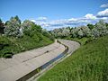
The central branch at Middlefield Road, near its point of origin.
