Hillsboro, Loudoun County, Virginia facts for kids
Quick facts for kids
Hillsboro, Virginia
|
|
|---|---|
| Town of Hillsboro | |

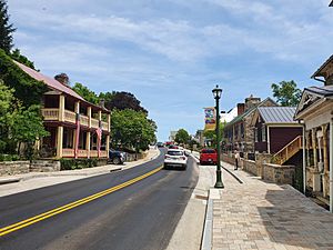
Charles Town Pike (Virginia State Route 9) in Hillsboro
|
|
| Country | |
| State | |
| County | Loudoun |
| Area | |
| • Total | 0.27 sq mi (0.69 km2) |
| • Land | 0.27 sq mi (0.69 km2) |
| • Water | 0.00 sq mi (0.01 km2) |
| Elevation | 551 ft (168 m) |
| Population
(2020)
|
|
| • Total | 114 |
| • Density | 430.2/sq mi (166.1/km2) |
| Time zone | UTC−5 (Eastern (EST)) |
| • Summer (DST) | UTC−4 (EDT) |
| ZIP codes |
20132, 20134
|
| Area code(s) | 540 |
| FIPS code | 51-37288 |
| GNIS feature ID | 1499563 |
Hillsboro is a small town in Loudoun County, Virginia, United States. It's a quiet, rural place. In 2020, about 114 people lived there.
Contents
Discover Hillsboro, Virginia
Where is Hillsboro Located?
Hillsboro is in the western part of Loudoun County. It sits at the eastern end of a place called Hillsboro Gap. This is where the North Fork of Catoctin Creek flows through Short Hill Mountain. This mountain is part of the Blue Ridge Mountains in Virginia.
The town is about 4 miles (6.4 km) east of the border with West Virginia. It's also about 11 miles (18 km) northwest of Leesburg. Leesburg is the main town, or county seat, for Loudoun County.
Hillsboro covers a total area of about 0.27 square miles (0.7 square kilometers). All of this area is land.
Getting Around Hillsboro
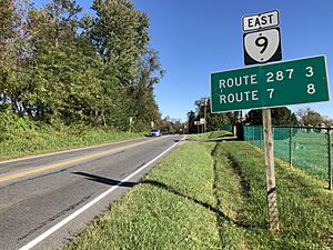
The main road that goes through Hillsboro is Virginia State Route 9. It's also known as Charles Town Pike. This road is important for connecting Hillsboro to other places.
If you go northwest on SR 9, you can reach Charles Town (about 12 miles away) and Martinsburg, West Virginia (about 26 miles away). SR 9 also connects to Interstate 81, a major highway.
If you go southeast on SR 9, it connects with Virginia State Route 7. SR 7 continues to Leesburg and then all the way to Alexandria. Along the way, SR 7 connects with other big highways like Interstate 495, Interstate 66, and Interstate 395.
Who Lives in Hillsboro?
| Historical population | |||
|---|---|---|---|
| Census | Pop. | %± | |
| 1870 | 246 | — | |
| 1880 | 137 | −44.3% | |
| 1890 | 156 | 13.9% | |
| 1900 | 131 | −16.0% | |
| 1910 | 138 | 5.3% | |
| 1920 | 131 | −5.1% | |
| 1930 | 119 | −9.2% | |
| 1940 | 115 | −3.4% | |
| 1950 | 129 | 12.2% | |
| 1960 | 124 | −3.9% | |
| 1970 | 135 | 8.9% | |
| 1980 | 115 | −14.8% | |
| 1990 | 72 | −37.4% | |
| 2000 | 96 | 33.3% | |
| 2010 | 80 | −16.7% | |
| 2020 | 114 | 42.5% | |
| U.S. Decennial Census | |||
The number of people living in Hillsboro has changed over the years. The table above shows how the population has grown and shrunk since 1870. In 2020, the population was 114 people.
In 2000, there were 96 people living in Hillsboro. Most of the people were White (about 97%), and a small number were African American (about 3%).
The average age of people in Hillsboro in 2000 was 41 years old. About 20% of the population was under 18. About 13.5% of the people were 65 or older.
Famous People from Hillsboro
Some interesting people have connections to Hillsboro:
- Byron Farwell was the mayor of Hillsboro for three terms. A mayor is the leader of a town or city's government. He served from 1976 to 1982. Other mayors included Sandy Muir and Alix Spaith.
- John B. Funk (1905–1993) was a politician from Maryland. He even served as the Secretary of State for Maryland.
- The family of Mary Virginia Gaver owned a woolen mill in Hillsboro in the 1800s. Mary Virginia Gaver later became a very important leader in library science.
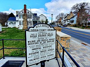
- Susan Koerner Wright, the mother of the famous Wright brothers, was born near Hillsboro. The Wright brothers were pioneers in aviation and invented the first successful airplane.
See also
 In Spanish: Hillsboro (Virginia) para niños
 | Jackie Robinson |
 | Jack Johnson |
 | Althea Gibson |
 | Arthur Ashe |
 | Muhammad Ali |


