History of the East Riding of Yorkshire facts for kids
The East Riding of Yorkshire is a special area in England. It's a local government district, which means it has its own council to manage things like schools and roads. It's also a "ceremonial county," which is a traditional area used for things like royal visits.
This area gets its name from the historic East Riding of Yorkshire. Long ago, Yorkshire was divided into three main parts called "ridings": the East, North, and West Ridings. These ridings were important parts of Yorkshire until 1974. From 1974 to 1996, the area we now call the East Riding of Yorkshire was part of a larger region called Humberside.
Contents
Where is the East Riding of Yorkshire?
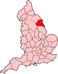
As a ceremonial county, the East Riding of Yorkshire shares borders with North Yorkshire, South Yorkshire, and Lincolnshire. It also includes the city of Kingston upon Hull, which is a separate local authority.
As a district, it borders North East Lincolnshire (across the Humber river), North Lincolnshire, Hull, Doncaster, Selby, York, Ryedale, and Scarborough.
How the East Riding was Governed Over Time
The East Riding has a very long history of how it was managed. Unlike most counties in Britain, which were divided into "hundreds," Yorkshire was first split into its three "ridings." Then, each riding was further divided into smaller areas called "wapentakes." Even though wapentakes are not used today, they are a key part of Yorkshire's history.
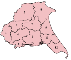
The East Riding of Yorkshire had seven main wapentakes. Some of these were even divided into smaller parts. Here's a look at them:
|
1. Ouse and Derwent |
7. Harthill – Bainton Beacon Division |
After the English Restoration (when the monarchy was brought back), each riding had its own special representative of the Crown and its own local courts.
Changes in Local Government
In the 1800s, for counting people and managing poor relief, the East Riding of Yorkshire was set up as a "registration county." This area included the city of York. These poor law areas later became the basis for "rural sanitary districts" in 1875, which helped manage public health.
In 1889, a county council was created for the East Riding of Yorkshire. This council managed the "administrative county," which covered most of the historic riding but did not include Hull. Hull was a "county borough," meaning it was a large town that managed itself separately. Besides Hull, the East Riding had two "municipal boroughs" (smaller self-governing towns): Beverley and Hedon.
After 1894, the rest of the administrative county was divided into "rural districts" (countryside areas) and "urban districts" (towns). These districts were based on the older sanitary districts. Some new urban districts were formed, like Cottingham, Great Driffield, Filey, Hessle, Hornsea, Norton, Pocklington, and Withernsea.
Hull was the only large town in the East Riding and a very important port. Its population grew a lot in the late 1800s. Other towns like Bridlington stayed smaller. By 1971, the East Riding had over 500,000 people. In comparison, the West Riding had nearly 4 million people, and the North Riding had about 700,000. Beverley was once a very important town with a college and a large church called Beverley Minster. It became the county town for the East Riding in 1892.

Bridlington became a municipal borough in 1899. It became a popular "resort town" (a place people visit for holidays), just like Hornsea and Withernsea.
In 1935, the county districts were changed again. Some rural districts were combined or split. For example, a new urban district called Haltemprice was created to cover the growing towns west of Hull.
The End of the Old System
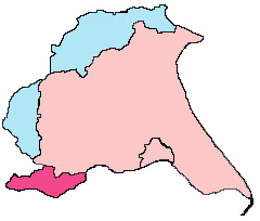
Both the administrative county and the traditional Lieutenancy were ended on April 1, 1974. Most of the East Riding became the northern part of a new region called Humberside. Some parts of the East Riding went to North Yorkshire. Humberside also included parts of northern Lincolnshire and the town of Goole, which was historically in the West Riding.
Many people didn't like the idea of Humberside, even with the promise of the Humber Bridge (which opened in 1981). People still felt strongly connected to Yorkshire and the East Riding. Because of this, in the 1990s, Humberside was abolished.
The current East Riding district was created on April 1, 1996. It was formed from the old districts of East Yorkshire, Beverley, and Holderness. It also included the northern part of the Boothferry district, which included the Goole area. The ceremonial county of the East Riding of Yorkshire was also brought back on the same day, covering both the new district and the city of Hull.
Archaeological Discoveries
The East Riding has two very different archaeological areas: the Yorkshire Wolds and the Humber Wetlands. The Yorkshire Wolds are chalk hills that stretch from the coast to the Humber Estuary. The Humber Wetlands are all the low-lying lands in the Humber basin, including much of Holderness and the river valleys.
Early Human Life
Around 12,000 years ago, after the last ice age, the climate started to get warmer. By about 11,000 years ago, the land was covered in pine and birch forests.
Evidence from Gransmoor, in Holderness, shows that people from the Late Palaeolithic (Old Stone Age) lived in East Yorkshire during this time. In 1992, a small harpoon point made of antler was found. It has been dated to around 11,500 years ago.
Between 10,300 and 6,000 years ago, Mesolithic (Middle Stone Age) communities lived in the area. At Willow Garth in the Great Wold Valley, pollen samples show that people were changing the forest cover. They created open grasslands to attract animals, making hunting easier.
Ancient Settlements and Finds
The Yorkshire Wolds are full of ancient sites. There are thousands of Iron Age burial mounds (called square barrows), hundreds of old farms, settlements, and ancient roads. Many sites from the Neolithic (New Stone Age), Bronze Age, Iron Age, and Roman-British periods are found across the Wolds.
The Yorkshire Wolds had many good natural resources, which made it a popular place for people to settle during the Neolithic period. Two recently excavated long burial mounds, at Fordon and Kilham, are about 5,700 years old. A large area with ancient rituals, including four huge "cursus" monuments and a "henge," is located near the Great Wold Valley. Over 1,400 Bronze Age round burial mounds are known on the Yorkshire Wolds, often grouped into cemeteries.
During the Iron Age, a unique local culture called the Arras Culture developed here. Roman-British villa sites (large country houses) have been found at Rudston, Harpham, and other places. Anglo-Saxon cemeteries are also known in East Yorkshire.
The Humber Wetlands Project, which ran from 1992 to 2001, found many prehistoric wetland sites. A boat found at North Ferriby, near Hull, is very special. It has been dated to about 2030 BC, making it the oldest of its kind in western Europe. This boat is over 4,000 years old, from the early Bronze Age. The Ferriby site was a great place for travel along the Humber or to cross to the south bank. These Ferriby Boats likely helped bring new ideas and goods, like amber and metals, to the Humber shore. Some even think they might have been used to carry stones to Stonehenge!
The Norman Period
The Battle of Stamford Bridge
The famous Battle of Stamford Bridge happened at the village of Stamford Bridge, East Riding of Yorkshire on September 25, 1066. In this battle, most of the invading Norwegian army was defeated by the forces of King Harold Godwinson of England. This battle marked the final end of the Viking Age in England.
Just two weeks after this victory, on October 14, 1066, King Harold marched his army south. He was then defeated and killed by the Norman forces led by William the Conqueror at the Battle of Hastings. This event began the Norman Conquest of England.
Life After the Conquest
In Holderness, a large area of land was given by King William I of England to one of his followers, Drogo de la Beuvirere. Drogo built a castle at Skipsea. Later, the land was taken back by the king and given to others.
Large areas of land in Holderness were also owned by important church leaders, like the Bishop of Durham and the Archbishop of York. Other big landowners included abbeys (monasteries) like Meaux and Thornton, and priories (smaller monasteries) like Swine, Nunkeeling, and Bridlington. These church lands were taken by King Henry VIII in the 1500s when he closed down the monasteries.
The Yorkshire Wolds has many medieval sites, including famous "deserted villages" like Wharram Percy and Cottam. During the medieval period, people settled on the Wolds where the best farming soil was found. Villages like Helperthorpe and Rudston were built to take advantage of both heavy and lighter farming soils.


