Hock Mountain facts for kids
Quick facts for kids Hock Mountain |
|
|---|---|

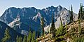
Northwest aspect beyond the forested ridge
|
|
| Highest point | |
| Elevation | 7,750 ft (2,360 m) |
| Prominence | 790 ft (240 m) |
| Isolation | 2.43 mi (3.91 km) |
| Parent peak | Mother Lode (7,905 ft) |
| Geography | |

Hock Mountain
Location in Washington (state)

Hock Mountain
Location in the United States
|
|
| Location | Chelan County / Okanogan County Washington, United States |
| Parent range | North Cascades |
| Topo map | USGS McAlester Mountain |
| Climbing | |
| Easiest route | scrambling |
Hock Mountain is a tall peak in Washington state, reaching 7,750 feet (2,362 meters) high. It's part of the Methow Mountains, which are a smaller group within the larger North Cascades.
This mountain sits right where three important areas meet: North Cascades National Park, Lake Chelan-Sawtooth Wilderness, and Lake Chelan National Recreation Area. It also marks the border between Chelan County and Okanogan County. Hock Mountain is about 2.24 miles south of Stiletto Peak, which is an even taller mountain nearby.
The north side of Hock Mountain has steep, rocky cliffs. But the west side is gentler, making it possible to climb without special gear, just by scrambling. Rain and snow melting on the north and west sides of Hock Mountain flow into the Stehekin River. Water from the south and east sides goes into the South Fork Twisp River.
Mountain Weather and Climate
Most weather comes from the Pacific Ocean and moves east towards the Cascade Mountains. When weather fronts hit the tall North Cascades, they are pushed up. This causes them to drop their moisture as rain or snow onto the mountains.
Because of this, the west side of the North Cascades gets a lot of rain and snow, especially in winter. During winter, it's often cloudy. But in summer, high pressure systems over the Pacific Ocean bring clear skies. The snow here tends to be wet and heavy. This can create a danger of avalanches.
How the Mountains Formed
The North Cascades have some of the roughest land in the Cascade Range. You can see jagged peaks, sharp ridges, and deep valleys carved by glaciers. These amazing landscapes were created by geological events that happened millions of years ago. These events also caused big changes in height, which led to different climates and types of plants in the area.
The Cascade Mountains started forming millions of years ago, during the late Eocene Epoch. At that time, the North American Plate was slowly moving over the Pacific Plate. This movement caused many volcanic eruptions. Also, small pieces of the Earth's crust, called terranes, joined together to form the North Cascades about 50 million years ago.
Over two million years ago, during the Pleistocene period, glaciers repeatedly moved across the land. They scraped away rock and left behind debris. The U-shaped valleys you see today were formed by these glaciers. The combination of land being pushed up (uplift) and cracks in the Earth (faulting), along with glaciation, created the tall peaks and deep valleys of the North Cascades.
Images for kids
-
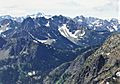
Northeast aspect seen from Kangaroo Ridge
-
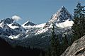
The end of Hock's east ridge (right)
-
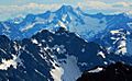
Hock (front) and Bonanza Peak (back) seen from Wallaby Peak
-