
Big Kangaroo facts for kids
Quick facts for kids Big Kangaroo |
|
|---|---|

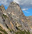
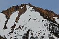
Big Kangaroo seen from Wallaby Peak
|
|
| Highest point | |
| Elevation | 8,280 ft (2,520 m) |
| Prominence | 1,000 ft (300 m) |
| Geography | |

Big Kangaroo
Location in Washington (state)
|
|
| Location | Okanogan County, Washington |
| Parent range | Cascade Range |
| Topo map | USGS Silver Star Mountain |
| Geology | |
| Age of rock | 45 million years old |
| Type of rock | (Rapakivi texture) granite |
| Climbing | |
| First ascent | brothers Helmy and Fred Beckey, Walt Varney, June 21, 1942 |
Big Kangaroo is a tall mountain in Okanogan County, Washington. It stands about 8,280 feet (2,524 meters) high. This mountain is made of a type of rock called granite. Big Kangaroo is part of the Methow Mountains, which are in the Cascade Range. It is the highest point on Kangaroo Ridge. This ridge is about two miles east of Washington Pass and can be seen from there. The closest taller peak is Snagtooth Ridge, which is about 1.7 miles (2.7 km) to the northeast. Rain and melting snow from Big Kangaroo flow into Early Winters Creek. This creek then joins the Methow River.
Contents
Understanding the Climate Around Big Kangaroo
Big Kangaroo is in a "marine west coast" climate zone. This means it gets a lot of weather from the Pacific Ocean. Most weather systems travel northeast towards the Cascade Range. When these systems hit the tall Cascade Mountains, they are forced to rise. This causes them to drop their moisture as rain or snow.
Winter Weather in the Cascades
The western side of the North Cascades gets a lot of rain and snow. This is especially true during the winter months. Winters are usually cloudy here. However, during summer, high-pressure systems over the Pacific Ocean often bring clear skies. The snow in this area tends to be wet and heavy. This can create a high risk of avalanches.
How Big Kangaroo Was Formed
The North Cascades have very rugged land. You can see jagged peaks, long ridges, and deep valleys carved by glaciers. These amazing shapes were created by geological events over millions of years. These events also caused big changes in elevation. This led to different climates and types of plants in the area.
The Ancient History of the Mountains
The Cascade Mountains began forming millions of years ago. This was during a time called the late Eocene Epoch. The North American Plate slowly moved over the Pacific Plate. This caused many volcanic eruptions. Also, small pieces of the Earth's crust, called terranes, helped build the North Cascades. This happened about 50 million years ago.
Ice and Earthquakes Shaping the Land
During the Pleistocene period, which was over two million years ago, glaciers moved across the land many times. As they moved, they scraped away rock and left behind debris. The river valleys in this area have a "U" shape. This shape was created by these recent glaciers. The rising of the land and earthquakes, combined with glaciation, have created the tall peaks and deep valleys we see today.
Images for kids
-

Washington Pass view of Kangaroo Ridge
-
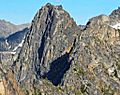
Kangaroo Temple
-
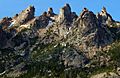
The Fin and The Tomahawk
-
Melted Tower
-
Joey (left) and Big Kangaroo
-
"Joey" 8183'
-
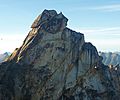
Summit of Big Kangaroo
-
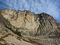
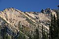
Big Kangaroo's south face
-
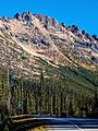
Big Kangaroo viewed from Washington Pass


