
Half Moon (Washington) facts for kids
Quick facts for kids Half Moon |
|
|---|---|

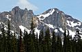
Half Moon, west aspect
|
|
| Highest point | |
| Elevation | 7,960 ft (2,430 m) |
| Prominence | 200 ft (61 m) |
| Geography | |

Half Moon
Location in Washington (state)

Half Moon
Location in the United States
|
|
| Location | Okanogan County, Washington |
| Parent range | Cascade Range |
| Topo map | USGS Silver Star Mountain |
| Geology | |
| Age of rock | 45 million years old |
| Type of rock | (Rapakivi texture) granite |
| Climbing | |
| First ascent | brothers Helmy and Fred Beckey, Walt Varney, June 17, 1942 |
| Easiest route | Climbing class 5+ |
Half Moon is a mountain peak in Okanogan County, Washington state. It stands tall at 7,960+ ft (2,430+ m) (about 2,426 meters). This mountain is part of the Methow Mountains, which are a smaller group within the larger Cascade Range.
Half Moon is located on a place called Kangaroo Ridge. You can see it from the North Cascades Highway at Washington Pass, about two miles away. Its closest taller neighbor is Wallaby Peak, which is only about 0.23 miles (0.37 km) to the south. Rain and melting snow from Half Moon flow into nearby creeks like Early Winters Creek and Cedar Creek. These creeks then join the Methow River.
How Half Moon Was Formed: Geology
The North Cascades area has very rugged land. It features sharp peaks, long ridges, and deep valleys carved by glaciers. Many millions of years ago, huge geological events shaped this land. These events created the different heights and landforms you see today. This also led to various climate differences across the Cascade Range. These climate changes affect the types of plants and animals that live in different areas.

The story of how the Cascade Mountains formed began millions of years ago. This was during the late Eocene Epoch. The North American Plate (a huge piece of Earth's crust) slowly moved over the Pacific Plate. This movement caused volcanoes to erupt and create new rock. Also, small pieces of the Earth's crust, called terranes, joined together. This helped form the North Cascades about 50 million years ago. Half Moon is made of granite, just like many other peaks near Washington Pass. This granite formed deep underground and was later pushed up.
During the Pleistocene period, which was over two million years ago, glaciers covered and uncovered the land many times. As these huge ice sheets moved, they scraped away rock and left behind rocky debris. The valleys of the rivers in this area have a "U" shape. This shape was carved by these ancient glaciers. The land being pushed up (uplift) and cracks in the Earth's crust (faulting), along with glaciers, have created the tall peaks and deep valleys of the North Cascades.
Weather Around Half Moon: Climate
Most weather systems begin over the Pacific Ocean. They then travel northeast towards the Cascade Mountains. As these weather systems reach the North Cascades, the tall peaks force the air to rise. This process is called Orographic lift. When the air rises, it cools down and drops its moisture. This moisture falls as rain or snowfall onto the Cascades.
Because of this, the western side of the North Cascades gets a lot of rain and snow. This is especially true during the winter months. In winter, the weather is often cloudy. However, during the summer, high-pressure systems over the Pacific Ocean become stronger. This often means there are very few clouds, and the weather is sunny. The snow in this area tends to be wet and heavy because of the ocean's influence. This can sometimes lead to a danger of avalanches.
Images for kids
-
Half Moon (left) and Wallaby Peak

