Hudson (CDP), Massachusetts facts for kids
Quick facts for kids
Hudson, Massachusetts
|
|
|---|---|

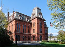
Hudson Town Hall
|
|

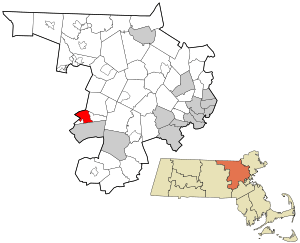
Location in Middlesex County in Massachusetts
|
|
| Country | United States |
| State | Massachusetts |
| County | Middlesex |
| Town | Hudson |
| Area | |
| • Total | 5.92 sq mi (15.33 km2) |
| • Land | 5.75 sq mi (14.88 km2) |
| • Water | 0.17 sq mi (0.45 km2) |
| Elevation | 217 ft (66 m) |
| Population
(2020)
|
|
| • Total | 15,749 |
| • Density | 2,741.34/sq mi (1,058.42/km2) |
| Time zone | UTC-5 (Eastern (EST)) |
| • Summer (DST) | UTC-4 (EDT) |
| ZIP code |
01749
|
| Area code(s) | 978 |
| FIPS code | 25-31575 |
| GNIS feature ID | 0611243 |
Hudson is a special kind of area called a census-designated place (CDP). It includes the main, busy part of the town of Hudson in Middlesex County, Massachusetts, United States. In 2020, about 15,749 people lived in this CDP. The whole town of Hudson had a population of 20,092 people.
Contents
Geography of Hudson
Hudson CDP is located on the western side of Middlesex County. You can find it at coordinates 42°23′32″N 71°33′56″W / 42.39222°N 71.56556°W. It sits in the west-central part of the larger town of Hudson.
Borders and Nearby Towns
Hudson CDP shares its southern border with the city of Marlborough. To the northeast, it borders the town of Stow. On its northwest and west sides, you'll find the towns of Bolton and Berlin. These two towns are in a different county called Worcester County.
Inside the town of Hudson, the CDP is marked by certain roads and natural features. To the east, it's bordered by Zina Road, Cox Street, Forest Avenue, Old North Road, and Causeway Street. To the southwest, it's bordered by Chapin Road, Brigham Street, Washington Street, and the Assabet River Rail Trail.
Main Roads and Rivers
Several important roads run through Hudson. Massachusetts Route 62 goes through the community as Central Street and Main Street. If you follow Route 62 northeast, it's about 5 miles (8 km) to the center of Stow. Going west, it's about 4 miles (6 km) to the center of Berlin.
Massachusetts Route 85 also passes through Hudson as Washington Street and Lincoln Street. Heading north on Route 85, it's about 3 miles (5 km) to Route 117 in Bolton. If you go southwest, it's about 3.5 miles (5.6 km) to the center of Marlborough. There's also Route 85C, which turns southwest from Route 85. It leads about 1.5 miles (2.4 km) to a major highway interchange where I-495 and I-290 meet.
Land and Water Features
The Hudson CDP covers a total area of about 5.92 square miles (15.33 km²). Most of this area, about 5.75 square miles (14.88 km²), is land. The rest, about 0.18 square miles (0.45 km²), is water. This means about 2.96% of the CDP is water.
The Assabet River flows right through the middle of the CDP. It moves northeastward and eventually joins the Concord River in Concord. The water from the Assabet River eventually flows into the Merrimack River, making Hudson part of the Merrimack River's watershed.
People of Hudson (Demographics)
| Historical population | |||
|---|---|---|---|
| Census | Pop. | %± | |
| 1960 | 7,897 | — | |
| 1970 | 14,283 | 80.9% | |
| 1980 | 14,156 | −0.9% | |
| 1990 | 14,267 | 0.8% | |
| 2000 | 14,388 | 0.8% | |
| 2010 | 14,907 | 3.6% | |
| 2020 | 15,749 | 5.6% | |
| U.S. Decennial Census | |||
In the year 2000, there were 14,388 people living in the Hudson CDP. These people lived in 5,652 households, and 3,809 of these were families. The population density was about 971 people per square kilometer (2,515 people per square mile). This means a lot of people live close together in this area.
Who Lives Here?
Most people in Hudson CDP in 2000 were White (about 93.91%). There were also smaller groups of African American (0.88%), Native American (0.15%), and Asian (1.22%) residents. About 1.64% of the population identified as other races, and 2.18% were from two or more races. About 3.48% of the population identified as Hispanic or Latino.
Households and Families
Out of all the households, about 30.4% had children under 18 living there. More than half (54.2%) were married couples living together. About 9.7% of households had a female head with no husband present. And 32.6% were not families, meaning they were single people or unrelated roommates.
About 27.1% of all households were made up of just one person. And 10.6% of these were people aged 65 or older living alone. On average, there were 2.52 people in each household and 3.10 people in each family.
Age and Income
The population in Hudson CDP was spread out by age. About 23.2% were under 18 years old. About 7.0% were between 18 and 24. The largest group, 33.5%, was between 25 and 44 years old. About 23.2% were between 45 and 64, and 13.1% were 65 years or older. The average age was 37 years.
The median income for a household in the CDP was $55,063. For families, the median income was higher at $67,643. The per capita income (income per person) for the CDP was $25,167. About 5.3% of all people, and 3.3% of families, lived below the poverty line. This included 4.0% of those under 18 and 10.5% of those 65 or older.
See also
 In Spanish: Hudson (condado de Middlesex) para niños
 | Delilah Pierce |
 | Gordon Parks |
 | Augusta Savage |
 | Charles Ethan Porter |

