
Huechulafquen Lake facts for kids
Quick facts for kids Huechulafquen Lake |
|
|---|---|
 |
|

Huechulafquen Lake
Location in Argentina
|
|
| Location | Huiliches Department, Neuquén Province, Argentina, in Patagonia |
| Coordinates | 39°46′12″S 71°22′48″W / 39.77000°S 71.38000°W |
| Type | glacial |
| Primary outflows | Chimehuin River |
| Basin countries | Argentina |
| Max. length | 30 km (19 mi) |
| Max. width | 5 km (3.1 mi) |
| Surface area | 78.2 square kilometres (19,300 acres) |
| Average depth | 142 metres (466 ft) |
| Water volume | 11.1 cubic kilometres (9,000,000 acre⋅ft) |
| Residence time | 4.96 years |
| Surface elevation | 875 metres (2,871 ft) |
Huechulafquen Lake (say "way-choo-LAHF-ken") is a big, beautiful lake in Argentina, located in a region called Patagonia. It's a glacial lake, which means it was formed by huge, slow-moving rivers of ice called glaciers. You can find it high up in the Andean mountains, inside Lanín National Park. It's about 25 kilometers from Junín de los Andes and 60 kilometers from San Martín de los Andes. This lake is one of the biggest in the Argentine Andes and gets its water from melting glaciers and streams.
Contents
What Makes Huechulafquen Lake Special?
The name of the lake comes from the Mapuche language and means long lake. This is a perfect name because the lake is about 30 kilometers (19 miles) long and 5 kilometers (3 miles) wide. Its total surface area is about 78.2 square kilometers (30.2 square miles).
Connected Lakes: Paimún and Epulafquén
Two smaller lakes, Paimún and Epulafquén, are connected to Huechulafquen Lake. They are linked by short, narrow, and shallow channels. Even though they are connected, people usually think of them as separate lakes. If they were counted as one, the total size would be about 30 square kilometers (7,400 acres) larger. The Chimehuin River flows out of Huechulafquen Lake towards the southeast, eventually reaching the Atlantic Ocean. The closest city to the lake is Junin de los Andes.
Lake Paimún and Lanín Volcano
Lake Paimún is the northern part of Huechulafquen Lake and is about 11 kilometers (7 miles) long. The mighty Lanin volcano, which is 3,740 meters (12,270 feet) tall, stands tall over its northern shore. Lake Paimún gets its water from glaciers on Lanín volcano and from small streams that start near the border with Chile.
Lake Epulafquén and Volcanic Activity
Lake Epulafquén is the southern part of the lake and is about 7 kilometers (4 miles) long. A group of volcanoes called the Huanquihue Group, which reach 2,139 meters (7,018 feet) high, rise above its southern shore. Around the year 1800, lava from one of these volcanoes flowed all the way to the lake's southern shore. This created a rocky and uneven area.
A short, fast-moving stream brings water from two other lakes, Lake Curruhué (12 kilometers or 7 miles long) and Green Lake (1 kilometer or 0.6 miles long), into Lake Epulafquén. Another small stream flows into Lake Epulafquén from Lake Carilafquén, which is about 1 kilometer (0.6 miles) long. You can also find hot springs and places for thermal baths near the shores of Lake Epulafquén.
Weather Around the Lake
Huechulafquen Lake runs from east to west. This means the weather changes a lot along its shores. In the higher mountains overlooking the lake, there's a lot of rain, about 4,000 millimeters (157 inches) each year. But at the eastern end of the lake, the rainfall drops to about 1,400 millimeters (55 inches) per year. Most of this rain falls during the winter in the Southern Hemisphere.

Fun Things to Do at the Lake
Huechulafquen Lake is a popular place for visitors! You can enjoy many outdoor activities here, like camping, hiking, and boating. If you're feeling adventurous, you can even try climbing Lanín volcano.
The lake is also famous for fishing. People come here to catch rainbow trout and brown trout. These types of fish were brought to Argentina in the early 1900s.
A road runs along the north shore of the lake. Along this road, you'll find several communities of the Mapuche people, who live inside Lanín National Park. Another road touches the southern shore of Lake Epulafquén, giving you access to the areas where the volcanic lava flowed. This road continues west and crosses into Chile at the Carirriñe Pass, which is 1,223 meters (4,012 feet) high.
Images for kids
-
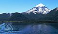
Lanin volcano looks over the northern shore of Lake Paimún, which is part of Lake Huechulafquen.
-
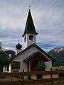
The Maria Auxiladora chapel on Lake Paimún.


See also
 In Spanish: Lago Huechulafquen para niños
