Humboldt Lagoons State Park facts for kids
Quick facts for kids Humboldt Lagoons State Park |
|
|---|---|

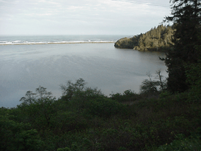
Stone Lagoon and coastal bar viewed from Highway 101
|
|
| Location | Humboldt County, California, USA |
| Nearest city | Trinidad, California |
| Area | 2,256 acres (9.13 km2) |
| Established | 1931 |
| Governing body | California Department of Parks and Recreation |
Humboldt Lagoons State Park is a special place on the California coast. It sits right next to the Pacific Ocean in Humboldt County, in northwestern California. This state park helps protect three amazing lagoons. These lagoons are home to important estuaries and wetlands. You can find the park off U.S. Route 101, between the city of Eureka and the Oregon border.
Contents
Discovering Humboldt Lagoons State Park
Humboldt Lagoons State Park covers about 2,256 acres. It was created in 1931 to protect these unique coastal areas. The park is famous for its three main lagoons.
What are the Lagoons Like?
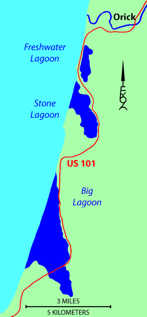
The three lagoons are Big Lagoon, Stone Lagoon, and Freshwater Lagoon.
- Big Lagoon is the biggest and is located farthest south.
- Stone Lagoon is in the middle.
- Freshwater Lagoon is the smallest and is the most northern.
These lagoons are like shallow bays. They are found between rocky parts of the coast called headlands. The strong ocean waves have built up sandy bars. These sand bars act like natural walls, separating each lagoon from the open ocean.
Home for Migratory Birds
The lagoons are very important resting spots for many water birds. These birds are on a long journey called the Pacific Flyway. This is a major route that birds use to fly between their breeding grounds and their winter homes.
The lagoons in the park are like a hotel for birds. They stop here between Lake Earl to the north and Humboldt Bay to the south. Lake Earl is about 40 miles (64 km) away, and Humboldt Bay is about 30 miles (48 km) away.
How the Lagoons Change Over Time
The land around Humboldt Bay has changed a lot over many centuries. This is due to tectonic activity. This means the Earth's crust is slowly moving. These movements can cause the sea level to rise or fall in the area.
When the land rises, the shallow lagoons might become freshwater wetlands. They could even turn into forests with tall Sitka spruce trees. But when the land sinks, the lagoons might become salt marshes. They could also become underwater beds where shellfish live.
The Story of Dry Lagoon
Dry Lagoon is located at the southern end of Stone Lagoon. A piece of land separates it from Stone Lagoon. If the sea level keeps rising, this piece of land might even become an island!
Today, Dry Lagoon is a wetland. It shows us how other similar areas might have looked naturally. Some of these areas were used for sawmills near Big Lagoon. Others were turned into farms around the estuaries of Redwood Creek to the north and Little River to the south.
 | Selma Burke |
 | Pauline Powell Burns |
 | Frederick J. Brown |
 | Robert Blackburn |


