
Redwood Creek (Humboldt County) facts for kids
Quick facts for kids Redwood Creek |
|
|---|---|

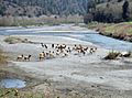
Redwood Creek seen with a herd of Roosevelt Elk on its banks
|
|

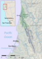
Map of Redwood Creek basin
|
|
| Country | United States |
| State | California |
| Region | Humboldt County |
| City | Orick |
| Physical characteristics | |
| Main source | Board Camp Mountain Redwood National Park 4,400 ft (1,300 m) 40°42′21″N 123°42′14″W / 40.70583°N 123.70389°W |
| River mouth | Pacific Ocean Orick 0 ft (0 m) 41°17′32″N 124°05′31″W / 41.29222°N 124.09194°W |
| Length | 61.8 mi (99.5 km), South-north |
| Basin features | |
| Basin size | 279 sq mi (720 km2) |
| Tributaries |
|
Redwood Creek is a river in Humboldt County, California. It is about 61.8 miles (99.5 km) long. The river starts high up in the California Coast Ranges mountains. It flows mostly northwest until it reaches the Pacific Ocean. This happens near the small town of Orick. Orick is the only town in the river's large watershed, which covers about 280 square miles (725 km²). The local Yurok people call the river 'O'rekw 'We-Roy .
Contents
Where Does Redwood Creek Flow?
Redwood Creek begins near Board Camp Mountain. This area is in the Coast Ranges, close to a place called Dinsmores. The very start of the stream is about 4,400 feet (1,341 meters) above sea level. It flows north through a deep valley filled with trees. Many smaller streams join it along the way. These include Minor and Lacks creeks. About 15 miles (24 km) downstream, the creek goes under State Route 299.
Journey Through Redwood National Park
The river enters Redwood National Park about 20 miles (32 km) before it reaches the ocean. Here, another creek called Bridge Creek joins it. The river then winds through amazing groves of Sequoia sempervirens. These are giant redwood trees, and the river gets its name from them. Some of the tallest redwood trees in the world grow right by the creek's banks. Near the town of Orick, the creek turns west. Its biggest side stream, Prairie Creek, flows into it here. Finally, Redwood Creek empties into the Pacific Ocean. This spot is about 30 miles (48 km) north of Eureka. It is also about 27 miles (43 km) south of Crescent City.
Understanding the Redwood Creek Watershed
A watershed is an area of land where all the water drains into one main river or stream. The Redwood Creek watershed is long and narrow. It covers about 280 square miles (725 km²) in Humboldt County. It stretches for about 35 miles (56 km) from north to south. Its width ranges from about 4.5 to 7 miles (7 to 11 km). Most of the river flows through a wide valley. This valley is about 1,500 feet (457 meters) deep. It sits between the Mad River basin to the west and the Klamath River area to the east.
What is the Land Used For?
The land around Redwood Creek is used for different things. The river itself is a great place for fun activities like fishing. It also provides water for farms and businesses in Orick, California. The lower part of the creek and its estuary (where the river meets the sea) are part of Redwood National and State Parks. However, most of the upper part of the creek is owned by private groups. The park owns 41% of the watershed. Other government groups own 3%. Private landowners own 55% of the land upstream. Since the 1800s, many trees in the watershed have been cut down. This is called logging. Some areas were completely cleared of trees, even as recently as the 1970s. This happened when logging companies cut down as many trees as possible. They did this before Redwood National Park grew larger.
Wildlife and River Health

Redwood Creek is home to many animals. It provides important habitat for fish that need cold, fresh water. These fish use the creek to migrate and lay their eggs. One big problem for the creek is erosion. This is when soil and rock are washed away. Erosion causes too much sediment (dirt and sand) to build up in the riverbed. This extra sediment comes from a lot of logging in the upper parts of the watershed. Logging has been the main use of the land since the 1950s.
How Logging Affects the River
In the last 20 years, 65% of all land in the basin has been used for cutting trees. About 75% of the forested land has been harvested for timber. Building roads for logging trucks also makes erosion worse. The sediment fills up the deep pools and spawning areas. These are places where fish like steelhead and coho salmon lay their eggs. This has caused a big drop in the number of fish.
Changes to the Creek's Flow
The lower part of the creek has also been damaged. This happened after big floods in 1955 and 1964. The United States Army Corps of Engineers changed the last 3.4 miles (5.5 km) of the creek. They did this by dredging (digging out the bottom) and building levees (walls to hold back water). These changes made the creek flow differently. They also changed how sediment settled. This resulted in less water flowing in the creek. It also destroyed the plants along the riverbanks. These plants, called riparian vegetation, help stop erosion. They also keep the water cool. Cool water is important for the creek's coldwater fish.
Images for kids
-
Redwood Creek with Roosevelt Elk
-
Map of Redwood Creek basin
