Hurricane, West Virginia facts for kids
Quick facts for kids
Hurricane, West Virginia
|
||
|---|---|---|

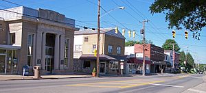
Main Street in Hurricane in 2007
|
||
|
||

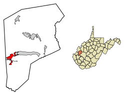
Location of Hurricane in Putnam County, West Virginia.
|
||
| Country | United States | |
| State | West Virginia | |
| County | Putnam | |
| Government | ||
| • Type | Mayor-Council | |
| Area | ||
| • Total | 3.78 sq mi (9.78 km2) | |
| • Land | 3.74 sq mi (9.70 km2) | |
| • Water | 0.03 sq mi (0.08 km2) | |
| Elevation | 705 ft (215 m) | |
| Population
(2020)
|
||
| • Total | 6,977 | |
| • Estimate
(2021)
|
6,919 | |
| • Density | 1,717.41/sq mi (663.15/km2) | |
| Time zone | UTC-5 (Eastern (EST)) | |
| • Summer (DST) | UTC-4 (EDT) | |
| ZIP code |
25526
|
|
| Area code(s) | 304, 681 | |
| FIPS code | 54-39532 | |
| GNIS feature ID | 1554759 | |
| Website | http://www.hurricanewv.com/ | |
Hurricane is a city in Putnam County, West Virginia, United States. The city had a population of 6,977 people in 2020. Hurricane is located between the larger cities of Charleston and Huntington. It is part of the Huntington–Ashland metropolitan area.
Contents
Discovering Hurricane's Past
Hurricane got its name from Hurricane Creek. The creek was named after a group of trees that were bent in one direction. This looked like they had been hit by a hurricane. Surveyors working for George Washington noticed this unusual sight. Locals say the town's name as "HURR-i-KINN."
Early Settlements and the Civil War
An older town called Hurricane Bridge existed where West Virginia Route 34 now crosses the creek. This town appeared on a Virginia map in 1811. It mainly had a large inn. During the American Civil War, a battle took place here. On March 28, 1863, Union and Confederate soldiers fought at Hurricane Bridge. This event is now known as the Battle of Hurricane Bridge.
How Hurricane Grew as a Town
The city of Hurricane itself began to develop around 1873. This was when a railroad track was built through the area. A small train station, or depot, was also constructed. This led to the growth of Main Street and other businesses. In the early 1900s, Hurricane was a center for trade and living for tobacco growers and other farmers. The local fire department was started on March 2, 1936. Hurricane became an official town in 1889 and a city in the 1970s.
Long-Standing Businesses in Hurricane
Some businesses in Hurricane have been open for a very long time. The three oldest ones that are still running today are:
- The Hurricane Breeze, a weekly newspaper that started in October 1900.
- Putnam County Bank, which opened on October 25, 1901.
- Rappold's Barber Shop, established in June 1906.
Modern Growth and Changes
In the early 1990s, the old train depot was taken down. A small gazebo was built in its place. Also during the 1990s, Hurricane saw a lot of new growth. Many new neighborhoods were built within the city limits. This increase in people led to bigger roads, like Route 34. It also led to an expansion of Hurricane High School.
Understanding Hurricane's Geography
Hurricane is located at 38°25′57″N 82°1′11″W / 38.43250°N 82.01972°W. This means it is in a specific spot on the Earth.
According to the United States Census Bureau, the city covers about 3.77 square miles (9.77 square kilometers). Most of this area, about 3.74 square miles (9.70 square kilometers), is land. A small part, about 0.03 square miles (0.08 square kilometers), is water.
Population Facts About Hurricane
| Historical population | |||
|---|---|---|---|
| Census | Pop. | %± | |
| 1880 | 67 | — | |
| 1890 | 207 | 209.0% | |
| 1900 | 240 | 15.9% | |
| 1910 | 422 | 75.8% | |
| 1920 | 666 | 57.8% | |
| 1930 | 1,293 | 94.1% | |
| 1940 | 1,103 | −14.7% | |
| 1950 | 1,463 | 32.6% | |
| 1960 | 1,970 | 34.7% | |
| 1970 | 3,491 | 77.2% | |
| 1980 | 3,751 | 7.4% | |
| 1990 | 4,461 | 18.9% | |
| 2000 | 5,222 | 17.1% | |
| 2010 | 6,284 | 20.3% | |
| 2020 | 6,977 | 11.0% | |
| 2021 (est.) | 6,919 | 10.1% | |
| Source: | |||
Hurricane's Population in 2010
In 2010, the city of Hurricane had 6,284 people living there. There were 2,499 households, which are groups of people living together. About 1,785 of these were families. The city had about 1,680 people per square mile.
Most of the people in Hurricane were White (96.7%). A smaller number were African American (1.0%), Native American (0.2%), or Asian (0.7%). Some people were from other races or a mix of two or more races. About 0.9% of the population was Hispanic or Latino.
About 35.2% of households had children under 18 living with them. More than half (55.0%) were married couples. The average household had 2.51 people. The average family had 3.00 people. The median age in the city was 38.1 years old. This means half the people were younger and half were older than 38.1. About 25.5% of residents were under 18.
The Harrah Organ: A Musical Treasure
Hurricane is home to a very large and special musical instrument. It is a six-manual hybrid pipe organ located at the Forrest Burdette Memorial United Methodist Church. This organ combines traditional pipes with digital sounds. It has 456 stops, which control the different sounds it can make.
The organ was built by Allen Harrah and was first played on September 28, 2003. The church often hosts concerts featuring famous organ players from across the U.S. and Canada. These concerts are a special event for the community.
Famous People from Hurricane
Hurricane has been home to several notable individuals. These people have achieved recognition in different fields:
- John "Doc" Holliday, a former head football coach at Marshall University.
- Lauren Oyler, a well-known author and critic.
- Tyler Payne, a professional baseball player who played for the Chicago Cubs.
- Alex Wilson, a relief pitcher in Major League Baseball for the Boston Red Sox.
See also
 In Spanish: Hurricane (Virginia Occidental) para niños
 | Jackie Robinson |
 | Jack Johnson |
 | Althea Gibson |
 | Arthur Ashe |
 | Muhammad Ali |


