
Hurricane Jose (2017) facts for kids
Hurricane Jose was a powerful storm that formed in the Atlantic Ocean in 2017. It was a tropical cyclone, which is a big storm system that spins around a center of low pressure. Jose brought strong winds and heavy rain to several places.
The storm first threatened the Leeward Islands, which are a group of islands in the Caribbean Sea. These were the same islands that had just been hit by another very strong storm called Hurricane Irma.
Jose's winds were very fast, reaching up to 155 miles per hour. This happened before it got close to the Leeward Islands. Later, Jose moved north and threatened parts of the United States.
Contents
What Was Hurricane Jose?
Hurricane Jose was a major Atlantic hurricane in 2017. It was one of several strong storms that formed that year. Hurricanes are huge storms that get their energy from warm ocean waters. They bring very strong winds, heavy rain, and can cause big waves and flooding.
Jose was known for its powerful winds. At its strongest, it was a Category 4 hurricane. This means its winds were between 130 and 156 miles per hour. Such strong winds can cause a lot of damage to buildings and trees.
Jose's Path and Impact
Hurricane Jose traveled a long way across the Atlantic Ocean. Its journey began far out at sea. It first moved towards the Leeward Islands. These islands include places like Antigua and Barbuda and Saint Martin. People there had to prepare for the storm, even though they had just dealt with Hurricane Irma.
After passing the Leeward Islands, Jose turned north. It then moved closer to the East Coast of the United States. On September 17, 2017, weather experts issued warnings for many areas. These warnings were for places from the border of Maryland and Delaware all the way up to eastern Massachusetts.
States Threatened by Jose
Even though Jose did not make a direct landfall in the United States, it still caused concerns. The storm brought strong winds and rough seas to coastal areas. Many states had to prepare for its effects.
The states that were threatened included:
People in these areas were told to be ready for possible flooding and power outages. The U.S. Geological Survey even put special sensors in some states. These sensors helped measure how high the water rose because of the storm.
Images for kids
-
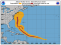
Tropical Storm Jose off the United States East Coast on September 19
-
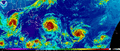
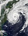
Jose (right) strengthening while threatening the Leeward Islands during the first occurrence of three active Atlantic hurricanes since 2010. Hurricanes Irma and Katia can be seen to the left of Jose.
-
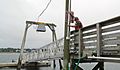
U.S. Geological Survey specialists installed 17 storm-tide sensors in Connecticut, Massachusetts, and Rhode Island.
-
Hurricane Jose's wind history.


See also
 In Spanish: Huracán José (2017) para niños
