Ice Box (Washington) facts for kids
Quick facts for kids Ice Box |
|
|---|---|

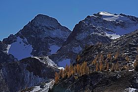
Ice Box (summit left) from Upper Ice Lake
|
|
| Highest point | |
| Elevation | 8,112 ft (2,473 m) |
| Prominence | 472 ft (144 m) |
| Isolation | 1.51 mi (2.43 km) |
| Parent peak | Mount Maude (9040+ ft) |
| Geography | |
| Location | Chelan County Washington, U.S. |
| Parent range | Entiat Mountains North Cascades |
| Topo map | USGS Trinity |
| Climbing | |
| Easiest route | class 3 |
Ice Box is a mountain peak in Washington state. It stands tall at 8,112-foot (2,473-metre) (about 2,473 meters) above sea level. You can find Ice Box in Chelan County, within the Entiat Mountains. These mountains are part of the larger North Cascades range.
Ice Box is quite a notable peak. It ranks as the ninth-highest mountain in the Entiat Mountains. It's also among the top 150 highest peaks in all of Washington state. Its name comes from its location between two creeks: Ice Creek and Box Creek.
Contents
Exploring the Climate Around Ice Box Mountain
The area around Ice Box mountain has a special climate. It sits east of the Cascade Mountains, which means it's a bit drier than places to the west.
Weather Patterns and Seasons
Summers near Ice Box can be warm. Sometimes, you might even see thunderstorms. Most of the weather in this region comes from the Pacific Ocean. These weather systems usually travel northeast towards the Cascade Mountains.
As these weather systems hit the tall peaks of the North Cascades, they are forced to rise. This process is called Orographic lift. When the air rises, it cools down and drops its moisture. This moisture falls as rain or snow onto the Cascades.
Snowfall and Temperatures
Because of this effect, the North Cascades get a lot of rain and especially heavy snowfall. This is most true during the winter months. With its impressive height, Ice Box mountain can have snow on its slopes in late spring and early fall. Winters on the mountain can be very cold.
Discovering the Geology of Ice Box Mountain
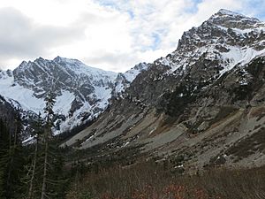
The North Cascades are known for their very rugged landscape. You'll see sharp, craggy peaks, long ridges, and deep valleys carved by glaciers. These amazing features were created by geological events that happened millions of years ago. These events led to big changes in the land's height and shape.
How the Mountains Were Formed
The story of the Cascade Mountains began millions of years ago, during the late Eocene Epoch. At that time, the North American Plate was slowly moving over the Pacific Plate. This movement caused many volcanic eruptions over a long period.
One important volcano nearby is Glacier Peak. It's a stratovolcano located about 14.7 mi (23.7 km) west of Ice Box. Glacier Peak started forming in the middle of the Pleistocene period. Because Glacier Peak is so close to Ice Box, you can often find volcanic ash and tephra (small bits of rock and ash from eruptions) in the area.
The Impact of Glaciers
During the Pleistocene period, which started over two million years ago, glaciers played a huge role. These massive ice sheets moved forward and backward many times. As they moved, they scraped and shaped the land, leaving behind piles of rock debris.
The "U"-shaped valleys you see in the rivers today are a direct result of these recent glaciers. The combination of land being pushed up (called uplift) and cracks forming in the Earth's crust (called faulting), along with the action of glaciers, created the tall peaks and deep valleys of the North Cascades area.
 | Victor J. Glover |
 | Yvonne Cagle |
 | Jeanette Epps |
 | Bernard A. Harris Jr. |


