Illawong facts for kids
Quick facts for kids IllawongSydney, New South Wales |
|||||||||||||||
|---|---|---|---|---|---|---|---|---|---|---|---|---|---|---|---|

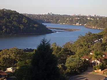
Illawong, view of Georges River
|
|||||||||||||||
| Population | 7,271 (2016 census) | ||||||||||||||
| Postcode(s) | 2234 | ||||||||||||||
| Elevation | 99 m (325 ft) | ||||||||||||||
| Location | 27 km (17 mi) south-west of Sydney CBD | ||||||||||||||
| LGA(s) | Sutherland Shire | ||||||||||||||
| State electorate(s) | Miranda | ||||||||||||||
| Federal Division(s) | Hughes | ||||||||||||||
|
|||||||||||||||
Illawong is a suburb located in southern Sydney, New South Wales, Australia. It is about 27 kilometers south of the main city area of Sydney. Illawong is part of the Sutherland Shire local government area. This area is often called Menai. The postcode for Illawong is 2234. This postcode is shared with nearby suburbs like Menai, Bangor, Barden Ridge, and Alfords Point.
Illawong is special because it sits between two rivers. The Georges River is to its south, and the Woronora River is to its north. Illawong is mostly made up of houses. It also has a nursing home, a primary school, and a small shopping center.
Contents
Discovering Illawong's Past
Illawong is an Aboriginal word. It means "between two waters." This name perfectly describes its location between the Georges and Woronora Rivers. Long ago, the Tharawal and/or Eora tribes lived here. They left behind clues about their lives. These clues include shell mounds (middens), rock carvings, and cave paintings.
Early European Exploration
Captain John Hunter was the first European to explore this area. He was a Royal Navy officer. In 1789, Captain Hunter sailed through the Georges and Woronora Rivers. Later, in 1795–96, he explored further. He was with Matthew Flinders and George Bass. They went up the Georges River. Hunter then declared the area of Bankstown.
Building Old Illawarra Road
A very old road called Old Illawarra Road was built between 1843 and 1845. Major Thomas Mitchell, a famous explorer, checked the road. This road was one of the last public works built by convicts. It made the journey to the South Coast about 32 kilometers shorter. Major Mitchell took the road across a shallow part of the Woronora River. He named this spot "Pass of Sabugal."
Illawong as a Holiday Spot
In the 1890s, Menai was mostly a farming area. Illawong, which was then called East Menai, became a popular place. Wealthy people from Sydney built holiday homes here. They came to enjoy their weekends away from the city.
Joining Sutherland Shire
Illawong was originally part of the Hurstville Municipality. But in 1921, it became part of the Sutherland Shire. This change helped shape the area we know today.
How Streets Got Their Names
In the 1970s, the Menai region grew with more houses. Illawong was given street names related to nautical history. This means names linked to ships and the sea. Other nearby suburbs also got special names. For example, Bangor, New South Wales has Aboriginal names. Alfords Point, New South Wales has names of plants. Barden Ridge, New South Wales has names of Australian pioneers.
Facing Bushfires
In 1994, big bushfires hit the eastern coast. Illawong was badly affected by these fires. Other suburbs like Alfords Point, Bangor, Menai, and Como also saw damage. Because of its natural surroundings, Illawong is still considered an area where bushfires can happen.
Who Lives in Illawong?
The 2016 census counted 7,271 people living in Illawong. Most people in Illawong have English or Australian backgrounds. Other common backgrounds include Irish, Scottish, and Lebanese. About 75.7% of residents were born in Australia. The next most common birthplaces were England, Lebanon, and China.
Languages and Beliefs
About 74.4% of people in Illawong speak only English at home. Other languages spoken include Arabic, Greek, Cantonese, Macedonian, and Mandarin. When it comes to religion, the most common choices were Catholic, Anglican, and Eastern Orthodox. About 17.3% of people reported having no religion.
Household Income and Homes
The average weekly income for households in Illawong was $2,466. This amount was much higher than the national average of $1,438. Most homes in Illawong are separate houses. They tend to be quite large. About 72.4% of homes have four or more bedrooms.
Shopping and Services
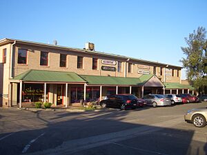
The Illawong Village shopping center is located between Fowler Road and Hobart Place. It started as a small group of shops. In 2007, the shopping center was rebuilt and made bigger. Illawong Village now has a supermarket and a large liquor store. It also has many specialty shops. These include a butcher, a chemist, gift shops, and several cafes and restaurants.
Getting Around Illawong
The main roads in Illawong are Fowler Road and Moreton Road. U-Go Mobility provides regular bus services. These buses connect Illawong to nearby areas. You can travel to places like Menai, Sutherland, and Bankstown by bus.
Local Schools
Illawong has its own primary school:
- Illawong Primary School
- Tharawal Primary School
For older students, Menai High School is the main public high school. It serves both boys and girls from the Menai area.
Places of Worship
The main church in Illawong is the Menai Illawong Uniting Church. It is located close to the Illawong shopping center.
Sports and Fun Activities
Illawong is home to the 1st Wearne Bay Sea Scouts group. This group offers all five youth sections. These sections are Joeys, Cubs, Scouts, Venturers, and Rovers. The group meets at their scout hall in Wearne Bay. This hall is right on the Georges River. The building used to be the home of the old ferry master, Mr. Maurie Chegwidden. The Sea Scout group started in 1966.
Emergency Services
The Menai/Illawong Rural Fire Service (RFS) station is located in Illawong. It is at the roundabout where Old Illawarra Road meets Fowler Road. The RFS helps keep the community safe from bushfires and other emergencies.


