
Inclined Temple facts for kids
Quick facts for kids Inclined Temple |
|
|---|---|

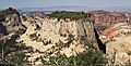
East aspect, from West Rim Trail
|
|
| Highest point | |
| Elevation | 7,150 ft (2,180 m) |
| Prominence | 630 ft (190 m) |
| Isolation | 0.92 mi (1.48 km) |
| Parent peak | Point 7370 (7,370 ft) |
| Geography | |

Inclined Temple
Location in Utah

Inclined Temple
Location in the United States
|
|
| Location | Zion National Park Washington County, Utah United States |
| Parent range | Colorado Plateau |
| Topo map | USGS The Guardian Angels |
| Geology | |
| Age of rock | Jurassic |
| Type of rock | Navajo sandstone |
| Climbing | |
| Easiest route | class 5+ climbing |
Inclined Temple is a tall, remote mountain peak in Zion National Park, located in southwest Utah, United States. It stands about 7,150 feet (2,180 meters) high.
What is Inclined Temple?
Inclined Temple is a special kind of mountain. It looks like a flat-topped hill, which is called a mesa. This mesa is made of a type of rock called Navajo Sandstone.
The mountain is about 7 miles (11 km) north of Springdale, Utah. Its closest neighbor is Ivins Mountain, which is half a mile north. Another peak, South Guardian Angel, is about three miles to the west-northwest.
The name "Inclined Temple" was officially chosen in 1935. It got its name because its wide top has a clear slope or "incline." Water from rain and snow on the mountain flows into North Creek. This creek then joins the Virgin River.
Weather at Inclined Temple
The best times to visit Inclined Temple are during spring and fall. The area has a "cold semi-arid climate." This means winters can be cold, with average temperatures below 32 °F (0 °C).
Even though it can be cold, this is a desert climate. It gets less than 10 inches (254 mm) of rain each year. Snowfall in winter is usually light. Most of the rain happens in spring and summer.
Images for kids
-
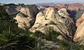
Inclined Temple seen from Zion's West Rim Trail
-
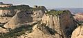
Inclined Temple (left) and Ivins Mountain (right of center) seen from West Rim Trail
-
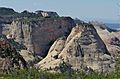
Point 7370 (left), Inclined Temple (right), The Bishopric (two peaks centered in back)
-
Ivins Mountain (right), Inclined Temple (left)


