Inner Seas off the West Coast of Scotland facts for kids
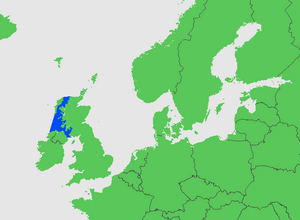
The Inner Seas off the West Coast of Scotland is a special part of the ocean. It's a marine area officially named by a group called the International Hydrographic Organization (IHO). Think of it as the waters found between the mainland of Scotland, the Outer Hebrides islands, and the coast of Ireland.
What are the Inner Seas off Scotland?
The Inner Seas off the West Coast of Scotland are a large area of water. They are located on the western side of Scotland. This area is important for many reasons. It includes many islands and narrow channels.
Where are the Inner Seas located?
The IHO has clear rules for where these seas begin and end.
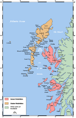
- To the West and North: The border starts in Ireland at a place called Bloody Foreland. It then goes to Tory Island and up to Barra Head. This is the southwest point of the Hebrides islands. The line then goes through these islands. The open ocean is on the west side of the main islands. All the narrow waters belong to the Inner Seas. This continues up to the Butt of Lewis, which is the North Point of the Hebrides. From there, the border goes to Cape Wrath in Scotland.
- To the South: The southern border connects two points. It goes from the Mull of Galloway in Scotland. It then crosses to Ballyquintin Point in Ireland.
What water bodies are part of the Inner Seas?
This area includes many different parts of the sea. Some of these are the Minch and Little Minch. You'll also find the Sound of Harris and the Inner Sound. Other important areas are the Sea of the Hebrides and the Firth of Lorn. The Sound of Jura and the Firth of Clyde are also included. Finally, Belfast Lough and the North Channel are part of these Inner Seas.
 | Kyle Baker |
 | Joseph Yoakum |
 | Laura Wheeler Waring |
 | Henry Ossawa Tanner |


