Ira, Vermont facts for kids
Quick facts for kids
Ira, Vermont
|
|
|---|---|

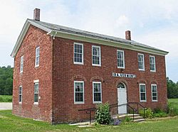
Ira town hall
|
|

Ira, Vermont
|
|
| Country | United States |
| State | Vermont |
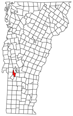
| County | Rutland |
| Area | |
| • Total | 21.3 sq mi (55.2 km2) |
| • Land | 21.3 sq mi (55.2 km2) |
| • Water | 0.0 sq mi (0.0 km2) |
| Elevation | 1,076 ft (328 m) |
| Population
(2020)
|
|
| • Total | 368 |
| • Density | 17.28/sq mi (6.667/km2) |
| Time zone | UTC-5 (Eastern (EST)) |
| • Summer (DST) | UTC-4 (EDT) |
| ZIP Codes | |
| Area code(s) | 802 |
| FIPS code | 50-35425 |
| GNIS feature ID | 1462123 |
Ira is a small town located in Rutland County, Vermont, in the United States. In 2020, about 368 people lived there.
The town was named after Ira Allen. He was the brother of Ethan Allen. Both were important figures in the Revolutionary War. They were part of a group called the Green Mountain Boys.
Where is Ira Located?
Ira is found in the state of Vermont. It covers an area of about 21.3 square miles (55.2 square kilometers). All of this area is land, meaning there are no large lakes or rivers within the town's borders.
A Look at Ira's Past
After the American Revolutionary War, a veteran named Lemuel Roberts lived in Ira. He was also a historian. Roberts served as a Captain in the local militia in Ira. A militia is a group of citizens who can be called upon to serve as soldiers, usually in emergencies.
How Many People Live in Ira?
The number of people living in Ira has changed over many years. Here is a quick look at the population counts from different census years:
| Historical population | |||
|---|---|---|---|
| Census | Pop. | %± | |
| 1790 | 312 | — | |
| 1800 | 473 | 51.6% | |
| 1810 | 519 | 9.7% | |
| 1820 | 498 | −4.0% | |
| 1830 | 442 | −11.2% | |
| 1840 | 430 | −2.7% | |
| 1850 | 400 | −7.0% | |
| 1860 | 422 | 5.5% | |
| 1870 | 413 | −2.1% | |
| 1880 | 479 | 16.0% | |
| 1890 | 421 | −12.1% | |
| 1900 | 350 | −16.9% | |
| 1910 | 286 | −18.3% | |
| 1920 | 295 | 3.1% | |
| 1930 | 287 | −2.7% | |
| 1940 | 248 | −13.6% | |
| 1950 | 232 | −6.5% | |
| 1960 | 220 | −5.2% | |
| 1970 | 284 | 29.1% | |
| 1980 | 354 | 24.6% | |
| 1990 | 426 | 20.3% | |
| 2000 | 455 | 6.8% | |
| 2010 | 432 | −5.1% | |
| 2020 | 368 | −14.8% | |
| U.S. Decennial Census | |||
In 2000, there were 455 people living in Ira. These people lived in 163 different homes. Most of these homes (125) were families.
The town had about 21 people per square mile. Most of the people living in Ira were White.
About 40% of the homes had children under 18 living there. Most families were married couples living together. The average household had about 2.79 people.
The people in Ira were of different ages. About 29.5% were under 18 years old. About 8.4% were 65 years or older. The average age in the town was 38 years old.
See also
 In Spanish: Ira (Vermont) para niños

